| During the month of April, Mark Miller will donate $75 to the charity of your choice (5 to chose from, including the Utah Avalanche Center!) Mark Miller Subaru has raised over $300k in the previous 6 Do Good Feel Good events. More Info here |  |
| During the month of April, Mark Miller will donate $75 to the charity of your choice (5 to chose from, including the Utah Avalanche Center!) Mark Miller Subaru has raised over $300k in the previous 6 Do Good Feel Good events. More Info here | |
| Advisory: Salt Lake Area Mountains | Issued by Drew Hardesty for Tuesday - March 11, 2014 - 5:53am |
|---|

|
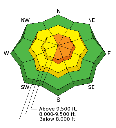
bottom line The morning starts out with a CONSIDERABLE danger for steep wind drifted terrain, most pronounced in the mid and upper elevation northeast to southeast facing slopes. Human triggered avalanches are probable in many areas, with wind drifts likely up to 18-24" deep or more in heavily loaded terrain. By the afternoon, the danger will trend toward MODERATE. The best and safest terrain today are one and the same - lower angle, mid-elevation (8-9500') northerly facing wind sheltered slopes...and it may be worth getting a bit later of a start today.
|
 |
special announcement
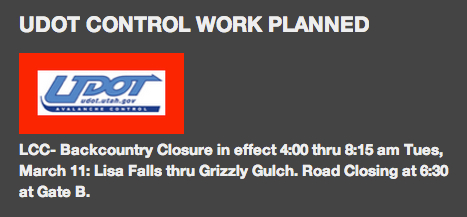
Tomorrow - UDOT Big Cottonwood will have a road closure at 730am - Backcountry closures will be in effect tomorrow for Broads and Stairs Gulch until they are finished.
|
 |
current conditions Classic textbook cold front material.
By the time you're reading this, the bulk of this nice little spring storm will have rolled through, though not without leaving behind a cool 5-8" of graupel/rimed snow... Pre-frontal (yesterday) - warm, overcast and moderate to strong pre-frontal southwesterly winds (30-40mph, gusting 50)... Frontal passage (6-9pm depending on location) - an intense frontal passage (powerful gusts to 70-80mph, a sharp wind shift to the west and northwest, temps dropping significantly, and a quick burst of snowfall - blink - and there's 2-3" of graupel on the ground)... Post-frontal (you're looking at it) - slowly diminishing winds...continued cooling trend...and snow showers with lighter density snow. Currently, temps are in the teens and ridgetop winds are 15-20mph with gusts to 30. It's still snowing. |
| type | aspect/elevation | characteristics |
|---|

|
|
LIKELIHOOD
 LIKELY
UNLIKELY
SIZE
 LARGE
SMALL
TREND
 INCREASING DANGER
SAME
DECREASING DANGER
|
|
description
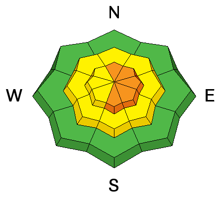
Generally speaking, the new snow should bond fairly well to the old, warm, rough and corrugated snow surfaces on all but the mid and upper elevation northerly slopes (where the new snow should bond slightly less well). But when it snows 1-2-3"/hour and/or the winds play a significant role, all bets are off. Wind drifts probably won't follow a well prescribed pattern - no doubt today you'll move between scoured and heavily drifted areas with wind slabs 3" deep over here, and wind slabs 18" deep over there. Most will be in terrain with an easterly component (northeast, east and southeast), but strong wind and powerful gusts generally lead to odd and unusual loading patterns...many drifts will be half-way down the slope. Cross-loaded gullies will be prime deposition zones today. TRAVEL ADVICE In any event, these drifts should respond well to cornice drops and slope cuts...and should become less sensitive and problematic as the day wears on. As lower elevation areas and mid-canyon snow amounts are reporting 5" thus far, probably the best and safest terrain are one and the same - lower angle, mid-elevation (8-9500') northerly facing wind sheltered slopes. Anything steeper and you start to "bottom feed" the old snow surfaces, drag your tails on the crusts, and push into more avalanche prone terrain. Quick note on cornice drops and slope cuts - with the wide variability on the drifting, you'll need to judge each bit of terrain on its individual merits.
|
| type | aspect/elevation | characteristics |
|---|

|
|
LIKELIHOOD
LIKELY
UNLIKELY
SIZE
 LARGE
SMALL
TREND
 INCREASING DANGER
SAME
DECREASING DANGER
|
|
description
Sluffing is likely in the most recent lower density snow and may be enough to pack a punch if in sustained steep terrain. |
| type | aspect/elevation | characteristics |
|---|

|
|
LIKELIHOOD
 LIKELY
UNLIKELY
SIZE
LARGE
SMALL
TREND
INCREASING DANGER
SAME
DECREASING DANGER
|
|
description
Storm snow avalanches involving graupel as a weak layer tend to be more commonly triggered at the base of cliffbands, in slope-steepness transitions (45 degree slopes that transition to 38 degrees per se), and in encatchment areas where the bouncing styrofoam balls tend to aggregate. (Again - note how the slope cut may miss the mark up high but be more critical well down the slope.) |
 |
weather We'll see overcast to mostly cloudy skies today with occasional spring-like instability showers over localized terrain. The winds lose steam and gradually veer more northerly today. Temps will be in the mid teens at 10,000' and the mid-20s at 8000'. We'll have partial clearing tonight with partly cloudy skies tomorrow. Winds will continue veering to the east for tomorrow. The next disturbance on Saturday looks a bit meager at this time. |
| general announcements
Remember your information can save lives. If you see anything we should know about, please participate in the creation of our own community avalanche advisory by submitting snow and avalanche conditions. You can also call us at 801-524-5304 or 800-662-4140, email by clicking HERE, or include #utavy in your tweet or Instagram. If you trigger an avalanche in the backcountry - especially if you are adjacent to a ski area – please call the following teams to alert them to the slide and whether anyone is missing or not. Rescue teams can be exposed to significant hazard when responding to avalanches, and do not want to do so when unneeded. Thanks. Salt Lake and Park City – Alta Central (801-742-2033), Canyons Resort Dispatch (435-615-3322) Snowbasin Resort Dispatch (801-620-1017), Powder Mountain Dispatch (801-745-3772 x 123). Sundance Dispatch (801-223-4150) EMAIL ADVISORY We have switched to a new SLC email advisory system. If you would like to get the daily advisory by email, or if you have been getting the advisory by email since the beginning of the season and wish to continue, you will need to subscribe here. DAWN PATROL Hotline updated daily by 5-530am - 888-999-4019 option 8. Twitter Updates for your mobile phone - DETAILS UDOT canyon closures: LINK TO UDOT Utah Avalanche Center mobile app - Get your advisory on your iPhone along with great navigation and rescue tools.uned. Wasatch Powderbird Guides Blog/Itinerary for the Day. Lost or Found something in the backcountry? - http://nolofo.com/ Discount lift tickets are now available at Backcountry.com - Thanks to Ski Utah and the Utah Resorts. All proceeds go towards paying for Utah Avalanche Center avalanche and mountain weather advisories. To those skinning uphill at resorts: it is your responsibility to know the resort policy on uphill travel. Some allow uphill travel and have guidelines, some don't. Contact the Ski Patrol at each resort for details. IMPORTANT: Before skinning at a resort under new snow conditions, check in with Ski Patrol. Resorts can restrict or cut off access if incompatible with control and grooming operations. Benefit the Utah Avalanche Center when you shop from Backcountry.com or REI: Click this link for Backcountry.com or this link to REI, shop, and they will donate a percent of your purchase price to the UAC. Both offer free shipping (with some conditions) so this costs you nothing! Benefit the Utah Avalanche Center when you buy or sell on ebay - set the Utah Avalanche Center as a favorite non-profit in your ebay account here and click on ebay gives when you buy or sell. You can choose to have your seller fees donated to the UAC, which doesn't cost you a penny. This information does not apply to developed ski areas or highways where avalanche control is normally done. This advisory is from the U.S.D.A. Forest Service, which is solely responsible for its content. This advisory describes general avalanche conditions and local variations always exist |