
| During the month of April, Mark Miller will donate $75 to the charity of your choice (5 to chose from, including the Utah Avalanche Center!) Mark Miller Subaru has raised over $300k in the previous 6 Do Good Feel Good events. More Info here |  |
| During the month of April, Mark Miller will donate $75 to the charity of your choice (5 to chose from, including the Utah Avalanche Center!) Mark Miller Subaru has raised over $300k in the previous 6 Do Good Feel Good events. More Info here | |
| Advisory: Salt Lake Area Mountains | Issued by Drew Hardesty for Wednesday - March 5, 2014 - 7:24am |
|---|

|
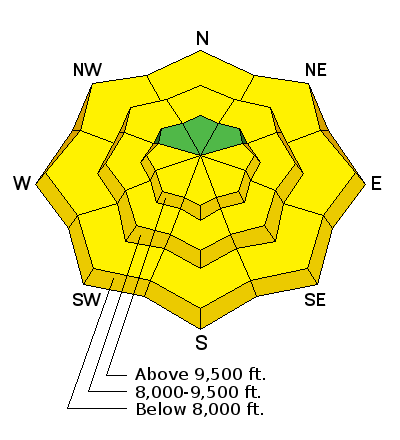
bottom line The danger will start off mostly LOW this morning, but will soon rise to MODERATE and then toward CONSIDERABLE on the steepest sunlit slopes with daytime warming. Natural and human triggered wet loose sluffs are a certainty. It's worth reading the fine print under the Wet Avalanche header. Isolated pockets of wind slab, lingering storm slab, and deeper releases are unlikely yet possible in the alpine. Safe and excellent riding can be found in the northerly aspects on 35 degrees and less today.
|
 |
special announcement Tomorrow 6pm at the Wildflower Lounge at Snowbird- GEOFFREY TABIN Impossible Dreams – The East Face of Everest and Eradicating World Blindness Geoffrey Tabin, M.D. is a Professor of Ophthalmology and Visual Sciences and director of International Ophthalmology at the John A. Moran Eye Center -University of Utah; and Founding Chairman of the Himalayan Cataract Project. Utah Adventure Journal Speaker Series is free of charge. Only guests 21+ are permitted into the Wildflower Lounge. First annual VertFest and 11th annual PowderKeg. Join us March 8th and 9th at Brighton Resort. There will be gear demos, a series of backcountry skills clinics, free beacon clinics, a party featuring the band Salem from Boulder, CO and a great gear raffle. The VertFest is a benefit for the Utah Avalanche Center. Click Here for more info. Show That You Know the Snow: US & Canadian avy groups have a challenge to sidecountry riders: Use your camera to tell a short video story about how your crew gets ready to safely ride beyond the resort boundary. Videos will be posted & promoted by GoPro & other partners. The contest will run till Mar 21. The winner will be determined by a combination of most views & an expert panel. Prizes include: 2 days at Monashee Powder Snowcats, 2 4-day Gold Passes to any US resort, a Backcountry Access Float 22 airbag, gear fromBackcountry.com, editing help and support from Sherpas Cinema, & more. Winners will be announced in late March. Details at knowthesnow.com Please share this with your friends. |
 |
current conditions Skies are clear, temps are in the mid-20s, and winds are generally less than 15mph from the west and northwest. Hard to complain about the 2-4" of new yesterday. The fresh veneer of paint came in at about 8-10% - maybe we'll call it the primer for Thursday night's storm - where we should add another 4-7". Skiing and riding conditions are excellent in the fast, dense powder. |
 |
recent activity In the central Wasatch, a skier traversing the top of one of the Wilson Chutes (link to wbskiing.com) was surprised by a lingering storm snow pocket that pulled out 10" deep and 15' wide. The Wilson Chutes are three steep chutes on the northeast side of Wilson Peak at 9900'...and I have to say I'm a bit surprised as well...as on average this pushes the traditional limits of activity associated with non-persistent weak layers. In any event, there was no incident to speak of and the party continued into Mill Creek to finish out the day. Beyond that, many found that generally harmless wet and dry sluffs in the new snow would run with provocation on the steeper slopes and rollovers. What do do when it all goes wrong? Check out guest blogger Tom Diegel's refresher on avalanche rescue management - |
| type | aspect/elevation | characteristics |
|---|

|
|
LIKELIHOOD
 LIKELY
UNLIKELY
SIZE
 LARGE
SMALL
TREND
 INCREASING DANGER
SAME
DECREASING DANGER
|
|
description
Like clockwork, wet loose avalanche activity will rise on the east, then south, then west facing slopes with direct sun and daytime warming. Natural and human triggered wet sluffs are a certainty today on the steep sunlit slopes as well as the low elevation northerlies. Moisture streaming in ahead of tomorrow's storm may offer some high thin cloud and resulting in green-housing, allowing the mid-elevation northerlies to get into the damp/wet loose action. Signs of Instability -
Make no mistake - no one wants to get dragged a thousand feet in snow with the consistency of what's dumped out of the south end of a cement mixer, but wet sluffs are generally considered "Manageable" by experienced skiers and riders - Here are the Hot Tips -
THE KEY POINT HERE IS THAT IF YOU CAN'T MANAGE THE SNOW, YOU HAVE TO MANAGE THE TERRAIN. [Loose wet avalanches: Usually manageable avalanche conditions associated with higher levels of certainty for experienced snow travelers. Normal Caution is advised. Test slopes, ski cuts, previous tracks, and cornice drops may provide some level of information on stability. More prevalent on the sunlight aspects (or as depicted in the current avalanche forecast). Avoid this terrain or choose slopes gentler than 40 degrees in steepness. Give runout zones a wide berth when natural avalanches are expected or when others may be traveling above you.]
|
| type | aspect/elevation | characteristics |
|---|

|
|
LIKELIHOOD
 LIKELY
UNLIKELY
SIZE
LARGE
SMALL
TREND
INCREASING DANGER
SAME
DECREASING DANGER
|
|
description
Warming should accentuate the sensitivity of the yawning whales. Give these monsters a wide berth and never approach a ridgeline if you can't tell if it's corniced or not. In the crowded Wasatch, never drop a cornice if you can't see the runout below. |
 |
weather Boy the bluebird'll sing today. Temps will rise to the mid-40s at 8000' and the mid-30s at 10,000 easy. Winds'll be less than 15mph initially then pick up from the southwest this afternoon. The next storm arrives tomorrow through early Friday with 4-7" of snow likely. Lightning and convective showers will potentially accompany this next storm. The weekend should dawn clear with the next set of disturbances set for next week. |
| general announcements
Remember your information can save lives. If you see anything we should know about, please participate in the creation of our own community avalanche advisory by submitting snow and avalanche conditions. You can also call us at 801-524-5304 or 800-662-4140, email by clicking HERE, or include #utavy in your tweet or Instagram. If you trigger an avalanche in the backcountry - especially if you are adjacent to a ski area – please call the following teams to alert them to the slide and whether anyone is missing or not. Rescue teams can be exposed to significant hazard when responding to avalanches, and do not want to do so when unneeded. Thanks. Salt Lake and Park City – Alta Central (801-742-2033), Canyons Resort Dispatch (435-615-3322) Snowbasin Resort Dispatch (801-620-1017), Powder Mountain Dispatch (801-745-3772 x 123). Sundance Dispatch (801-223-4150) EMAIL ADVISORY We have switched to a new SLC email advisory system. If you would like to get the daily advisory by email, or if you have been getting the advisory by email since the beginning of the season and wish to continue, you will need to subscribe here. DAWN PATROL Hotline updated daily by 5-530am - 888-999-4019 option 8. Twitter Updates for your mobile phone - DETAILS UDOT canyon closures: LINK TO UDOT Utah Avalanche Center mobile app - Get your advisory on your iPhone along with great navigation and rescue tools.uned. Wasatch Powderbird Guides Blog/Itinerary for the Day. Lost or Found something in the backcountry? - http://nolofo.com/ Discount lift tickets are now available at Backcountry.com - Thanks to Ski Utah and the Utah Resorts. All proceeds go towards paying for Utah Avalanche Center avalanche and mountain weather advisories. To those skinning uphill at resorts: it is your responsibility to know the resort policy on uphill travel. Some allow uphill travel and have guidelines, some don't. Contact the Ski Patrol at each resort for details. IMPORTANT: Before skinning at a resort under new snow conditions, check in with Ski Patrol. Resorts can restrict or cut off access if incompatible with control and grooming operations. Benefit the Utah Avalanche Center when you shop from Backcountry.com or REI: Click this link for Backcountry.com or this link to REI, shop, and they will donate a percent of your purchase price to the UAC. Both offer free shipping (with some conditions) so this costs you nothing! Benefit the Utah Avalanche Center when you buy or sell on ebay - set the Utah Avalanche Center as a favorite non-profit in your ebay account here and click on ebay gives when you buy or sell. You can choose to have your seller fees donated to the UAC, which doesn't cost you a penny. This information does not apply to developed ski areas or highways where avalanche control is normally done. This advisory is from the U.S.D.A. Forest Service, which is solely responsible for its content. This advisory describes general avalanche conditions and local variations always exist. |


