| During the month of April, Mark Miller will donate $75 to the charity of your choice (5 to chose from, including the Utah Avalanche Center!) Mark Miller Subaru has raised over $300k in the previous 6 Do Good Feel Good events. More Info here |  |
| During the month of April, Mark Miller will donate $75 to the charity of your choice (5 to chose from, including the Utah Avalanche Center!) Mark Miller Subaru has raised over $300k in the previous 6 Do Good Feel Good events. More Info here | |
| Advisory: Salt Lake Area Mountains | Issued by Evelyn Lees for Sunday - March 2, 2014 - 6:51am |
|---|

|
bottom line The AVALANCHE DANGER is CONSIDERABLE on any steep mid and upper elevation slope with recent drifts of wind-blown snow. Out of the wind drifted terrain, there is an overall MODERATE avalanche danger on steep slopes for wet sluffs with any sun or daytime heating, new snow slides and the isolated chance of triggering a deeper slide.
|
 |
special announcement Join us March 8th and 9th at Brighton Resort for the first annual VertFest and 11th annual PowderKeg. There will be gear demos, a series of backcountry skills clinics, free beacon clinics, a party featuring the band Salem from Boulder, CO and a great gear raffle. The VertFest is a benefit for the Utah Avalanche Center. Click Here to find out more and to sign up for the backcountry clinics. Show Us You Know the Snow: US & Canadian avy groups have a challenge to sidecountry riders: Use your camera to tell a short video story about how your crew gets ready to safely ride beyond the resort boundary. Videos will be posted & promoted by GoPro & other partners. The contest will run till Mar 21. The winner will be determined by a combination of most views & an expert panel. Prizes include: 2 days at Monashee Powder Snowcats, 2 4-day Gold Passes to any US resort, a Backcountry Access Float 22 airbag, gear from Backcountry.com, editing help and support from Sherpas Cinema, & more. Winners will be announced in late March. . Details at knowthesnow.com Please share this with your friends |
 |
current conditions Under mostly cloudy skies, a few flakes are still falling in the mountains. Temperatures are mostly in the 20’s, and the westerly winds are so light –even the highest ridgeline stations are averaging less than 20 mph. The Ogden mountains were the clear winners for snow in the past 24 hours: 7 – 11”. The Park City, Provo and Cottonwoods have received about 2 to 6” of new snow in the past 24 hours. Approximate storm totals since Thursday are:
|
 |
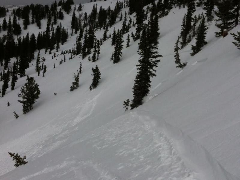
recent activity There were several new snow slides triggered in the backcountry yesterday - 2 in the east bowl of Silver Fork, 1 Grizzly Gulch, and possibly 3 outside of Brighton’s area boundary. The resorts had widespread new snow activity, from both ski cuts and explosives. Some deeper slides, to 3 feet, were triggered below cliff bands, where the graupel has pooled. Left photo - Grizzly Gulch, LCC Right photo - East Bowl of Silver Fork, BCC
|
| type | aspect/elevation | characteristics |
|---|

|
|
LIKELIHOOD
 LIKELY
UNLIKELY
SIZE
 LARGE
SMALL
TREND
 INCREASING DANGER
SAME
DECREASING DANGER
|
|
description
Wind Slabs People will still be able to trigger 1 to 2 foot deep wind drifts, though they will be much more stubborn today. Strong winds loaded the snow into deeper, more erratic pockets, both along ridge lines and down into the mid elevations and into open bowl. These isolated drifts will vary greatly over very short distances, with deep pockets in one spot, and the slope scoured clean in another. Dense and cracky snow is a clue you are in a drifted area. Storm Snow Out of the wind drifted terrain, most of the new snow instabilities should have settled out, but use caution on steep slopes. Also identify and avoid places where the graupel has rolled down cliffs or steep slopes and pooled. Deeper slides could be triggered in these spots. |
| type | aspect/elevation | characteristics |
|---|

|

|
LIKELIHOOD
 LIKELY
UNLIKELY
SIZE
LARGE
SMALL
TREND
 INCREASING DANGER
SAME
DECREASING DANGER
|
|
description
Breaks in the clouds are possible today, and even brief periods of sun will allow the snow to rapidly heat, especially on steep sunny slopes and on all low to mid elevation slopes. Wet snow sluffs will become very easy to trigger. Have an exit plan that avoids steep, sunny slopes and low elevation terrain traps should the snow heat up. |
| type | aspect/elevation | characteristics |
|---|

|
|
LIKELIHOOD
 LIKELY
UNLIKELY
SIZE
 LARGE
SMALL
TREND
INCREASING DANGER
SAME
DECREASING DANGER
|
|
description
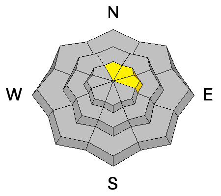
I am still suspicious that in a few isolated places a slide could be triggered on one of the more deeply buried faceted layers, probably by a large trigger such as explosives, multiple snow machines or the weight of a new snow slide. Traditionally shallower snow pack areas – like Mt Aire, Mineral Fork, parts of Mill Creek – are possibilities, as are shallow rocky areas and hanging snow fields. |
 |
weather A moist westerly flow will persist over northern Utah through Tuesday, with very weak disturbances rippling through. One is ending this morning, and today skies will be overcast to partly sunny, with 10,000’ temperatures warming into the mid-20s, and 8000’ temperatures warming to near 30. The westerly winds will remain light today, with even the highest peaks averaging 25 mph or less. Winds will increase slightly tonight as another very weak disturbance moves through, with the possibility of a few snow showers tonight, especially north of I-80. |
| general announcements Remember your information can save lives. If you see anything we should know about, please participate in the creation of our own community avalanche advisory by submitting snow and avalanche conditions. You can also call us at 801-524-5304 or 800-662-4140, email by clicking HERE, or include #utavy in your tweet or Instagram. If you trigger an avalanche in the backcountry - especially if you are adjacent to a ski area – please call the following teams to alert them to the slide and whether anyone is missing or not. Rescue teams can be exposed to significant hazard when responding to avalanches, and do not want to do so when unneeded. Thanks. Salt Lake and Park City – Alta Central (801-742-2033), Canyons Resort Dispatch (435-615-3322) Snowbasin Resort Dispatch (801-620-1017), Powder Mountain Dispatch (801-745-3772 x 123). Sundance Dispatch (801-223-4150) EMAIL ADVISORY We have switched to a new SLC email advisory system. If you would like to get the daily advisory by email, or if you have been getting the advisory by email since the beginning of the season and wish to continue, you will need to subscribe here. DAWN PATROL Hotline updated daily by 5-530am - 888-999-4019 option 8. Twitter Updates for your mobile phone - DETAILS UDOT canyon closures: LINK TO UDOT Utah Avalanche Center mobile app - Get your advisory on your iPhone along with great navigation and rescue tools.uned. Wasatch Powderbird Guides Blog/Itinerary for the Day. Lost or Found something in the backcountry? - http://nolofo.com/ Discount lift tickets are now available at Backcountry.com - Thanks to Ski Utah and the Utah Resorts. All proceeds go towards paying for Utah Avalanche Center avalanche and mountain weather advisories. To those skinning uphill at resorts: it is your responsibility to know the resort policy on uphill travel. Some allow uphill travel and have guidelines, some don't. Contact the Ski Patrol at each resort for details. IMPORTANT: Before skinning at a resort under new snow conditions, check in with Ski Patrol. Resorts can restrict or cut off access if incompatible with control and grooming operations. Benefit the Utah Avalanche Center when you shop from Backcountry.com or REI: Click this link for Backcountry.com or this link to REI, shop, and they will donate a percent of your purchase price to the UAC. Both offer free shipping (with some conditions) so this costs you nothing! Benefit the Utah Avalanche Center when you buy or sell on ebay - set the Utah Avalanche Center as a favorite non-profit in your ebay account here and click on ebay gives when you buy or sell. You can choose to have your seller fees donated to the UAC, which doesn't cost you a penny. This information does not apply to developed ski areas or highways where avalanche control is normally done. This advisory is from the U.S.D.A. Forest Service, which is solely responsible for its content. This advisory describes general avalanche conditions and local variations always exist. |