| During the month of April, Mark Miller will donate $75 to the charity of your choice (5 to chose from, including the Utah Avalanche Center!) Mark Miller Subaru has raised over $300k in the previous 6 Do Good Feel Good events. More Info here |  |
| During the month of April, Mark Miller will donate $75 to the charity of your choice (5 to chose from, including the Utah Avalanche Center!) Mark Miller Subaru has raised over $300k in the previous 6 Do Good Feel Good events. More Info here | |
| Advisory: Salt Lake Area Mountains | Issued by Evelyn Lees for Saturday - March 1, 2014 - 7:16am |
|---|

|
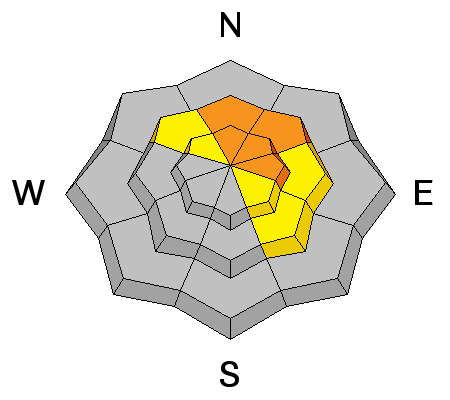
bottom line The AVALANCHE DANGER is HIGH on and below all steep, upper elevation slopes and high ridgelines, especially those with drifts of wind-blown snow. Both spontaneous and easily triggered avalanches are likely. Mid elevation slopes have a CONSIDERABLE danger. The low elevation slopes have a MODERATE DANGER for wet slides. Backcountry travel in avalanche terrain is not recommended. GO TO Terrain: For people with expert level route finding and snow evaluation skills, head to terrain less steep than about 30 degrees, not connected to steeper slopes, and avoid all runout zones, as avalanches are running long distances.
|
 |
avalanche warning THIS AVALANCHE WARNING IS FOR THE MOUNTAINS OF NORTHERN AND CENTRAL UTAH. HEAVY SNOW AND HIGH WINDS WILL CREATE A HIGH AVALANCHE DANGER. BACKCOUNTRY TRAVELERS SHOULD STAY ON SLOPES LESS THAN 30 DEGREES AND AVOID AVALANCHE RUN OUT AREAS.
|
 |
special announcement Join us March 8th and 9th at Brighton Resort for the first annual VertFest and 11th annual PowderKeg. There will be gear demos, a series of backcountry skills clinics, free beacon clinics, a party featuring the band Salem from Boulder, CO and a great gear raffle. The VertFest is a benefit for the Utah Avalanche Center. Click Here to find out more and to sign up for the backcountry clinics. Show Us You Know the Snow: US & Canadian avy groups have a challenge to sidecountry riders: Use your camera to tell a short video story about how your crew gets ready to safely ride beyond the resort boundary. Videos will be posted & promoted by GoPro & other partners. The contest will run till Mar 21. The winner will be determined by a combination of most views & an expert panel. Prizes include: 2 days at Monashee Powder Snowcats, 2 4-day Gold Passes to any US resort, a Backcountry Access Float 22 airbag, gear from Backcountry.com, editing help and support from Sherpas Cinema, & more. Winners will be announced in late March. . Details at knowthesnow.com Please share this with your friends |
 |
current conditions The southwesterly winds have been nuking along the high ridges since midnight, with averages to 45 mph in some locations, and gusts in the 50 to 70 mph range. Even mid elevation stations have had gusts into the 60s. Temperatures are still unseasonably warm – in the upper 20s to low 30s this morning, but finally cooling. An additional 4 to 10” of snow fell overnight, and rough storm totals are:
|
 |
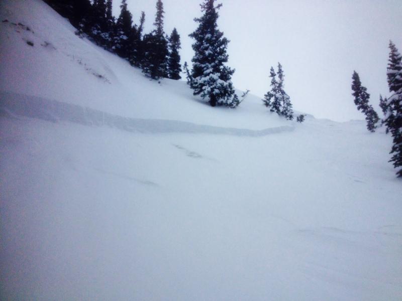
recent activity Yesterday was remarkable for how poorly behaved 12 inches or less of snow can be. With good hard bed surfaces, a period of sun and wind the obvious catalysts, there was widespread natural, explosive and human triggered new snow soft slab avalanches and wind slabs, averaging a foot deep and 100’ wide, especially in the heavily trafficked upper elevations of LCC and BCC. Avalanche list HERE. A long running slide coming off the east side of Kessler is a stand out, with debris almost reaching the summer road. INFO HERE Pink Pine, LCC, slide below.
|
| type | aspect/elevation | characteristics |
|---|

|
|
LIKELIHOOD
 LIKELY
UNLIKELY
SIZE
 LARGE
SMALL
TREND
 INCREASING DANGER
SAME
DECREASING DANGER
|
|
description
Today, expect more of the same, but with slides having the potential to be wider and deeper, and continuing to run further than expected. Distribution will be trickier, however - hours of strong winds at the upper and mid elevations have eroded and drifted the snow. Snow depths and drifts will vary greatly over very short distances, with deep pockets in one spot, and the slope scoured clean in another. If you start finding the drifts to be more stubborn, it just means when it does go, it will really “pop”, and be wider and deeper. Surprise pockets of drifted snow exist well off the ridgelines and at mid elevations. Bursts of heavy snowfall are possible today, and if you are in an area where it starts snowing 2” an hour, the newest snow will rapidly become unstable. |
| type | aspect/elevation | characteristics |
|---|

|
|
LIKELIHOOD
 LIKELY
UNLIKELY
SIZE
 LARGE
SMALL
TREND
 INCREASING DANGER
SAME
DECREASING DANGER
|
|
description
Wet snow sluffs can be triggered today on the steep, lower elevation slopes. If the clouds thin at all where you are, expect the snow on steep sunny slopes of all elevations to heat up remarkably fast. |
| type | aspect/elevation | characteristics |
|---|

|
|
LIKELIHOOD
 LIKELY
UNLIKELY
SIZE
LARGE
SMALL
TREND
 INCREASING DANGER
SAME
DECREASING DANGER
|
|
description
Once again, there is the possibility of triggering a slide on the more deeply buried facets that exist both mid pack and near the ground. One of today’s new snow slides may have enough weight to step down and trigger a deeper slide, with shallower snowpack areas particularly suspect. This problem is most widespread on northerly through easterly facing slopes at the upper elevations. |
 |
weather Expect strong southwesterly winds to continue through noon today, as the cold front moves out of state. Speeds in the 40 to 50 mph range, with gusts in the 70s and 80s, will continue along the higher ridgelines. Even the mid elevations will have average speeds to 30, with gusts in the 50s. The winds will very slowly decrease throughout the day. 10,000’ temperatures will be in the low 20s, 8000’ temperatures in the upper 20s. Periods of heavy convective snowfall, mixed with lulls, are possible today. One drainage may end up with 6 or 7” of new snow, another with only 1”. Lingering snow showers tonight and Sunday, will add a few more inches of snow, and thankfully the westerly winds will continue to decrease. |
| general announcements Remember your information can save lives. If you see anything we should know about, please participate in the creation of our own community avalanche advisory by submitting snow and avalanche conditions. You can also call us at 801-524-5304 or 800-662-4140, email by clicking HERE, or include #utavy in your tweet or Instagram. If you trigger an avalanche in the backcountry - especially if you are adjacent to a ski area – please call the following teams to alert them to the slide and whether anyone is missing or not. Rescue teams can be exposed to significant hazard when responding to avalanches, and do not want to do so when unneeded. Thanks. Salt Lake and Park City – Alta Central (801-742-2033), Canyons Resort Dispatch (435-615-3322) Snowbasin Resort Dispatch (801-620-1017), Powder Mountain Dispatch (801-745-3772 x 123). Sundance Dispatch (801-223-4150) EMAIL ADVISORY We have switched to a new SLC email advisory system. If you would like to get the daily advisory by email, or if you have been getting the advisory by email since the beginning of the season and wish to continue, you will need to subscribe here. DAWN PATROL Hotline updated daily by 5-530am - 888-999-4019 option 8. Twitter Updates for your mobile phone - DETAILS UDOT canyon closures: LINK TO UDOT Utah Avalanche Center mobile app - Get your advisory on your iPhone along with great navigation and rescue tools.uned. Wasatch Powderbird Guides Blog/Itinerary for the Day. Lost or Found something in the backcountry? - http://nolofo.com/ Discount lift tickets are now available at Backcountry.com - Thanks to Ski Utah and the Utah Resorts. All proceeds go towards paying for Utah Avalanche Center avalanche and mountain weather advisories. To those skinning uphill at resorts: it is your responsibility to know the resort policy on uphill travel. Some allow uphill travel and have guidelines, some don't. Contact the Ski Patrol at each resort for details. IMPORTANT: Before skinning at a resort under new snow conditions, check in with Ski Patrol. Resorts can restrict or cut off access if incompatible with control and grooming operations. Benefit the Utah Avalanche Center when you shop from Backcountry.com or REI: Click this link for Backcountry.com or this link to REI, shop, and they will donate a percent of your purchase price to the UAC. Both offer free shipping (with some conditions) so this costs you nothing! Benefit the Utah Avalanche Center when you buy or sell on ebay - set the Utah Avalanche Center as a favorite non-profit in your ebay account here and click on ebay gives when you buy or sell. You can choose to have your seller fees donated to the UAC, which doesn't cost you a penny. This information does not apply to developed ski areas or highways where avalanche control is normally done. This advisory is from the U.S.D.A. Forest Service, which is solely responsible for its content. This advisory describes general avalanche conditions and local variations always exist. |