
| During the month of April, Mark Miller will donate $75 to the charity of your choice (5 to chose from, including the Utah Avalanche Center!) Mark Miller Subaru has raised over $300k in the previous 6 Do Good Feel Good events. More Info here |  |
| During the month of April, Mark Miller will donate $75 to the charity of your choice (5 to chose from, including the Utah Avalanche Center!) Mark Miller Subaru has raised over $300k in the previous 6 Do Good Feel Good events. More Info here | |
| Advisory: Salt Lake Area Mountains | Issued by Evelyn Lees for Monday - February 24, 2014 - 6:57am |
|---|

|
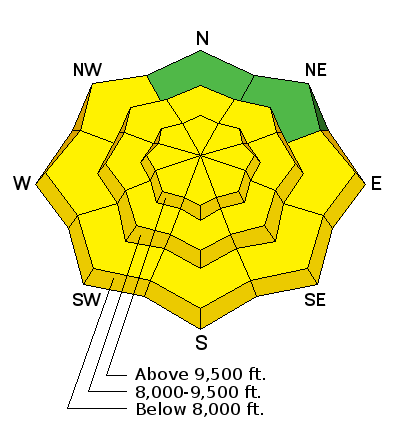
bottom line The overall AVALANCHE DANGER is MODERATE on all mid and upper elevation slopes.
|
 |
special announcement Do the positive response from our first ever Snowshoe Backcountry 101 classes, we are running one more, with the lecture Wednesday evening, February 26, and the field day at Brighton on March 1. Sign up here. |
 |
current conditions Meteorological spring is just around the corner (March 1), and spring is what it feels like this morning. Temperatures are currently in the mid 20’s to low 30s, and skies are clear to partly cloudy. The westerly winds are averaging less than 15 mph at most locations, with only a few of the very highest peaks having average speeds to 35 mph. Shady, wind sheltered slopes have excellent dry powder. |
 |
recent activity The only new avalanches reported yesterday were wet loose sluffs on some steep sunny mid elevation slopes. |
| type | aspect/elevation | characteristics |
|---|

|
|
LIKELIHOOD
 LIKELY
UNLIKELY
SIZE
 LARGE
SMALL
TREND
 INCREASING DANGER
SAME
DECREASING DANGER
|
|
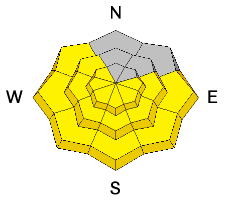
description
Wet sluffs will be the most widespread avalanches today. While temperatures have a definite head start over yesterday morning of 5 to 10 degrees, the cloud cover will be in control and is the wild card today. If you’re in drainage with clear skies and direct sun, the snow will rapidly warm on steep slopes - first east, then south, then westerly facing slopes. If you are in an area with just the right amount of high thin clouds – add mid elevation northerly facing slopes into the mix for wet loose sluffs, too. Watch for the heating progression – roller balls are the first sign that the snow is heating. Next, it will be easy to trigger wet sluffs with your boards or snow machines, and finally, spontaneous wet sluffs that can grow to be quite large and result in deep debris piles, especially in confined terrain such as gullies. |
| type | aspect/elevation | characteristics |
|---|

|
|
LIKELIHOOD
 LIKELY
UNLIKELY
SIZE
 LARGE
SMALL
TREND
 INCREASING DANGER
SAME
DECREASING DANGER
|
|
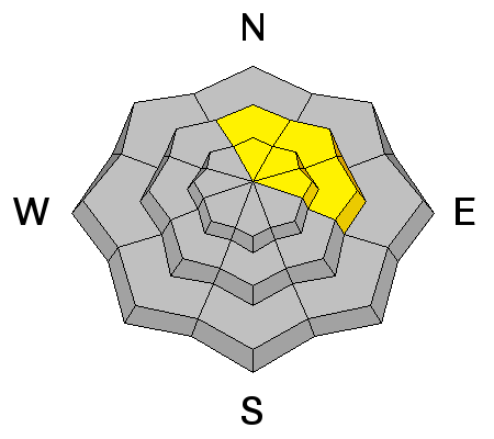
description
In very isolated areas, a deeper slide could still be triggered - think hanging snow fields, shallower snow pack areas outside of the upper Cottonwoods, or with large triggers, such as multiple people or snowmobiles on a slope or dropping a large cornice on a slope. The serious nature of these potential slides means conservative choices on upper elevation north through easterly facing slopes is advised. |
| type | aspect/elevation | characteristics |
|---|

|
|
LIKELIHOOD
LIKELY
UNLIKELY
SIZE
LARGE
SMALL
TREND
 INCREASING DANGER
SAME
DECREASING DANGER
|
|
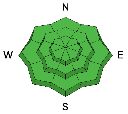
description
Low danger means using low risk travel techniques of one at a time, having an escape route planned and constantly evaluating the snow conditions. Today, be especially alert for:
|
 |
weather A mild, westerly flow will continue through mid-week, with intermittent clouds, especially north of I-80. Variable cloud cover today could result in anything from direct sun to mostly cloudy skies. 10,000’ temperatures will warm into the upper 20s today, and remain there through Wednesday. 8,000’ temperatures may hit 40 this afternoon. The westerly winds should decrease slightly this afternoon, and remain mostly light through tonight. Near the end of the week, a series of troughs will bring snow to the mountains. Current timing brings in the first storm on Thursday, a break on Friday, followed by another storm on Saturday. |
| general announcements Remember your information can save lives. If you see anything we should know about, please participate in the creation of our own community avalanche advisory by submitting snow and avalanche conditions. You can also call us at 801-524-5304 or 800-662-4140, email by clicking HERE, or include #utavy in your tweet or Instagram. If you trigger an avalanche in the backcountry - especially if you are adjacent to a ski area – please call the following teams to alert them to the slide and whether anyone is missing or not. Rescue teams can be exposed to significant hazard when responding to avalanches, and do not want to do so when unneeded. Thanks. Salt Lake and Park City – Alta Central (801-742-2033), Canyons Resort Dispatch (435-615-3322) Snowbasin Resort Dispatch (801-620-1017), Powder Mountain Dispatch (801-745-3772 x 123). Sundance Dispatch (801-223-4150) EMAIL ADVISORY We have switched to a new SLC email advisory system. If you would like to get the daily advisory by email, or if you have been getting the advisory by email since the beginning of the season and wish to continue, you will need to subscribe here. DAWN PATROL Hotline updated daily by 5-530am - 888-999-4019 option 8. Twitter Updates for your mobile phone - DETAILS UDOT canyon closures: LINK TO UDOT Utah Avalanche Center mobile app - Get your advisory on your iPhone along with great navigation and rescue tools.uned. Wasatch Powderbird Guides Blog/Itinerary for the Day. Lost or Found something in the backcountry? - http://nolofo.com/ Discount lift tickets are now available at Backcountry.com - Thanks to Ski Utah and the Utah Resorts. All proceeds go towards paying for Utah Avalanche Center avalanche and mountain weather advisories. To those skinning uphill at resorts: it is your responsibility to know the resort policy on uphill travel. Some allow uphill travel and have guidelines, some don't. Contact the Ski Patrol at each resort for details. IMPORTANT: Before skinning at a resort under new snow conditions, check in with Ski Patrol. Resorts can restrict or cut off access if incompatible with control and grooming operations. Benefit the Utah Avalanche Center when you shop from Backcountry.com or REI: Click this link for Backcountry.com or this link to REI, shop, and they will donate a percent of your purchase price to the UAC. Both offer free shipping (with some conditions) so this costs you nothing! Benefit the Utah Avalanche Center when you buy or sell on ebay - set the Utah Avalanche Center as a favorite non-profit in your ebay account here and click on ebay gives when you buy or sell. You can choose to have your seller fees donated to the UAC, which doesn't cost you a penny. This information does not apply to developed ski areas or highways where avalanche control is normally done. This advisory is from the U.S.D.A. Forest Service, which is solely responsible for its content. This advisory describes general avalanche conditions and local variations always exist. |


