| During the month of April, Mark Miller will donate $75 to the charity of your choice (5 to chose from, including the Utah Avalanche Center!) Mark Miller Subaru has raised over $300k in the previous 6 Do Good Feel Good events. More Info here |  |
| During the month of April, Mark Miller will donate $75 to the charity of your choice (5 to chose from, including the Utah Avalanche Center!) Mark Miller Subaru has raised over $300k in the previous 6 Do Good Feel Good events. More Info here | |
| Advisory: Salt Lake Area Mountains | Issued by Bruce Tremper for Friday - February 21, 2014 - 5:52am |
|---|

|
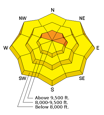
bottom line The avalanche danger is mostly MODERATE (yellow, Level 2) with areas of CONSIDERABLE (orange, Level 3) especially for the possibility of large, deep slabs on upper elevation northwest through east facing slopes. You may also find some sensitive wind slabs in upper elevation terrain and some shallow, wet sluffs on steep, sun exposed slopes today. You can always find safe terrain on slopes less than 30 degrees not locally connected to steeper terrain.
|
 |
special announcement Do the popularity and response from our first ever Snowshoe Backcountry 101 classes, we are running one more, with the lecture Wednesday evening, February 26, and the field day at Brighton on March 1. Sign up here. |
 |
current conditions It was quite cold yesterday with below zero on the high peaks but temperatures have warmed about 10 degrees this morning to the mid teens at 9,500'. Wind is from the west-northwest 20, gusting to 30 on the exposed ridge tops. The Salt Lake area mountains have about 8 inches of light powder from a couple days ago. Sorry, Ogden and Provo area mountains did not get any. It dramatically improved the turning and riding conditions and you can have plenty of fun on low angled terrain. The sun came out yesterday afternoon and crusted most of the sun exposed terrain. You can always check out the individual automated weather stations on the Snow Page. |
 |
recent activity We did not see or hear about any avalanche activity from yesterday except for a few small, soft wind slabs on steep terrain. |
| type | aspect/elevation | characteristics |
|---|

|

|
LIKELIHOOD
 LIKELY
UNLIKELY
SIZE
 LARGE
SMALL
TREND
 INCREASING DANGER
SAME
DECREASING DANGER
|
|
description
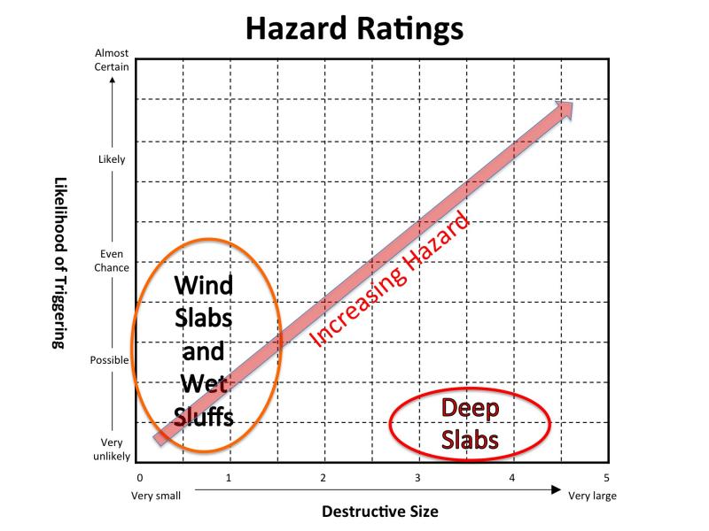
The monster deep slab avalanche dragons are mostly sleeping, or "dormant" as we call them. You can watch a video primer on the snowpack conditions in deep snowpack areas that I made yesterday along the Park City ridge line. These are classic low probability - high consequence avalanches. Especially when you combine high consequence snowpack (large avalanches) with high consequence terrain (terrain traps, trees, cliffs, etc) then you have a high risk situation even if the chances are low. At least for me, the risk is not worth it. Plus, the turning and riding conditions are so good on the gentle terrain you can leave the steep terrain or high consequence terrain for another day. For you folks, like me, who love graphs, here is a probability - consequence diagram of the different avalanche problems (types) that we have today. The most likely terrain you could still trigger one of these large, deep avalanches include shallow snowpack areas, steep, rocky slopes, and "repeater" slide paths (ones that slid in past weeks--thus shallower--and are now re loaded with snow). I'm thinking that the lower elevation terrain that got rain in the last storm and are now frozen, are safer than the upper elevation terrain. Needless to say, there is a lot of uncertainty associated with these avalanches so I usually just choose avoidance.
|
| type | aspect/elevation | characteristics |
|---|

|
|
LIKELIHOOD
 LIKELY
UNLIKELY
SIZE
 LARGE
SMALL
TREND
INCREASING DANGER
SAME
DECREASING DANGER
|
|
description
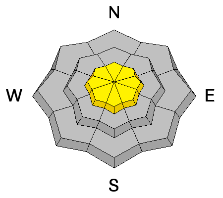
The wind blew hard from the west and northwest a couple days ago with the passage of the cold front, which created quite a bit of wind damage in the upper elevation, wind exposed terrain. Yesterday, the wind slabs were mostly soft and not very reactive but I'm sure you can find places today where one could catch and carry a person. You will find them mostly on northeast through southeast facing slopes. |
| type | aspect/elevation | characteristics |
|---|

|
|
LIKELIHOOD
 LIKELY
UNLIKELY
SIZE
LARGE
SMALL
TREND
 INCREASING DANGER
SAME
DECREASING DANGER
|
|
description
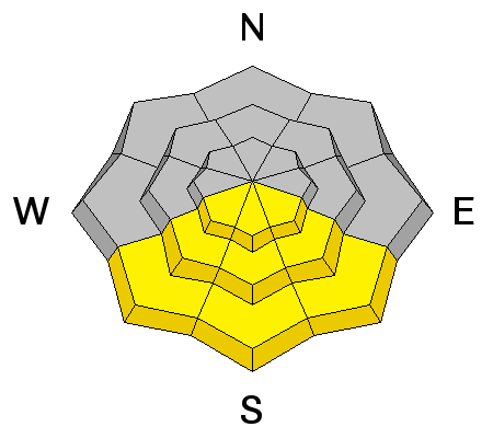
With periods of sun today combined with warmer temperatures, we will likely have some shallow, wet sluffs on the steep, sun exposed slopes at all elevations. Make sure one of these does not carry you into high consequence terrain. |
 |
weather We will have variable, scattered clouds today mostly at mountain-top elevations but we could get some high clouds later in the day. But we will see quite a bit of sun as well. Temperatures will be 10 degrees warmer than yesterday with daytime high in the mid 20's and the overnight low in the mid teens. Ridge top winds will continue to blow from the west and northwest 15, gusting to 20. This weekend, we will continue to have low and mid level clouds with the possibility of a few light snow showers. Temperatures will become quite warm after the weekend with a couple weak disturbances mid week to later next week. |
| general announcements Remember your information can save lives. If you see anything we should know about, please participate in the creation of our own community avalanche advisory by submitting snow and avalanche conditions. You can also call us at 801-524-5304 or 800-662-4140, email by clicking HERE, or include #utavy in your tweet or Instagram. If you trigger an avalanche in the backcountry - especially if you are adjacent to a ski area – please call the following teams to alert them to the slide and whether anyone is missing or not. Rescue teams can be exposed to significant hazard when responding to avalanches, and do not want to do so when unneeded. Thanks. Salt Lake and Park City – Alta Central (801-742-2033), Canyons Resort Dispatch (435-615-3322) Snowbasin Resort Dispatch (801-620-1017), Powder Mountain Dispatch (801-745-3772 x 123). Sundance Dispatch (801-223-4150) EMAIL ADVISORY We have switched to a new SLC email advisory system. If you would like to get the daily advisory by email, or if you have been getting the advisory by email since the beginning of the season and wish to continue, you will need to subscribe here. DAWN PATROL Hotline updated daily by 5-530am - 888-999-4019 option 8. Twitter Updates for your mobile phone - DETAILS UDOT canyon closures: LINK TO UDOT Utah Avalanche Center mobile app - Get your advisory on your iPhone along with great navigation and rescue tools.uned. Wasatch Powderbird Guides Blog/Itinerary for the Day. Lost or Found something in the backcountry? - http://nolofo.com/ Discount lift tickets are now available at Backcountry.com - Thanks to Ski Utah and the Utah Resorts. All proceeds go towards paying for Utah Avalanche Center avalanche and mountain weather advisories. To those skinning uphill at resorts: it is your responsibility to know the resort policy on uphill travel. Some allow uphill travel and have guidelines, some don't. Contact the Ski Patrol at each resort for details. IMPORTANT: Before skinning at a resort under new snow conditions, check in with Ski Patrol. Resorts can restrict or cut off access if incompatible with control and grooming operations. Benefit the Utah Avalanche Center when you shop from Backcountry.com or REI: Click this link for Backcountry.com or this link to REI, shop, and they will donate a percent of your purchase price to the UAC. Both offer free shipping (with some conditions) so this costs you nothing! Benefit the Utah Avalanche Center when you buy or sell on ebay - set the Utah Avalanche Center as a favorite non-profit in your ebay account here and click on ebay gives when you buy or sell. You can choose to have your seller fees donated to the UAC, which doesn't cost you a penny. This information does not apply to developed ski areas or highways where avalanche control is normally done. This advisory is from the U.S.D.A. Forest Service, which is solely responsible for its content. This advisory describes general avalanche conditions and local variations always exist. |