
| During the month of April, Mark Miller will donate $75 to the charity of your choice (5 to chose from, including the Utah Avalanche Center!) Mark Miller Subaru has raised over $300k in the previous 6 Do Good Feel Good events. More Info here |  |
| During the month of April, Mark Miller will donate $75 to the charity of your choice (5 to chose from, including the Utah Avalanche Center!) Mark Miller Subaru has raised over $300k in the previous 6 Do Good Feel Good events. More Info here | |
| Advisory: Salt Lake Area Mountains | Issued by Evelyn Lees for Thursday - February 20, 2014 - 6:49am |
|---|

|
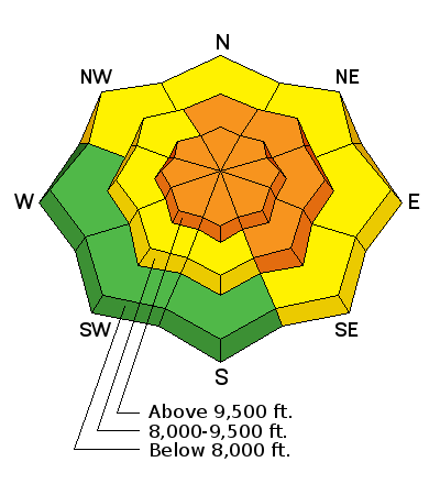
bottom line The AVALANCHE DANGER remains CONSIDERABLE on all steep mid and upper elevation slopes facing northwest through north through southeast for triggering a fresh wind drift or a deep slab avalanche breaking to the ground. Once again, the “GO TO” terrain is wind sheltered slopes less steep than about 34 degrees, that are not below or adjacent to a steeper slope.
|
 |
special announcement The final Women’s Backcountry 101 class for snowboarders and skiers starts tonight, with the field day this Saturday. This is a great opportunity to get out with the pros to build your avalanche skills and backcountry confidence. Sign up here. Do the popularity and response from our first ever Snowshoe Backcountry 101 classes, we are running one more, with the lecture Wednesday evening, February 26, and the field day at Brighton on March 1. Sign up here. Tonight: KEVIN FEDARKO, author of “The Emerald Mile: The Epic Story of the Fastest Ride in History Through the Heart of the Grand Canyon” will be speaking at Snowbird tonight, Thursday, Feb 20. His subject: Beneath the River of Shooting Stars: A Tale of Speed, Obsession, and Grace in the Grand Canyon. Utah Adventure Journal Speaker Series is free of charge. Only guests 21+ are permitted into the Wildflower Lounge. Enjoy nightly appetizer specials, $4 fireball whiskey shots and $5 fire cider drinks. There will be a raffle with great donated gear to benefit the Utah Avalanche Center. More info HERE. |
 |
current conditions It has a very cold, wintery feel out there this morning - most mid and upper elevation stations are in the low single digits and strong northwesterly winds continue to blow. The winds peaked overnight, but are still averaging around 35 mph, gusting in the 50s along the high ridgelines, with average speeds in the 20s at the mid elevations. Snow amounts slowly added up over the past 24 hours, – 5 to 9 inches in the Cottonwoods and on the Park City side, and a trace to 2 inches in the Provo and Ogden area mountains. Check out the 48 hour winds and temperature trends at the Alta Guard station below. |
 |
recent activity No new avalanches were reported yesterday, however most backcountry travelers avoided the wind swept ridgelines. The resorts reported easily triggered wind drifts. |
| type | aspect/elevation | characteristics |
|---|

|
|
LIKELIHOOD
 LIKELY
UNLIKELY
SIZE
 LARGE
SMALL
TREND
 INCREASING DANGER
SAME
DECREASING DANGER
|
|
description
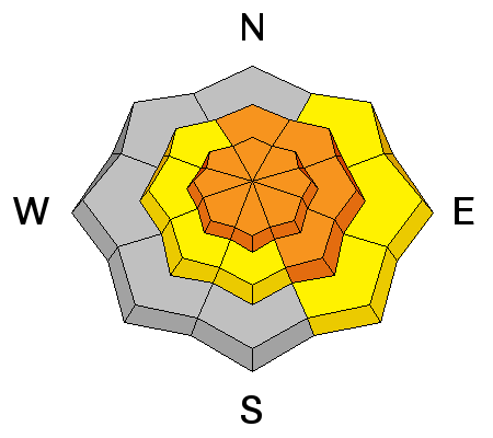
After last night’s strong northwesterly winds, landscape will be littered with both soft and denser drifts of wind-blown snow, on both the upper and mid elevation slopes. The drifts will be most widespread along northeasterly through southeasterly facing ridgelines. However, identify and avoid drifts where ever you find them, including on mid elevation slopes, around gully walls, the tops of slope break overs, and around sub ridges. Many slopes that slide during the past 2 weeks had weak snow remaining on the ground, and could slide again if heavily wind drifted. |
| type | aspect/elevation | characteristics |
|---|

|
|
LIKELIHOOD
 LIKELY
UNLIKELY
SIZE
 LARGE
SMALL
TREND
INCREASING DANGER
SAME
DECREASING DANGER
|
|
description
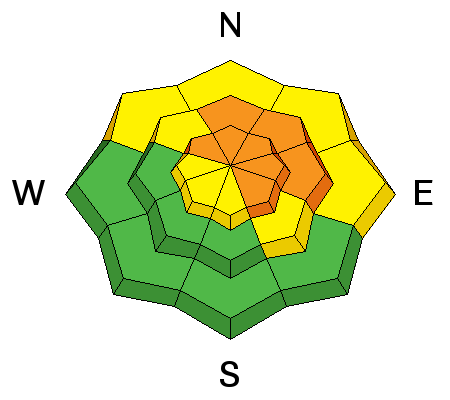
While new snow amounts were not impressive, the wind has deposited drifts over 2 feet deep on to slopes with weak underlying snow. This will once again increase the chance of triggering a deeper slab avalanche breaking mid pack or near the ground. Even slopes that slid over the past 2 weeks could slide again if heavily enough loaded by the wind. Slides could be triggered by a person, cornice drop or a wind slab. The only effective management for deep slabs is to avoid suspect slopes – not every slope will slide, but if it does it could be unsurvivable. |
| type | aspect/elevation | characteristics |
|---|

|
|
LIKELIHOOD
LIKELY
UNLIKELY
SIZE
LARGE
SMALL
TREND
INCREASING DANGER
SAME
DECREASING DANGER
|
|
description
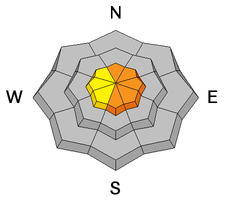
Cornices are continuing to build, and are sensitive. They almost always break back further than expected, so give them a wide berth. Be aware of where other backcountry parties are, and never drop a cornice without have clear visibility of the maximum run-out should the cornice trigger a larger slide. |
 |
weather A cool, moist northwesterly flow will be over northern Utah though Saturday night. Skies will be partly to mostly cloudy through the time period, with occasional chances for light snow, though any accumulations will be minor. Temperatures will warm slightly this afternoon, to near 10 degrees F at 10,000’ and into the 15 to 20 degree range at 8,000’. Unfortunately, the winds will remain blustery today – high ridgeline averages to 45 mph, with gusts in the 60s. The 10,000’ ridges will have speeds averaging to 25 mph, with gusts to 45. Sunday through Wednesday, partly cloudy but dry. |
| general announcements Remember your information can save lives. If you see anything we should know about, please participate in the creation of our own community avalanche advisory by submitting snow and avalanche conditions. You can also call us at 801-524-5304 or 800-662-4140, email by clicking HERE, or include #utavy in your tweet or Instagram. If you trigger an avalanche in the backcountry - especially if you are adjacent to a ski area – please call the following teams to alert them to the slide and whether anyone is missing or not. Rescue teams can be exposed to significant hazard when responding to avalanches, and do not want to do so when unneeded. Thanks. Salt Lake and Park City – Alta Central (801-742-2033), Canyons Resort Dispatch (435-615-3322) Snowbasin Resort Dispatch (801-620-1017), Powder Mountain Dispatch (801-745-3772 x 123). Sundance Dispatch (801-223-4150) EMAIL ADVISORY We have switched to a new SLC email advisory system. If you would like to get the daily advisory by email, or if you have been getting the advisory by email since the beginning of the season and wish to continue, you will need to subscribe here. DAWN PATROL Hotline updated daily by 5-530am - 888-999-4019 option 8. Twitter Updates for your mobile phone - DETAILS UDOT canyon closures: LINK TO UDOT Utah Avalanche Center mobile app - Get your advisory on your iPhone along with great navigation and rescue tools.uned. Wasatch Powderbird Guides Blog/Itinerary for the Day. Lost or Found something in the backcountry? - http://nolofo.com/ Discount lift tickets are now available at Backcountry.com - Thanks to Ski Utah and the Utah Resorts. All proceeds go towards paying for Utah Avalanche Center avalanche and mountain weather advisories. To those skinning uphill at resorts: it is your responsibility to know the resort policy on uphill travel. Some allow uphill travel and have guidelines, some don't. Contact the Ski Patrol at each resort for details. IMPORTANT: Before skinning at a resort under new snow conditions, check in with Ski Patrol. Resorts can restrict or cut off access if incompatible with control and grooming operations. Benefit the Utah Avalanche Center when you shop from Backcountry.com or REI: Click this link for Backcountry.com or this link to REI, shop, and they will donate a percent of your purchase price to the UAC. Both offer free shipping (with some conditions) so this costs you nothing! Benefit the Utah Avalanche Center when you buy or sell on ebay - set the Utah Avalanche Center as a favorite non-profit in your ebay account here and click on ebay gives when you buy or sell. You can choose to have your seller fees donated to the UAC, which doesn't cost you a penny. This information does not apply to developed ski areas or highways where avalanche control is normally done. This advisory is from the U.S.D.A. Forest Service, which is solely responsible for its content. This advisory describes general avalanche conditions and local variations always exist. |


