| During the month of April, Mark Miller will donate $75 to the charity of your choice (5 to chose from, including the Utah Avalanche Center!) Mark Miller Subaru has raised over $300k in the previous 6 Do Good Feel Good events. More Info here |  |
| During the month of April, Mark Miller will donate $75 to the charity of your choice (5 to chose from, including the Utah Avalanche Center!) Mark Miller Subaru has raised over $300k in the previous 6 Do Good Feel Good events. More Info here | |
| Advisory: Salt Lake Area Mountains | Issued by Evelyn Lees for Wednesday - February 19, 2014 - 7:00am |
|---|


|
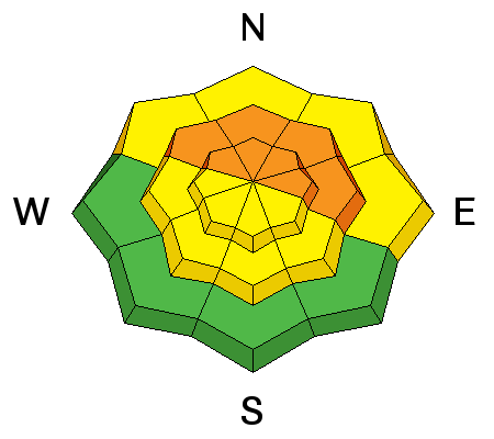
bottom line The AVALANCHE DANGER remains CONSIDERABLE on all mid and upper elevation slopes facing northwest through north through southeast for triggering a deep slab avalanche breaking to the ground. In addition, the avalanche danger will increase to CONSIDERABLE this afternoon and tonight on any steep slope with fresh drifts of wind-blown snow. Rapidly changing conditions often catch people unaware, and are when avalanche accidents occur.
|
 |
special announcement We'll be teaching a Backcountry 101 class on Thursday evening 2/20 and Saturday 2/22 for women only. This is a great opportunity to get out with the pros to build your avalanche skills and backcountry confidence. This will be our last Backcountry 101 avalanche class of the season for female skiers and splitboarders. Sign up here. The sun is getting higher and talk is changing to river trips. KEVIN FEDARKO, author of “The Emerald Mile: The Epic Story of the Fastest Ride in History Through the Heart of the Grand Canyon” will be speaking at Snowbird this Thursday, Feb 20. His subject: Beneath the River of Shooting Stars: A Tale of Speed, Obsession, and Grace in the Grand Canyon. Utah Adventure Journal Speaker Series is free of charge. Only guests 21+ are permitted into the Wildflower Lounge. Enjoy nightly appetizer specials, $4 fireball whiskey shots and $5 fire cider drinks. There will be a raffle with great donated gear to benefit the Utah Avalanche Center. More info HERE. |
 |
current conditions Clouds, winds and temperatures are all on the increase this morning, ahead of a cold front scheduled to arrive around noon. After a generally good overnight refreeze, temperatures have jumped up in the past few hours, into the mid-20s to mid-30s. The southwesterly winds are also kicking up their heels, currently averaging 20 to 30 mph along the high ridgelines, with gusts into the 50s. |
 |
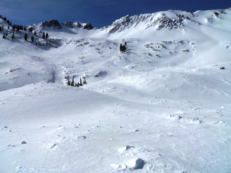
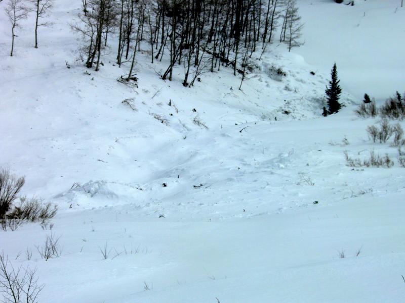
recent activity No new avalanches were reported yesterday. However, it was a good day for sightseeing, with many older slides from the weekend being reported. Check out all the new observations and photos HERE. In many cases, sharp attention to the debris helps fill in the picture even when you can't see the crowns. Mark White images from Cardiff Fork below
Bruce has an excellent new Blog on the past storm HERE. |
| type | aspect/elevation | characteristics |
|---|

|
|
LIKELIHOOD
 LIKELY
UNLIKELY
SIZE
 LARGE
SMALL
TREND
 INCREASING DANGER
SAME
DECREASING DANGER
|
|
description
While many slopes avalanched over the past weekend, I’m also impressed with the number of slopes that haven’t avalanche recently. On these slopes, there is still the potential for a person to trigger a deep slide. And while the chance of triggering one of these deep slides is becoming much less, the size and consequences remain the same – it’s not worth the chance. Recent slides have been most widespread on northwest through easterly facing slopes, above about 9,000’. And as these exact slopes get drifted later today with wind-blown snow, it will increase the chance of triggering a deep slab avalanche once again. |
| type | aspect/elevation | characteristics |
|---|

|
|
LIKELIHOOD
 LIKELY
UNLIKELY
SIZE
 LARGE
SMALL
TREND
INCREASING DANGER
SAME
DECREASING DANGER
|
|
description
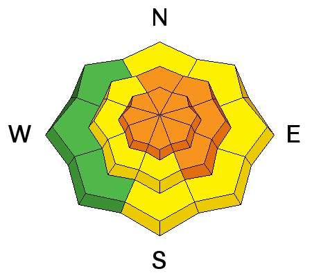
This morning, the brisk southwesterly winds are already drifting snow. But the danger of triggering a fresh wind drift will rapidly increase this afternoon into this evening. 5 to 10 inches of new snow, accompanied by strong post frontal northwesterly winds, will rapidly build new drifts. They will be especially widespread along the high ridgelines, on northeast through southeasterly facing slopes. However, drifts will also build on mid elevation slopes, and be cross loaded around gully walls, on slope break overs, and around sub ridges on a variety of aspects. Cornices will become sensitive. Avoid all steep wind drifted slopes, including slopes that avalanched during the past 2 weeks. |
 |
weather Light snow will develop this morning ahead of the cold front, which should cross the Salt Lake mountains around noon. There is a 20% chance of lightning with frontal passage. Several hours of heavy snow are possible behind the front, and the winds will shift to the northwest and increase. 20 to 30 mph averages are expected at most stations, with gusts into the 50s. Along the high ridges, averages to 45 mph, with gusts to 80 are possible. 10,000’ temperatures will plummet – from the mid-20s into the single digits by evening. Average storm totals of 5 to 10” are expected, with locally higher amounts possible for drainages favored by northwest flow. A break on Thursday will be followed by a final, smaller storm, bringing a shot of snow around Friday night or Saturday morning. |
| general announcements Remember your information can save lives. If you see anything we should know about, please participate in the creation of our own community avalanche advisory by submitting snow and avalanche conditions. You can also call us at 801-524-5304 or 800-662-4140, email by clicking HERE, or include #utavy in your tweet or Instagram. If you trigger an avalanche in the backcountry - especially if you are adjacent to a ski area – please call the following teams to alert them to the slide and whether anyone is missing or not. Rescue teams can be exposed to significant hazard when responding to avalanches, and do not want to do so when unneeded. Thanks. Salt Lake and Park City – Alta Central (801-742-2033), Canyons Resort Dispatch (435-615-3322) Snowbasin Resort Dispatch (801-620-1017), Powder Mountain Dispatch (801-745-3772 x 123). Sundance Dispatch (801-223-4150) EMAIL ADVISORY We have switched to a new SLC email advisory system. If you would like to get the daily advisory by email, or if you have been getting the advisory by email since the beginning of the season and wish to continue, you will need to subscribe here. DAWN PATROL Hotline updated daily by 5-530am - 888-999-4019 option 8. Twitter Updates for your mobile phone - DETAILS UDOT canyon closures: LINK TO UDOT Utah Avalanche Center mobile app - Get your advisory on your iPhone along with great navigation and rescue tools.uned. Wasatch Powderbird Guides Blog/Itinerary for the Day. Lost or Found something in the backcountry? - http://nolofo.com/ Discount lift tickets are now available at Backcountry.com - Thanks to Ski Utah and the Utah Resorts. All proceeds go towards paying for Utah Avalanche Center avalanche and mountain weather advisories. To those skinning uphill at resorts: it is your responsibility to know the resort policy on uphill travel. Some allow uphill travel and have guidelines, some don't. Contact the Ski Patrol at each resort for details. IMPORTANT: Before skinning at a resort under new snow conditions, check in with Ski Patrol. Resorts can restrict or cut off access if incompatible with control and grooming operations. Benefit the Utah Avalanche Center when you shop from Backcountry.com or REI: Click this link for Backcountry.com or this link to REI, shop, and they will donate a percent of your purchase price to the UAC. Both offer free shipping (with some conditions) so this costs you nothing! Benefit the Utah Avalanche Center when you buy or sell on ebay - set the Utah Avalanche Center as a favorite non-profit in your ebay account here and click on ebay gives when you buy or sell. You can choose to have your seller fees donated to the UAC, which doesn't cost you a penny. This information does not apply to developed ski areas or highways where avalanche control is normally done. This advisory is from the U.S.D.A. Forest Service, which is solely responsible for its content. This advisory describes general avalanche conditions and local variations always exist. |