| During the month of April, Mark Miller will donate $75 to the charity of your choice (5 to chose from, including the Utah Avalanche Center!) Mark Miller Subaru has raised over $300k in the previous 6 Do Good Feel Good events. More Info here |  |
| During the month of April, Mark Miller will donate $75 to the charity of your choice (5 to chose from, including the Utah Avalanche Center!) Mark Miller Subaru has raised over $300k in the previous 6 Do Good Feel Good events. More Info here | |
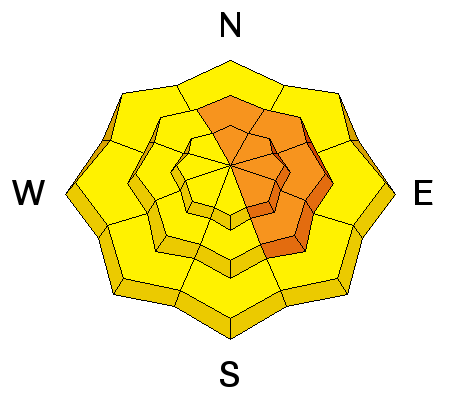
| Advisory: Salt Lake Area Mountains | Issued by Brett Kobernik for Tuesday - February 11, 2014 - 6:39am |
|---|

|
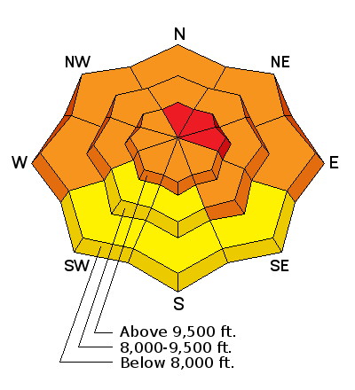
bottom line VERY DANGEROUS AVALANCHE CONDITIONS REMAIN. HUMAN TRIGGERED AVALANCHES ARE LIKELY AGAIN TODAY. Overall there is a CONSIDERABLE avalanche danger but the danger is still HIGH on upper elevation north through east facing slopes. Avoid being on or below slopes of 30 degrees and steeper.
|
 |
special announcement
UDOT WILL BE CONDUCTING AVALANCHE MITIGATION USING EXPLOSIVES IN BIG COTTONWOOD THIS MORNING. A BACKCOUNTRY CLOSURE IS IN EFFECT FOR TERRAIN FROM STAIRS GULCH THROUGH KESSLER AND MILL D SOUTH. THERE WILL BE A BRIEF ROAD CLOSURE AS WELL. ALTA SKI LIFTS WILL BE CONDUCTING AVALANCHE MITIGATION WITH EXPLOSIVES IN THE PATSY MARLEY - WOLVERINE AREA. TERRAIN BETWEEN GRIZZLY GULCH AND CATHERINE'S PASS WILL BE CLOSED THIS MORNING UNTIL THEY ARE DONE. |
 |
current conditions Temperatures dropped into the teens in many locations overnight with partly cloudy skies. Westerly winds slowed since yesterday with light to moderate speeds right now. Riding conditions are fairly decent. |
 |
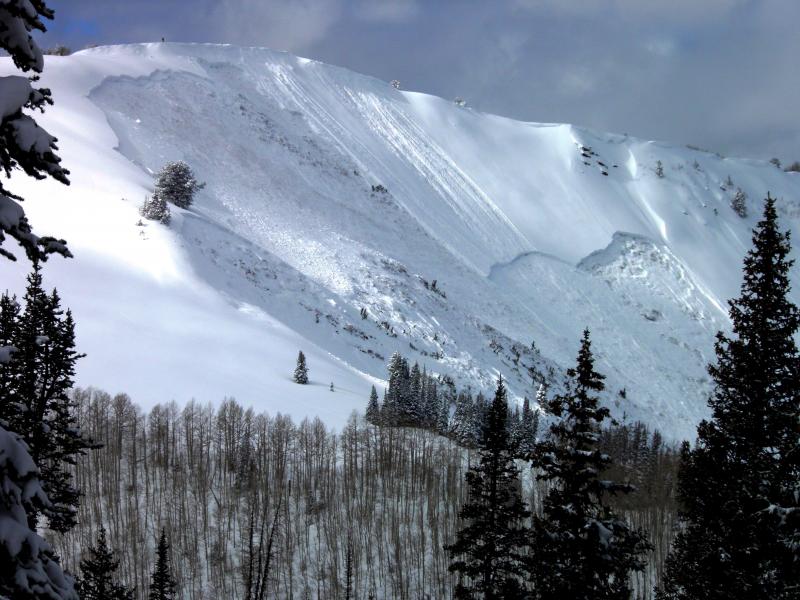
recent activity A few shallow wind slabs were triggered by skiers and snowboarders in Grizzly Gulch on Monday but the most significant avalanche was in West Monitor along the Park City Ridgeline. Skiers dropped a cornice onto the slope which rolled most of the way down before the entire slope collapsed and avalanched big. The fracture line was up to 6 feet deep and the avalanche ran well into the flats below. DETAILS Good visibility allowed for viewing of many avalanches that released during the storm. Check the AVALANCHE LIST for details.
PHOTO: Mark White |
| type | aspect/elevation | characteristics |
|---|

|
|
LIKELIHOOD
 LIKELY
UNLIKELY
SIZE
 LARGE
SMALL
TREND
 INCREASING DANGER
SAME
DECREASING DANGER
|
|
description
Large avalanches breaking into older weak layers is the most dangerous issue today. It's not time to mess with the big slopes. Let the snow settle. Attention Canyoneers: The out of bounds terrain in MacDonalds, Dutches, Squaretop, etc. have similar traits to West Monitor where the cornice had to meander to near the bottom of the slope before it found the sweet spot and went big. |
| type | aspect/elevation | characteristics |
|---|

|
|
LIKELIHOOD
 LIKELY
UNLIKELY
SIZE
 LARGE
SMALL
TREND
INCREASING DANGER
SAME
DECREASING DANGER
|
|
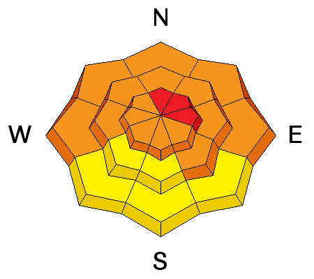
description
Wind slabs that formed on Monday will be less sensitive but still may be touchy. Avoid the lee sides of ridges where the wind has been depositing snow. Keep in mind that wind slabs can form on almost any aspect due to terrain features and localized variations in the wind. |
 |
weather We'll see partly cloudy skies with more clouds during the day. Ridgetop temperatures will get into the low 20s and west wind speeds should remain light to moderate. Another warm storm is going to roll through starting Wednesday but looks like it will mostly favor areas north of the Central Wasatch. We still should see some snow but probably nothing like the last storm depending on how far south the system drifts. We are anticipating quite warm temperatures following the storm. |
| general announcements Remember your information can save lives. If you see anything we should know about, please participate in the creation of our own community avalanche advisory by submitting snow and avalanche conditions. You can also call us at 801-524-5304 or 800-662-4140, email by clicking HERE, or include #utavy in your tweet or Instagram. If you trigger an avalanche in the backcountry - especially if you are adjacent to a ski area – please call the following teams to alert them to the slide and whether anyone is missing or not. Rescue teams can be exposed to significant hazard when responding to avalanches, and do not want to do so when unneeded. Thanks. Salt Lake and Park City – Alta Central (801-742-2033), Canyons Resort Dispatch (435-615-3322) Snowbasin Resort Dispatch (801-620-1017), Powder Mountain Dispatch (801-745-3772 x 123). Sundance Dispatch (801-223-4150) EMAIL ADVISORY We have switched to a new SLC email advisory system. If you would like to get the daily advisory by email, or if you have been getting the advisory by email since the beginning of the season and wish to continue, you will need to subscribe here. DAWN PATROL Hotline updated daily by 5-530am - 888-999-4019 option 8. Twitter Updates for your mobile phone - DETAILS UDOT canyon closures: LINK TO UDOT Utah Avalanche Center mobile app - Get your advisory on your iPhone along with great navigation and rescue tools.uned. Wasatch Powderbird Guides Blog/Itinerary for the Day. Lost or Found something in the backcountry? - http://nolofo.com/ Discount lift tickets are now available at Backcountry.com - Thanks to Ski Utah and the Utah Resorts. All proceeds go towards paying for Utah Avalanche Center avalanche and mountain weather advisories. To those skinning uphill at resorts: it is your responsibility to know the resort policy on uphill travel. Some allow uphill travel and have guidelines, some don't. Contact the Ski Patrol at each resort for details. IMPORTANT: Before skinning at a resort under new snow conditions, check in with Ski Patrol. Resorts can restrict or cut off access if incompatible with control and grooming operations. Benefit the Utah Avalanche Center when you shop from Backcountry.com or REI: Click this link for Backcountry.com or this link to REI, shop, and they will donate a percent of your purchase price to the UAC. Both offer free shipping (with some conditions) so this costs you nothing! Benefit the Utah Avalanche Center when you buy or sell on ebay - set the Utah Avalanche Center as a favorite non-profit in your ebay account here and click on ebay gives when you buy or sell. You can choose to have your seller fees donated to the UAC, which doesn't cost you a penny. This information does not apply to developed ski areas or highways where avalanche control is normally done. This advisory is from the U.S.D.A. Forest Service, which is solely responsible for its content. This advisory describes general avalanche conditions and local variations always exist. |