| During the month of April, Mark Miller will donate $75 to the charity of your choice (5 to chose from, including the Utah Avalanche Center!) Mark Miller Subaru has raised over $300k in the previous 6 Do Good Feel Good events. More Info here |  |
| During the month of April, Mark Miller will donate $75 to the charity of your choice (5 to chose from, including the Utah Avalanche Center!) Mark Miller Subaru has raised over $300k in the previous 6 Do Good Feel Good events. More Info here | |
| Advisory: Salt Lake Area Mountains | Issued by Bruce Tremper for Monday - February 10, 2014 - 6:06am |
|---|

|
bottom line Very dangerous avalanche conditions continue... The danger remains HIGH in most areas of the Wasatch Range at all aspects and elevations. Backcountry travel is not recommended. This includes people leaving ski area exit gates and people recreating in low elevation terrain where your normally don't expect avalanches. Remember avalanches can descend from high above you. Stay off of, and out from underneath, any slope steeper than 30 degrees. We need your help to spread about the HIGH avalanche danger to friends, family, social media - you name it. We don't need any more tragic fatalities.
|
 |
avalanche warning THIS AVALANCHE WARNING IS FOR ALL MOUNTAINS OF NORTHERN AND CENTRAL UTAH. THE LARGEST SNOWSTORM OF THE WINTER HAS OVERLOADED A VERY WEAK PRE-EXISTING SNOWPACK, WHICH HAS CAUSED WIDESPREAD, LARGE AVALANCHES AND TWO FATALITIES OVER THE WEEKEND. A HIGH DANGER CONTINUES FOR ALL ASPECTS AND ELEVATIONS. THIS WARNING DOES NOT INCLUDE SKI AREAS OR HIGHWAYS WHERE AVALANCHE CONTROL IS NORMALLY DONE. |
 |
special announcement Two tragic avalanche fatalities over the weekend. Ashleigh Nicole Cox, 21 was taken off life support yesterday after she was buried by an avalanche in Tibble Fork on Saturday--Preliminary Report. Late yesterday, a snowmobiler, Clint Conover from Ferron, was killed in an avalanche in the Miller Flat area on the Manti Skyline. HERE is a report from the Salt Lake Tribune. Our staff will investigate these accidents and post more details on our website as soon as time allows. From the staff of the Utah Avalanche Center, our hearts go out to the family and friends of these very tragic fatalities. Logan Canyon still closed for avalanche hazard. SR 92 into American Fork Canyon still closed for avalanche hazard. UDOT will conduct avalanche control this morning in Provo Canyon. |
 |
current conditions The last gasp of snow and rain is occurring this morning from, by far, the largest storm of the season. Here are the snow / water equivalent totals so far: Powder Mountain 37" / 4.44" |
 |
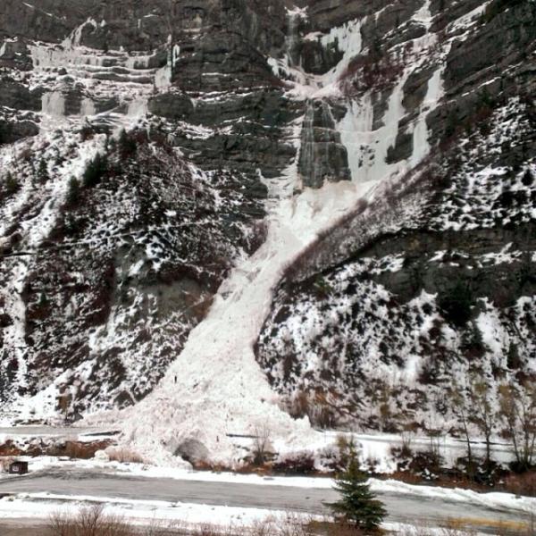
recent activity Yep, the guacamole continued to hit the fan yesterday. Avalanche mitigation work with explosives at the resorts produced extensive, large, deep avalanches at every resort. Bridal Veil Falls in Provo Canyon ran naturally yesterday. Many canyons and roads remained closed due to avalanche hazard and continuing slides across the road--Logan Canyon, Powder Mountain, American Fork Canyon and Sundance. I could go on forever. You get the picture. Natural avalanche at Bridal Veil Falls in Provo Canyon yesterday.
|
| type | aspect/elevation | characteristics |
|---|

|

|
LIKELIHOOD
 LIKELY
UNLIKELY
SIZE
 LARGE
SMALL
TREND
 INCREASING DANGER
SAME
DECREASING DANGER
|
|
description
Many avalanches are breaking within the new snow, either on weak layers within the new snow up to 3 feet deep at all aspects and elevations. Several are running long distances into the valley floor. |
| type | aspect/elevation | characteristics |
|---|

|
|
LIKELIHOOD
 LIKELY
UNLIKELY
SIZE
LARGE
SMALL
TREND
 INCREASING DANGER
SAME
DECREASING DANGER
|
|
description
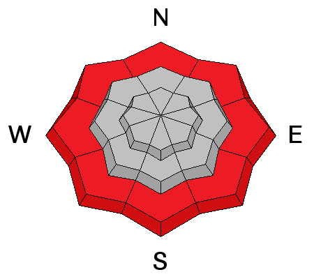
Many of these large, deep avalanches have been breaking on the deep, persistent, weak layers now buried 3-5 feet deep in the snowpack. With such a huge amount of water weight added so quickly, avalanches will find weak layers even on slopes we don't associate with deep slabs, such as south facing slopes. For instance, Highway to Heaven, near Solitude, ran naturally yesterday down to the valley floor, which is a southeast facing slope and broke 3-4' deep and 200' wide. I have also colored in high danger down to low elevations because many of these deep slabs have been running to near their maximum runout distance, often well down into low elevation terrain. |
| type | aspect/elevation | characteristics |
|---|

|
|
LIKELIHOOD
LIKELY
UNLIKELY
SIZE
 LARGE
SMALL
TREND
INCREASING DANGER
SAME
DECREASING DANGER
|
|
description
Rain/snow line reported to 7500' we will continue to get wet avalanches at lower elevations. |
 |
weather The last gasp of rain and snow is occurring this morning and we only expect 1-3 inches of snow in the mountains before it lets off later in the day. Skies should remain cloudy and wind should be light from the northwest. Daytime high should be just below freezing with an overnight low around 17. We have a couple rest days coming up on Tuesday and perhaps Wednesday morning before another cold front arrives Wednesday evening, which could give us about 8 more inches of snow. |
| general announcements
Remember your information can save lives. If you see anything we should know about, please participate in the creation of our own community avalanche advisory by submitting snow and avalanche conditions. You can also call us at 801-524-5304 or 800-662-4140, email by clicking HERE, or include #utavy in your tweet or Instagram. If you trigger an avalanche in the backcountry - especially if you are adjacent to a ski area – please call the following teams to alert them to the slide and whether anyone is missing or not. Rescue teams can be exposed to significant hazard when responding to avalanches, and do not want to do so when unneeded. Thanks. Salt Lake and Park City – Alta Central (801-742-2033), Canyons Resort Dispatch (435-615-3322) Snowbasin Resort Dispatch (801-620-1017), Powder Mountain Dispatch (801-745-3772 x 123). Sundance Dispatch (801-223-4150) EMAIL ADVISORY We have switched to a new SLC email advisory system. If you would like to get the daily advisory by email, or if you have been getting the advisory by email since the beginning of the season and wish to continue, you will need to subscribe here. DAWN PATROL Hotline updated daily by 5-530am - 888-999-4019 option 8. Twitter Updates for your mobile phone - DETAILS UDOT canyon closures: LINK TO UDOT Utah Avalanche Center mobile app - Get your advisory on your iPhone along with great navigation and rescue tools.uned. Wasatch Powderbird Guides Blog/Itinerary for the Day. Lost or Found something in the backcountry? - http://nolofo.com/ Discount lift tickets are now available at Backcountry.com - Thanks to Ski Utah and the Utah Resorts. All proceeds go towards paying for Utah Avalanche Center avalanche and mountain weather advisories. To those skinning uphill at resorts: it is your responsibility to know the resort policy on uphill travel. Some allow uphill travel and have guidelines, some don't. Contact the Ski Patrol at each resort for details. IMPORTANT: Before skinning at a resort under new snow conditions, check in with Ski Patrol. Resorts can restrict or cut off access if incompatible with control and grooming operations. Benefit the Utah Avalanche Center when you shop from Backcountry.com or REI: Click this link for Backcountry.com or this link to REI, shop, and they will donate a percent of your purchase price to the UAC. Both offer free shipping (with some conditions) so this costs you nothing! Benefit the Utah Avalanche Center when you buy or sell on ebay - set the Utah Avalanche Center as a favorite non-profit in your ebay account here and click on ebay gives when you buy or sell. You can choose to have your seller fees donated to the UAC, which doesn't cost you a penny. This information does not apply to developed ski areas or highways where avalanche control is normally done. This advisory is from the U.S.D.A. Forest Service, which is solely responsible for its content. This advisory describes general avalanche conditions and local variations always exist. |