| During the month of April, Mark Miller will donate $75 to the charity of your choice (5 to chose from, including the Utah Avalanche Center!) Mark Miller Subaru has raised over $300k in the previous 6 Do Good Feel Good events. More Info here |  |
| During the month of April, Mark Miller will donate $75 to the charity of your choice (5 to chose from, including the Utah Avalanche Center!) Mark Miller Subaru has raised over $300k in the previous 6 Do Good Feel Good events. More Info here | |
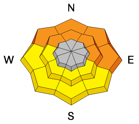
| Advisory: Salt Lake Area Mountains | Issued by Evelyn Lees for Thursday - January 30, 2014 - 7:11am |
|---|

|
bottom line Dangerous avalanche conditions exist - the avalanche danger is CONSIDERABLE on all steep mid and upper elevation slopes and the low elevation northerly facing slopes. Natural avalanches are possible and human-triggered slides likely. Backcountry travel on and below steep slopes should be avoided. People without excellent route finding and snow evaluation skills should stay out of the backcountry. Many Utah ice climbs are in the tracks of avalanche paths, or will be subject to wet sluffs low down.
|
 |
special avalanche bulletin A special avalanche bulletin has been issued for the Wasatch mountains south of I-80, the western Uintas, and the central mountains of Utah including the Manti Skyline…Fish Lake Plateau…and along the I-70 corridor. Rain, snow and strong winds have created a Considerable to High avalanche danger at all elevations. Travel on and below steep slopes is not recommended. |
 |
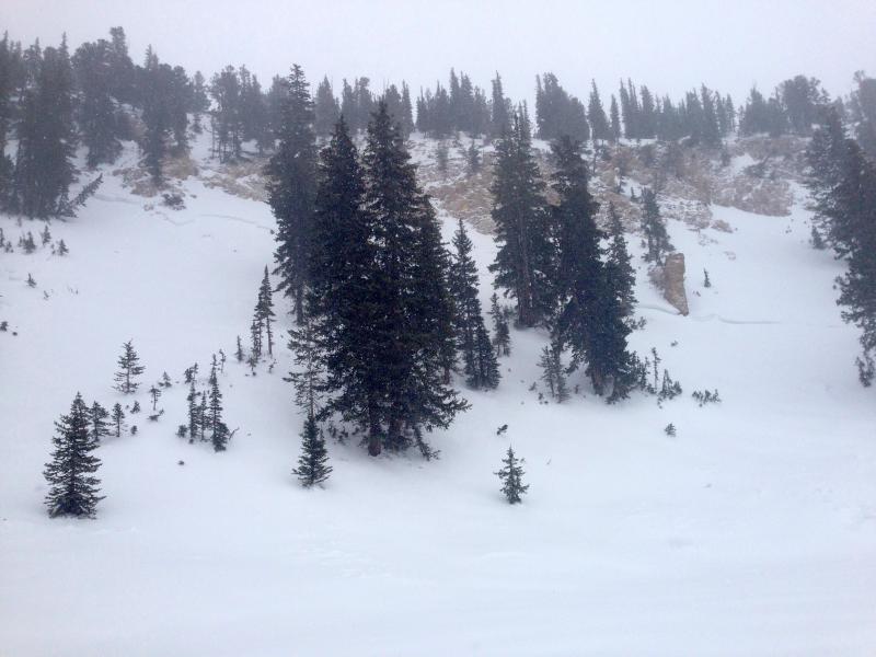
current conditions The cold front blew through northern Utah yesterday evening (about 12 hours ahead of unusually inaccurate computer forecasts) with rain, snow and westerly strong winds. This morning, light snow is continuing to fall, and temperatures are in the teens and twenties. The northwesterly winds are decreasing, with most stations averaging less than 15 mph, with a few high peaks still in the 30s. Storm totals include up to a foot of snow in the Ogden mountains, containing 1 ½ to over 2 ½ inches of water; about 7 to 12 inches of snow in the Cottonwoods, Park City and Provo area mountains, containing 1 to 1 ½ inches of water. |
 |
recent activity There were reports from the Park City ridge line and the Ogden area mountains of sensitive soft wind slabs, both naturals and skier released, up to 2 feet deep, especially along the ridgelines. Wet sluffs could be triggered on steep slopes in uncompacted terrain. Turns out the slide below has been identified as occurring during the January 12/13 slide cycle. – details here.
|
| type | aspect/elevation | characteristics |
|---|

|
|
LIKELIHOOD
 LIKELY
UNLIKELY
SIZE
 LARGE
SMALL
TREND
 INCREASING DANGER
SAME
DECREASING DANGER
|
|
description
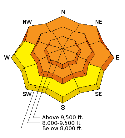
Heavy wet snow and strong winds has created drifts one to three feet deep along the high ridgelines and down into the mid elevation terrain. I expect these drifts to be stubborn and dangerous today, as they may tend to break out above you. The sensitivity of the new snow and these drifts will be very inconsistent depending on the old snow surface – some failing easily, others well bonded. They will look rounded, smooth or wave like, and can be along gully walls, slope break overs and around sub ridges in addition to along the high ridgelines. Cracking on test slopes is a red flag that you are in a dangerous snowpack area. |
| type | aspect/elevation | characteristics |
|---|

|
|
LIKELIHOOD
LIKELY
UNLIKELY
SIZE
LARGE
SMALL
TREND
INCREASING DANGER
SAME
DECREASING DANGER
|
|
description
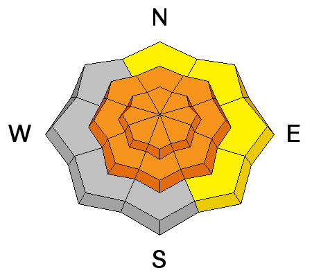
There are multiple buried facet layers. Collapsing is a red flag for any of these weak layers, and slides can be triggered from below or the side. Avoid all aggressive, steep terrain today, and slopes connected to and below steep terrain. Check out a new video tutorial on Persistent Weak Layers.
|
| type | aspect/elevation | characteristics |
|---|

|
|
LIKELIHOOD
LIKELY
UNLIKELY
SIZE
 LARGE
SMALL
TREND
 INCREASING DANGER
SAME
DECREASING DANGER
|
|
description
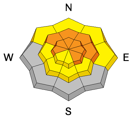
The rain/snow line yesterday averaged over 8,000’, and in some areas was up to 9,800’. The rain soaked snow will take time to cool and wet sluffs and even a few slabs will be easy to trigger on steep slopes in the soggy snow. Wet avalanches will be most widespread on the cold, shady slopes at the lower elevation to mid elevations - avoid terrain traps like gullies and road cuts where the cement like debris could pile up deeply. Wet avalanches are possible along the walls adjacent to ice climbs in the northern Utah mountains. |
 |
weather In the wake of the cold front, skies will be mostly cloudy today, with periods of light snow adding another 2 to 5 inches. Snow fall rates could occasionally reach an inch an hour, especially in areas favored by northwest flow. 10,000’ temperatures will continue to cool today, into the mid-teens, with 8’000’ highs in the upper 20s. The northwesterly winds will continue to decrease through the morning, with ridgeline speeds ending up in the 15 to 25 mph range, with gusts in the 30s. Periods of snow will continue in the mountains through Saturday, adding another few inches each 12 hours. |
| general announcements Remember your information can save lives. If you see anything we should know about, please participate in the creation of our own community avalanche advisory by submitting snow and avalanche conditions. You can also call us at 801-524-5304 or 800-662-4140, email by clicking HERE, or include #utavy in your tweet or Instagram. If you trigger an avalanche in the backcountry - especially if you are adjacent to a ski area – please call the following teams to alert them to the slide and whether anyone is missing or not. Rescue teams can be exposed to significant hazard when responding to avalanches, and do not want to do so when unneeded. Thanks. Salt Lake and Park City – Alta Central (801-742-2033), Canyons Resort Dispatch (435-615-3322) Snowbasin Resort Dispatch (801-620-1017), Powder Mountain Dispatch (801-745-3772 x 123). Sundance Dispatch (801-223-4150) EMAIL ADVISORY We have switched to a new SLC email advisory system. If you would like to get the daily advisory by email, or if you have been getting the advisory by email since the beginning of the season and wish to continue, you will need to subscribe here. DAWN PATROL Hotline updated daily by 5-530am - 888-999-4019 option 8. Twitter Updates for your mobile phone - DETAILS UDOT canyon closures: LINK TO UDOT Utah Avalanche Center mobile app - Get your advisory on your iPhone along with great navigation and rescue tools.uned. Wasatch Powderbird Guides Blog/Itinerary for the Day. Lost or Found something in the backcountry? - http://nolofo.com/ Discount lift tickets are now available at Backcountry.com - Thanks to Ski Utah and the Utah Resorts. All proceeds go towards paying for Utah Avalanche Center avalanche and mountain weather advisories. To those skinning uphill at resorts: it is your responsibility to know the resort policy on uphill travel. Some allow uphill travel and have guidelines, some don't. Contact the Ski Patrol at each resort for details. IMPORTANT: Before skinning at a resort under new snow conditions, check in with Ski Patrol. Resorts can restrict or cut off access if incompatible with control and grooming operations. Benefit the Utah Avalanche Center when you shop from Backcountry.com or REI: Click this link for Backcountry.com or this link to REI, shop, and they will donate a percent of your purchase price to the UAC. Both offer free shipping (with some conditions) so this costs you nothing! Benefit the Utah Avalanche Center when you buy or sell on ebay - set the Utah Avalanche Center as a favorite non-profit in your ebay account here and click on ebay gives when you buy or sell. You can choose to have your seller fees donated to the UAC, which doesn't cost you a penny. This information does not apply to developed ski areas or highways where avalanche control is normally done. This advisory is from the U.S.D.A. Forest Service, which is solely responsible for its content. This advisory describes general avalanche conditions and local variations always exist. |