| During the month of April, Mark Miller will donate $75 to the charity of your choice (5 to chose from, including the Utah Avalanche Center!) Mark Miller Subaru has raised over $300k in the previous 6 Do Good Feel Good events. More Info here |  |
| During the month of April, Mark Miller will donate $75 to the charity of your choice (5 to chose from, including the Utah Avalanche Center!) Mark Miller Subaru has raised over $300k in the previous 6 Do Good Feel Good events. More Info here | |
| Advisory: Salt Lake Area Mountains | Issued by Brett Kobernik for Monday - January 20, 2014 - 6:45am |
|---|

|
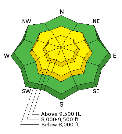
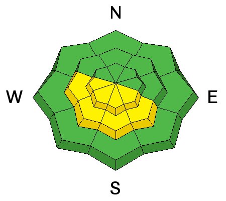
bottom line The overall avalanche danger is MODERATE. Human triggered avalanches are possible. You may still be able to trigger a dangerous persistent slab avalanche on slopes of 35 degrees and steeper above around 9000 feet that face northwest through northeast through southeast. The danger of wet loose snow avalanches on sunny slopes will increase with daytime heating. Be careful not to be in the wrong place at the wrong time.
|
 |
current conditions High pressure continues. Overnight ridgetop temperatures were in the mid 20s. There is a little wind along the higher ridges with some moderate speed hourly averages. The mid elevation ridges have fairly light speeds. The wind direction is generally west. You will find almost every type of snow surface condition out there today. Good riding can be found in the sheltered areas with re-crystalized surface snow. This is also known as 'near surface faceting'. I've found areas with thin wind crusts that are starting to break down due to this process. During high pressure, the minds of avalanche forecasters start to wander. Drew was on a few tangents yesterday, I'm on another today. I've been looking at total snow depths and where we sit as far as average for the season. At the Alta Guard, I roughly estimate that they've recorded around 54 inches of snow in January. Average in January is 94 inches. We have some catching up to do by the end of the month. Seems unlikely that we'll make average given the current weather outlook. Also at the Guard, average combined snowfall totals for November, December and January are 257 inches. As of now, a rough total for this year is 140 inches. Most Snotel sites around the central Wasatch are well under average for this time of the season as well. I've noticed many people digging snowpits to the ground still. It's quite easy to do still with the shallow snowpack. Many years, we are not digging to the ground anymore at this time of the season. Step off your skis, snowshoes, snowboards or snowmobiles in many locations and your foot will go through right to the ground. This all equates to an abundance of faceted weak snow. A lot of locations are not unstable at this time. It's just ALL weak snow. But, we are set up for a significant avalanche cycle if we ever get a serious storm. |
 |
recent activity There was a little wet loose avalanche activity reported from yesterday on the sunny aspects. None of the avalanches were all that noteworthy. |
| type | aspect/elevation | characteristics |
|---|

|
|
LIKELIHOOD
 LIKELY
UNLIKELY
SIZE
 LARGE
SMALL
TREND
 INCREASING DANGER
SAME
DECREASING DANGER
|
|
description
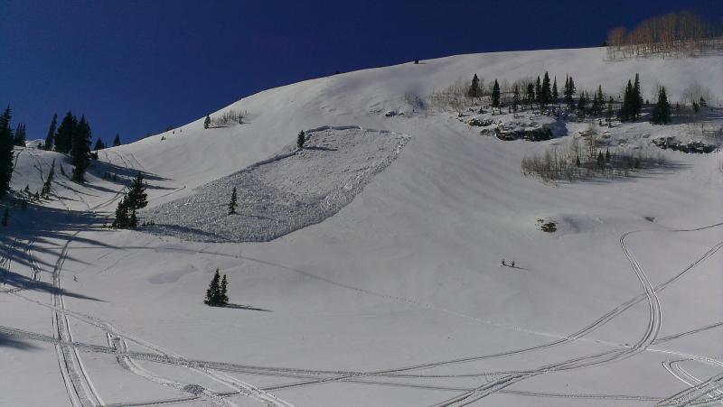
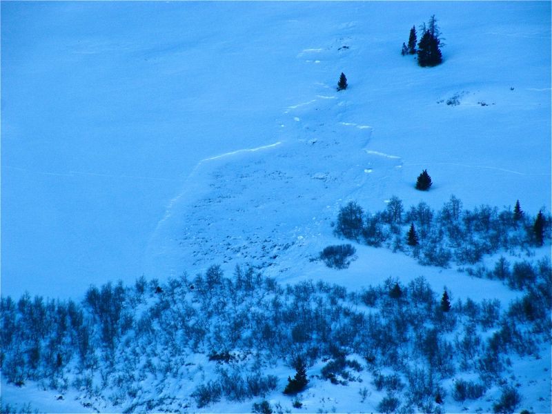
The biggest avalanche threat out there today remains the chance of triggering an avalanche that breaks into old weak sugary snow. As time goes on, it is less likely that a person will trigger one but it is still a distinct possibility. Shallower locations are probably the most likely spots. A number of these persistent slab avalanches pulled out mid way down the slope. The upper portions of many slopes have stout wind crusts and wind slabs that formed before our last big storm. These are giving the snowpack strength over the buried weak snow. We didn't load the slopes with enough snow for these to break. But, get down the slope a bit where the buried wind crusts and wind slabs are not as pronounced and it seems they may be easier to trigger. (Photos: Left, No No Name - sled triggered 1-18. Right, UFO Bowls - natural 1-12)
|
| type | aspect/elevation | characteristics |
|---|

|
|
LIKELIHOOD
LIKELY
UNLIKELY
SIZE
 LARGE
SMALL
TREND
 INCREASING DANGER
SAME
DECREASING DANGER
|
|
description
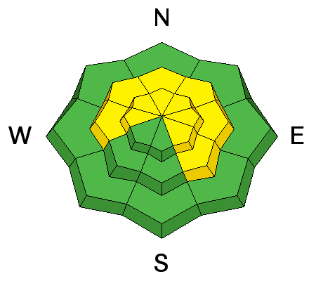
Wet loose snow avalanching is again worth a mention today. If you are on sun exposed slopes mid day, be cautious about what kind of terrain you are on. Avoid confined gullies and terrain traps where any wet loose snow avalanche debris may wind up. |
 |
weather It'll be another very nice day to be up in the mountains with daytime highs in the 30s and 40s. Light to moderate westerly winds should shift more north as the day progresses and slow in speed late in the day. High pressure continues through mid week producing benign weather. It looks like there will be a little disturbance around Thursday that probably won't do much for us. There is a little more hopeful change in the patter around the beginning of February. |
| general announcements
This information does not apply to developed ski areas or highways where avalanche control is normally done. This advisory is from the U.S.D.A. Forest Service, which is solely responsible for its content. This advisory describes general avalanche conditions and local variations always exist. If you trigger an avalanche in the backcountry - especially if you are adjacent to a ski area – please call the following teams to alert them to the slide and whether anyone is missing or not. Rescue teams can be exposed to significant hazard when responding to avalanches, and do not want to do so when unneeded. Thanks. Salt Lake and Park City – Alta Central (801-742-2033), Canyons Resort Dispatch (435-615-3322) Snowbasin Resort Dispatch (801-620-1017), Powder Mountain Dispatch (801-745-3772 x 123). Sundance Dispatch (801-223-4150) EMAIL ADVISORY Get the Salt Lake avalanche advisory emailed to you every morning. CLICK HERE FOR DETAILS DAWN PATROL Hotline updated daily by 5-530am - 888-999-4019 option 8. Twitter Updates for your mobile phone - DETAILS UDOT canyon closures: LINK TO UDOT Utah Avalanche Center mobile app - Get your advisory on your iPhone along with great navigation and rescue tools.uned. Wasatch Powderbird Guides Blog/Itinerary for the Day. Lost or Found something in the backcountry? - http://nolofo.com/ Discount lift tickets are now available at Backcountry.com - Thanks to Ski Utah and the Utah Resorts. All proceeds go towards paying for Utah Avalanche Center avalanche and mountain weather advisories. To those skinning uphill at resorts: it is your responsibility to know the resort policy on uphill travel. Some allow uphill travel and have guidelines, some don't. Contact the Ski Patrol at each resort for details. IMPORTANT: Before skinning at a resort under new snow conditions, check in with Ski Patrol. Resorts can restrict or cut off access if incompatible with control and grooming operations. Benefit the Utah Avalanche Center when you shop from Backcountry.com or REI: Click this link for Backcountry.com or this link to REI, shop, and they will donate a percent of your purchase price to the UAC. Both offer free shipping (with some conditions) so this costs you nothing! Benefit the Utah Avalanche Center when you buy or sell on ebay - set the Utah Avalanche Center as a favorite non-profit in your ebay account here and click on ebay gives when you buy or sell. You can choose to have your seller fees donated to the UAC, which doesn't cost you a penny. Remember your information can save lives. If you see anything we should know about, please participate in the creation of our own community avalanche advisory by submitting snow and avalanche conditions. You can also call us at 801-524-5304 or 800-662-4140, email by clicking HERE, or include #utavy in your tweet or Instagram. |