| During the month of April, Mark Miller will donate $75 to the charity of your choice (5 to chose from, including the Utah Avalanche Center!) Mark Miller Subaru has raised over $300k in the previous 6 Do Good Feel Good events. More Info here |  |
| During the month of April, Mark Miller will donate $75 to the charity of your choice (5 to chose from, including the Utah Avalanche Center!) Mark Miller Subaru has raised over $300k in the previous 6 Do Good Feel Good events. More Info here | |
| Advisory: Salt Lake Area Mountains | Issued by Drew Hardesty for Sunday - January 12, 2014 - 5:37am |
|---|

|
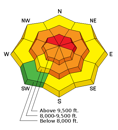
bottom line Areas of HIGH DANGER exist in the backcountry right now. With additional snow and wind, I'm expecting more natural avalanches to occur, with human triggered slides likely 2-4' deep on many slopes on the north through east side of the compass. Avalanches may be triggered at a distance or from below...with any slide potentially stepping down more deeply, creating unsurvivable avalanche conditions. Expert backcountry travelers will head to the mid-elevation slopes well less than 35 degrees in steepness today. Seeking steep terrain with the new powder? Head to one of our world class mountain resorts.
|
 |
avalanche warning THIS AVALANCHE WARNING IS FOR THE MOUNTAINS OF NORTHERN AND CENTRAL UTAH, TO INCLUDE THE WESTERN UINTA MOUNTAINS. VERY DANGEROUS AVALANCHE CONDITIONS EXIST THROUGH THE WEEKEND...AVOID BEING ON OR BENEATH STEEP MOUNTAIN SLOPES...AS AVALANCHES MAY BE TRIGGERED LOW ON THE SLOPE AS WELL.
|
 |
special announcement UDOT Little Cottonwood will be conducting avalanche control work this morning. The Hellgate Superior portion of the road will close at 0530. Hwy 210 will close above Snowbird Entry 1 at 0630. Interlodge, in the Town of Alta and portions of Snowbird, will begin at 0645. Backcountry closures to the north side of the canyon (everything in red below) between Monte Cristo and Grizzly Gulch is in effect. |
 |
current conditions Wind and more wind.
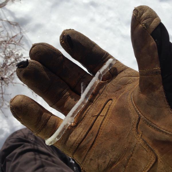
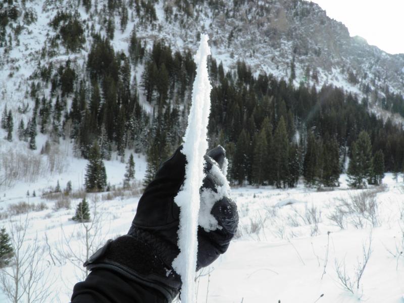
The west to southwesterly winds picked up again yesterday afternoon ahead of the current storm, blowing 25-30mph with gusts to 40. They veered to the northwest overnight but haven't missed a beat. Currently, the most exposed anemometers are blowing 40-50 with gusts near 80 with mid-canyon gusts in the 30s. Temperatures have fallen with the cold front and are now in the mid teens and low 20s. There's some snow involved in there somewhere as well - most areas have already picked up 2-5" of mostly graupel in the wee hours this morning, though it won't sit for long before being transported to somewhere else. Anyone notice a rime crust out there yesterday? One observer noted the chain of weather events - "From the best I could tell it looked like a wind event followed by grauple and then freezing rain accompanied by a wind from the west." It ain't pretty, but it's ours to keep. (photos JB/Mark White)
|
 |
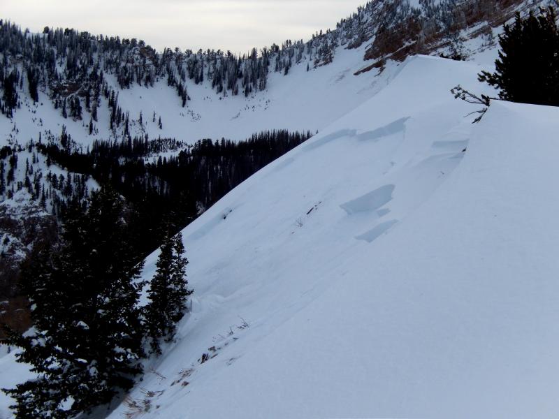
recent activity To be honest, I'm a little shocked. We only heard about a few human triggered slides yesterday...but I would've expected more. Friday's winds certainly tipped the balance toward natural activity (Raymond, Cardiac Bowl, Ivory Flakes, Main Days, Depth Hoar Bowl, Tuscarora, Sunset, etc) - most of these north through east facing - yet we only heard about a few human triggered slides yesterday. Perhaps the rime crust and wind and Avalanche Warning kept folks at bay. We'll see. Still, those that were triggered were significant -
|
| type | aspect/elevation | characteristics |
|---|

|
|
LIKELIHOOD
 LIKELY
UNLIKELY
SIZE
 LARGE
SMALL
TREND
 INCREASING DANGER
SAME
DECREASING DANGER
|
|
description
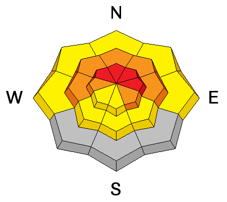
Continued "loading" through snow and wind or just wind will again keep many slopes poised to avalanche, particularly with a trigger. Weak interfaces from late October/early November near the ground as well as from late November/early December will be prone to failure today. Again, these are not run-of-the-mill avalanches - these keep pros on their toes - usually through ridgewalking or complete avoidance all together. Remember that these can be triggered remotely and with a stiffening slab and wild card rime crust, these avalanches may propagate wildly and across terrain features. In other words -
The take-home - AVOID BEING ON, ADJACENT TO, OR BENEATH STEEP WIND DRIFTED SLOPES, PARTICULARLY IF THEY FACE NORTHWEST TO EAST TO SOUTHEAST. These may also be triggered mid-slope,areas that held the weakest snow.... I do expect "repeater" avalanches. With so much weak faceted snow near the ground and in the mid-pack, avalanches will have a hard time "cleaning out all the junk" in the closet...instead they'll reload...and then pull out again on the remaining weak faceted sugary snow. |
| type | aspect/elevation | characteristics |
|---|

|
|
LIKELIHOOD
LIKELY
UNLIKELY
SIZE
 LARGE
SMALL
TREND
 INCREASING DANGER
SAME
DECREASING DANGER
|
|
description
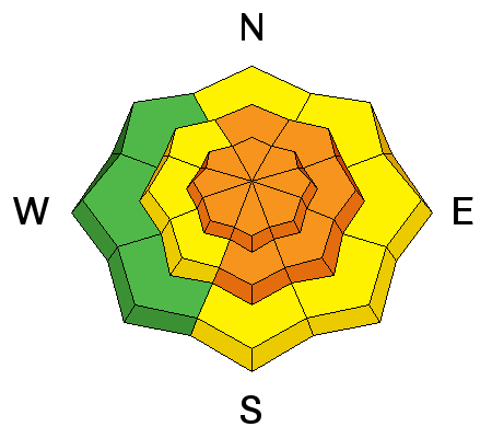
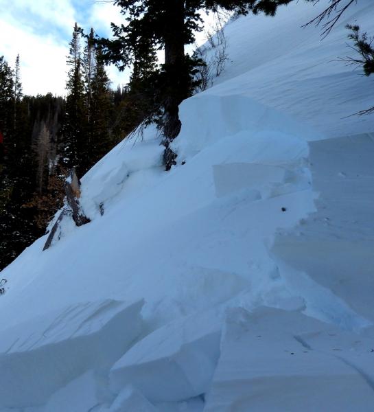
Wind drifts up to - easily - a couple feet deep may be triggered in many steep slopes on a variety of aspects and elevations. I've been fooled before thinking that a rime crust would cap and stave off any wind drifting; instead the winds eroded the crust down and then pulled out the snow beneath. So drifting may also be triggered well off the ridgelines and then have the potential to step down into older faceted snow to the ground. The newest drifts from last night and today will be the most sensitive, may collapse Friday night's crust and propagate further. Still, avoid the smooth, rounded, pillowy drifts on the steeper terrain - note their appearance in Bill Nalli's photo from yesterday - Also avoid mid-slope breakovers, cross-loaded gullies, and any area- even mid-elevation- where there may be a convexity that allows for wind drifting.
|
| type | aspect/elevation | characteristics |
|---|

|
|
LIKELIHOOD
 LIKELY
UNLIKELY
SIZE
LARGE
SMALL
TREND
INCREASING DANGER
SAME
DECREASING DANGER
|
|
description
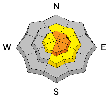
ALSO - LARGE CORNICES MAY BE TRIGGERED AT A DISTANCE AND ARE LIKELY TO PULL FURTHER BACK ALONG THE RIDGELINE THAN EXPECTED....Don't go over with one of these boxcars - you and the cornice are likely to trigger a slide on the slope below (photo Paradis)
|
 |
weather This system will continue to produce snowfall through tomorrow with 6-10" possible in favored locations. Confidence level in snow amounts is low, confidence level of winds is high. Winds will remain northwesterly, blowing 25-35mph along the ridgelines with higher hourly averages in the high alpine. Temps will be in the teens. The storm barrels on to the east late Monday with high pressure building through the week and mountain temps heading for spring... |
| general announcements
This information does not apply to developed ski areas or highways where avalanche control is normally done. This advisory is from the U.S.D.A. Forest Service, which is solely responsible for its content. This advisory describes general avalanche conditions and local variations always occur. If you trigger an avalanche in the backcountry - especially if you are adjacent to a ski area – please call the following teams to alert them to the slide and whether anyone is missing or not. Rescue teams can be exposed to significant hazard when responding to avalanches, and do not want to do so when unneeded. Thanks. Salt Lake and Park City – Alta Central (801-742-2033), Canyons Resort Dispatch (435-615-3322) Snowbasin Resort Dispatch (801-620-1017), Powder Mountain Dispatch (801-745-3772 x 123). Sundance Dispatch (801-231-4150) EMAIL ADVISORY Get the Salt Lake avalanche advisory emailed to you every morning. CLICK HERE FOR DETAILS DAWN PATROL Hotline updated daily by 5-530am - 888-999-4019 option 8. Twitter Updates for your mobile phone - DETAILS UDOT canyon closures: LINK TO UDOT Utah Avalanche Center mobile app - Get your advisory on your iPhone along with great navigation and rescue tools.uned. Wasatch Powderbird Guides Blog/Itinerary for the Day. They'll be up and running later this winter - Lost or Found something in the backcountry? - http://nolofo.com/ Discount lift tickets are now available at Backcountry.com - Thanks to Ski Utah and the Utah Resorts. All proceeds go towards paying for Utah Avalanche Center avalanche and mountain weather advisories. To those skinning uphill at resorts: it is your responsibility to know the resort policy on uphill travel. Some allow uphill travel and have guidelines, some don't. Contact the Ski Patrol at each resort for details. IMPORTANT: Before skinning at a resort under new snow conditions, check in with Ski Patrol. Resorts can restrict or cut off access if incompatible with control and grooming operations. Benefit the Utah Avalanche Center when you shop from Backcountry.com or REI: Click this link for Backcountry.com or this link to REI, shop, and they will donate a percent of your purchase price to the UAC. Both offer free shipping (with some conditions) so this costs you nothing! Benefit the Utah Avalanche Center when you buy or sell on ebay - set the Utah Avalanche Center as a favorite non-profit in your ebay account here and click on ebay gives when you buy or sell. You can choose to have your seller fees donated to the UAC, which doesn't cost you a penny. Remember your information can save lives. If you see anything we should know about, please participate in the creation of our own community avalanche advisory by submitting snow and avalanche conditions. You can also call us at 801-524-5304 or 800-662-4140, email by clicking HERE, or include #utavy in your tweet or Instagram. Ski Utah mobile snow updates: |


.jpg)