
| During the month of April, Mark Miller will donate $75 to the charity of your choice (5 to chose from, including the Utah Avalanche Center!) Mark Miller Subaru has raised over $300k in the previous 6 Do Good Feel Good events. More Info here |  |
| During the month of April, Mark Miller will donate $75 to the charity of your choice (5 to chose from, including the Utah Avalanche Center!) Mark Miller Subaru has raised over $300k in the previous 6 Do Good Feel Good events. More Info here | |
| Advisory: Salt Lake Area Mountains | Issued by Evelyn Lees for Thursday - January 9, 2014 - 6:59am |
|---|

|
bottom line It is a day of increasing avalanche danger. This morning’s MODERATE avalanche danger will increase to CONSIDERABLE this afternoon, with heavier snowfall and stronger winds.
Solution: once again back off the steep slopes, and enjoy the lower angle slopes where the great powder is filling in the old tracks.
|
 |
special announcement Thursday, January 9th, 7:30pm in SLC/Black Diamond store - As with the style of a "fireside chat", Drew Hardesty will be talking about a number of informal topics, including current conditions, avalanche problems and associated travel recommendations. Thursday, January 9th, 6pm - Wildflower Lounge, Snowbird - Utah Adventure Speaker Series presents Noah Howell (co-founder of Powderwhore Productions) talks about backcountry skiing adventures. |
 |
current conditions Skies are cloudy this morning, and light snow is starting to fall in some areas. Temperatures are in the teens to low 20s, and for a short lived period, the southwesterly winds are light. Most stations are averaging less than 10 mph, with the high peaks in the 15 to 20 mph range, gusting into the low 30s. Snow totals from yesterday’s little storm – 5 to 10” in the Cottonwoods, with upper Little receiving the highest numbers, 1 to 4” in the Ogden and Park City mountains, and about 2” reported from the mid elevation stations in the Provo area mountains. |
 |
recent activity As the snow added up yesterday afternoon, both sluffs and a few very shallow soft slabs were reported, generally from slope cuts. Most were failing within the new snow, with a few breaking into loose surface facets. |
| type | aspect/elevation | characteristics |
|---|

|
|
LIKELIHOOD
 LIKELY
UNLIKELY
SIZE
 LARGE
SMALL
TREND
 INCREASING DANGER
SAME
DECREASING DANGER
|
|
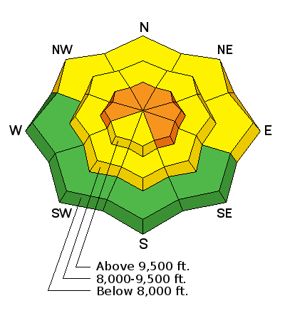
description
New snow soft slab avalanches and loose snow sluffs will be the most widespread avalanche activity today. The sensitivity of the snow will dramatically increase this afternoon, as snow fall rates and winds intensify. Be alert for periods of heavy snowfall – this is when the snow will be the most reactive, and slides will be easiest to trigger, with a few naturals possible. New snow avalanches are possible on steep slopes of all aspects. |
| type | aspect/elevation | characteristics |
|---|

|
|
LIKELIHOOD
LIKELY
UNLIKELY
SIZE
LARGE
SMALL
TREND
INCREASING DANGER
SAME
DECREASING DANGER
|
|
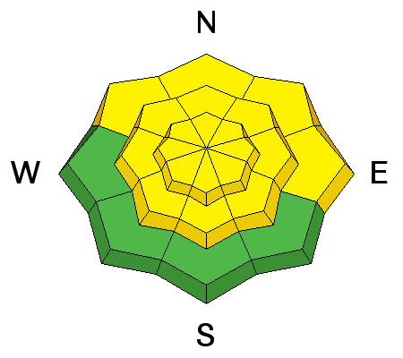
description
The increasing winds today through tonight will have abundant new snow to drift, layering it into dense, cracky slabs that will be easily triggered. The higher you go in elevation, the deeper and more widespread the wind drifts will be, especially on slopes facing the east ½ of the compass. Also watch for drifting in exposed mid elevation terrain, along gully walls, around sub-ridges and at mid-slope break overs. |
| type | aspect/elevation | characteristics |
|---|

|
|
LIKELIHOOD
 LIKELY
UNLIKELY
SIZE
 LARGE
SMALL
TREND
INCREASING DANGER
SAME
DECREASING DANGER
|
|
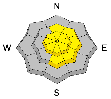
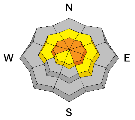
description
Periods of snow during the next 4 days will slowly tip the balance on the multiple layers of buried weak faceted snow. Today, the most likely scenario would be a step down – where the weight of a smaller new snow slide or sluff triggers a much deeper, wider slide. These would be high consequence, with a long ride and full burial likely. Weak faceted snow exists on most aspects and elevations. |
 |
weather Light snow will start to fall this morning, and become heavy this afternoon behind the cold front. Snowfall rates may reach 2” per hour, and totals of 5 to 9” are expected by evening, with locally higher amounts possible. Winds will shift to a more northwesterly direction after the frontal passage, and increase throughout the day. Ridgelines will have 20 to 30 mph averages, with gusts in the 40s. 10,000’ temperatures will remain in the mid-teens. Stormy weather will continue through much of the weekend – moderate to strong northwesterly winds tonight, and additional few inches of denser snow Friday, warmer and windy Saturday, followed by a potentially vigorous storm on Saturday night into Sunday. |
| general announcements This information does not apply to developed ski areas or highways where avalanche control is normally done. This advisory is from the U.S.D.A. Forest Service, which is solely responsible for its content. This advisory describes general avalanche conditions and local variations always occur. If you trigger an avalanche in the backcountry - especially if you are adjacent to a ski area – please call the following teams to alert them to the slide and whether anyone is missing or not. Rescue teams can be exposed to significant hazard when responding to avalanches, and do not want to do so when unneeded. Thanks. Salt Lake and Park City – Alta Central (801-742-2033), Canyons Resort Dispatch (435-615-3322) Snowbasin Resort Dispatch (801-620-1017), Powder Mountain Dispatch (801-745-3772 x 123). Sundance Dispatch (801-231-4150) EMAIL ADVISORY Get the Salt Lake avalanche advisory emailed to you every morning. CLICK HERE FOR DETAILS DAWN PATROL Hotline updated daily by 5-530am - 888-999-4019 option 8. Twitter Updates for your mobile phone - DETAILS UDOT canyon closures: LINK TO UDOT Utah Avalanche Center mobile app - Get your advisory on your iPhone along with great navigation and rescue tools.uned. Wasatch Powderbird Guides Blog/Itinerary for the Day. They'll be up and running later this winter - Lost or Found something in the backcountry? - http://nolofo.com/ Discount lift tickets are now available at Backcountry.com - Thanks to Ski Utah and the Utah Resorts. All proceeds go towards paying for Utah Avalanche Center avalanche and mountain weather advisories. To those skinning uphill at resorts: it is your responsibility to know the resort policy on uphill travel. Some allow uphill travel and have guidelines, some don't. Contact the Ski Patrol at each resort for details. IMPORTANT: Before skinning at a resort under new snow conditions, check in with Ski Patrol. Resorts can restrict or cut off access if incompatible with control and grooming operations. Benefit the Utah Avalanche Center when you shop from Backcountry.com or REI: Click this link for Backcountry.com or this link to REI, shop, and they will donate a percent of your purchase price to the UAC. Both offer free shipping (with some conditions) so this costs you nothing! Benefit the Utah Avalanche Center when you buy or sell on ebay - set the Utah Avalanche Center as a favorite non-profit in your ebay account here and click on ebay gives when you buy or sell. You can choose to have your seller fees donated to the UAC, which doesn't cost you a penny. Remember your information can save lives. If you see anything we should know about, please participate in the creation of our own community avalanche advisory by submitting snow and avalanche conditions. You can also call us at 801-524-5304 or 800-662-4140, email by clicking HERE, or include #utavy in your tweet or Instagram. Ski Utah mobile snow updates: |


