| During the month of April, Mark Miller will donate $75 to the charity of your choice (5 to chose from, including the Utah Avalanche Center!) Mark Miller Subaru has raised over $300k in the previous 6 Do Good Feel Good events. More Info here |  |
| During the month of April, Mark Miller will donate $75 to the charity of your choice (5 to chose from, including the Utah Avalanche Center!) Mark Miller Subaru has raised over $300k in the previous 6 Do Good Feel Good events. More Info here | |
| Advisory: Salt Lake Area Mountains | Issued by Drew Hardesty for Friday - January 3, 2014 - 6:22am |
|---|

|
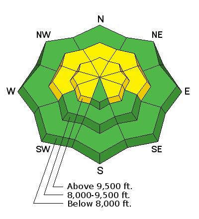
bottom line A MODERATE danger exists on mid and upper elevation, west through north through easterly facing slopes. Large avalanches are possible in isolated areas. Low probability, high consequence. What's your level of acceptable risk? Also don't overlook the recent wind-drifting - continue to avoid the smooth, rounded recent deposits of wind drifted snow above about 9500' (on primarily north through east through southeast facing slopes).
|
 |
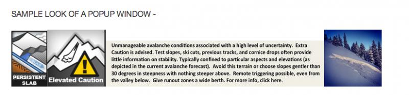
special announcement This fall, Wendy Wagner from the Chugach Avalanche Center in Alaska and I started working on travel recommendations/advice for each of the Avalanche Problems associated with the avalanche forecast. We're looking for your feedback - read on - (Draft example below/Zach Grant photo)
|
 |
current conditions Skies are clear, ain't it a shame. Temps are in the mid to upper 20s and the winds picked up a touch overnight and are blowing from the west at 15-20mph. Along the most exposed ridgelines, anemometers hum at 25-30mph. Riding conditions remain the same as yesterday, if not moreso. Snowshoeing and snowmobiling conditions are challenging with unsupportable cohesionless snow and thinly buried obstacles in many mid and low elevation areas...best to stick to packed out trails and groomed/packed roads.
|
 |
recent activity Our last significant activity was in lockstep with our last storms on the 19-23rd...with, as one would expect, a few pockets triggered here and there through Christmas. |
| type | aspect/elevation | characteristics |
|---|

|
|
LIKELIHOOD
 LIKELY
UNLIKELY
SIZE
 LARGE
SMALL
TREND
 INCREASING DANGER
SAME
DECREASING DANGER
|
|
description
This may be one of those years.
(Drawing - Mike Clelland; recently released Allen & Mike's Avalanche Book...of the Allen and Mike's series) Lacking recent avalanche activity and obvious clues such as cracking or collapsing, we then have to pull out the shovel to look for Structural Weaknesses in the Snowpack. Our own Salt Lake City researcher and educator Ian McCammon and the Swiss researcher Jurg Schweizer produced a wonderful paper in 2002 outlining "lemons" or red flags when looking at the overall structure of the snow. Recently, SLC local Dylan Freed, AK heli-ski guide and avalanche educator, distilled the 5 lemons down to 3 (PHD) for efficiency and his students to more readily grasp. They include -
This is why/how Logan avalanche forecaster Toby Weed and his partner assessed - and then backed off some terrain yesterday. See his ob from yesterday. |
 |
weather Clear skies will give way to increasing clouds ahead of a going through the motions storm, expected to arrive late afternoon/early evening. The northwest winds will increase to hourly averages of 30-40mph along the exposed ridgelines and more pronounced along the 11,000' ridgelines and areas north of I-80. Today's highs at 10k of near 30 will drop to the mid-teens tomorrow. Snow? 2-4" if we're lucky. The ridge rebuilds for Sunday into early next week with - a change in the weather pattern for Tuesday through the weekend. No, the storms don't look all that impressive; though they'll add a bit of a refresher and keep the valley smog at bay. |
| general announcements
This information does not apply to developed ski areas or highways where avalanche control is normally done. This advisory is from the U.S.D.A. Forest Service, which is solely responsible for its content. This advisory describes general avalanche conditions and local variations always occur. If you trigger an avalanche in the backcountry - especially if you are adjacent to a ski area – please call the following teams to alert them to the slide and whether anyone is missing or not. Rescue teams can be exposed to significant hazard when responding to avalanches, and do not want to do so when unneeded. Thanks. Salt Lake and Park City – Alta Central (801-742-2033), Canyons Resort Dispatch (435-615-3322) Snowbasin Resort Dispatch (801-620-1017), Powder Mountain Dispatch (801-745-3772 x 123). Sundance Dispatch (801-231-4150) EMAIL ADVISORY Get the Salt Lake avalanche advisory emailed to you every morning. CLICK HERE FOR DETAILS DAWN PATROL Hotline updated daily by 5-530am - 888-999-4019 option 8. Twitter Updates for your mobile phone - DETAILS UDOT canyon closures: LINK TO UDOT Utah Avalanche Center mobile app - Get your advisory on your iPhone along with great navigation and rescue tools.uned. Wasatch Powderbird Guides Blog/Itinerary for the Day. They'll be up and running later this winter - Lost or Found something in the backcountry? - http://nolofo.com/ Discount lift tickets are now available at Backcountry.com - Thanks to Ski Utah and the Utah Resorts. All proceeds go towards paying for Utah Avalanche Center avalanche and mountain weather advisories. To those skinning uphill at resorts: it is your responsibility to know the resort policy on uphill travel. Some allow uphill travel and have guidelines, some don't. Contact the Ski Patrol at each resort for details. IMPORTANT: Before skinning at a resort under new snow conditions, check in with Ski Patrol. Resorts can restrict or cut off access if incompatible with control and grooming operations. Benefit the Utah Avalanche Center when you shop from Backcountry.com or REI: Click this link for Backcountry.com or this link to REI, shop, and they will donate a percent of your purchase price to the UAC. Both offer free shipping (with some conditions) so this costs you nothing! Benefit the Utah Avalanche Center when you buy or sell on ebay - set the Utah Avalanche Center as a favorite non-profit in your ebay account here and click on ebay gives when you buy or sell. You can choose to have your seller fees donated to the UAC, which doesn't cost you a penny. Remember your information can save lives. If you see anything we should know about, please participate in the creation of our own community avalanche advisory by submitting snow and avalanche conditions. You can also call us at 801-524-5304 or 800-662-4140, email by clicking HERE, or include #utavy in your tweet or Instagram. Ski Utah mobile snow updates: |