| During the month of April, Mark Miller will donate $75 to the charity of your choice (5 to chose from, including the Utah Avalanche Center!) Mark Miller Subaru has raised over $300k in the previous 6 Do Good Feel Good events. More Info here |  |
| During the month of April, Mark Miller will donate $75 to the charity of your choice (5 to chose from, including the Utah Avalanche Center!) Mark Miller Subaru has raised over $300k in the previous 6 Do Good Feel Good events. More Info here | |
| Advisory: Salt Lake Area Mountains | Issued by Drew Hardesty for Friday - December 20, 2013 - 6:23am |
|---|

|
bottom line The danger is CONSIDERABLE for human triggered slides on many slopes approaching 35 degrees and steeper. Avalanches may be triggered at a distance with any slides triggered on west through north through east facing slopes having the potential to STEP DOWN 1-2' deep or more, creating larger, more dangerous avalanches. Steep lower elevation shady terrain should be avoided due to wet loose avalanche potential.
|
 |
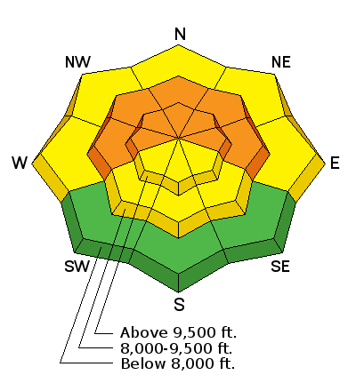
special avalanche bulletin THIS SPECIAL AVALANCHE ADVISORY IS FOR THE MOUNTAINS OF NORTHERN UTAH TO INCLUDE THE WESTERN UINTAS. DANGEROUS HUMAN TRIGGERED AVALANCHES MAY BE TRIGGERED IN STEEP WEST TO NORTH TO EAST FACING TERRAIN ABOVE 8000` IN ELEVATION. EXPERT ROUTE-FINDING IS REQUIRED FOR SAFE TRAVEL IN THE MOUNTAINS. THIS SPECIAL AVALANCHE ADVISORY WILL CONTINUE THROUGH THE WEEKEND. THIS ADVISORY DOES NOT INCLUDE SKI AREAS OR HIGHWAYS WHERE AVALANCHE CONTROL IS NORMALLY DONE. |
 |
current conditions Skies are mostly cloudy and winds are generally light from the northwest. Colder air from the northwest has filtered in, dropping temps into the single digits and teens. Spring hopes eternal are dashed and winter continues, if only through the weekend. Still, we needed this last shot of snow like a dying man needs water - we roughly sit at 70-80% of normal. By the time the last snowflake settled, most areas had picked up a cool foot of snow, with the Ogden mountains picking up a foot and a half. Provo, on the other hand, picked up 4". But the numbers are deceiving...marketing experts focus on the snow amounts while avalanche hunters focus on the water numbers (ie- 12" of snow averaging 15% affects the snowpack differently than 12" of cold smoke). In other words, despite only picking up 4", the Provo mountains raked in roughly 1.37" of precipitation...which, with colder temps could have easily translated to 18" of fluff. Which is part of the reason why Ogden and Provo had HIGH danger ratings yesterday. Initial rain/snow lines in those areas began at 7500'. Trend plays a part as well - initial densities started at 11-13%...then dropped toward 7% - what we'd call "right-side-up". An opposite density trend would be "upside-down", which is how some of us end up in the snow with the challenging turning conditions...and tends to be a bit "touchier" in the avalanche realm.
|
 |
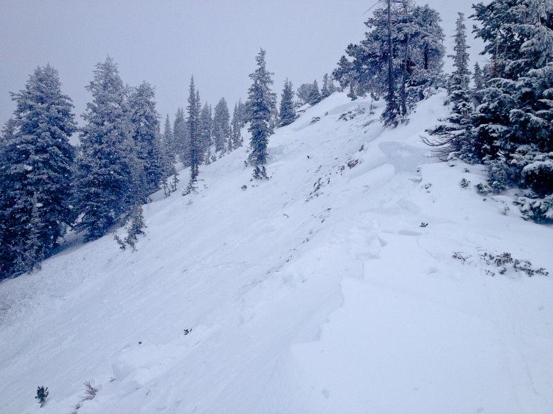
recent activity Those that earn a living doing avalanche control work reported widespread avalanche activity that responded well to both ski cuts and explosives. Some slides, as expected, stepped down into older, weaker snow...with some gouging or stepping to the ground. Not surprisingly, few got out and about yesterday. Those that did reported widespread cracking and collapsing, with one significant skier release on the north side of Davenport Hill along the Cottonwood ridgeline into Silver Fork. A very experienced skier/avalanche worker stepped down onto a measured 32 degree slope (connected to adjacent 36 degree terrain), the snow buckled, but he was able to arrest onto the bed surface. Of note, he observed that in places, the slab pulled out near the ridge on portions of ~30 degree terrain. The slab averaged 12" deep, but stepped down in places up to 2 and even 3' deep. This on a northwest facing slope at 10,000'. (photo C. Cawley, below) His excellent write-up can be found here. Again - thanks - this open/transparent info saves lives.
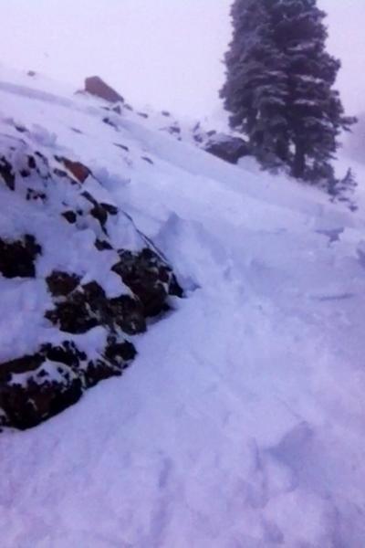
Another party touring off the Park City ridgeline in the Canyons periphery triggered a couple 2' deep and 40' wide pockets on steep northeast facing terrain at 9500'. (photo Geissler, below)
|
| type | aspect/elevation | characteristics |
|---|

|
|
LIKELIHOOD
 LIKELY
UNLIKELY
SIZE
 LARGE
SMALL
TREND
 INCREASING DANGER
SAME
DECREASING DANGER
|
|
description
The storm snow should remain quite sensitive to provocation today, particularly in areas that saw the most snow and wind. Heightened avalanche conditions will be more pronounced along the northwest to easterly facing terrain at the mid and upper elevations. Cracking and collapsing should be key indicators still of instability. These avalanches are likely to be 12-16" deep and up to 1-200' wide. As much of the storm snow fell on weak surface snow, they may also be triggered remotely, or break above you. Warning! - Any new snow slide on mid to upper elevation west through north through east facing slopes above 8000' may step down another 1-2' deep into older, weaker faceted snow from late November, making these significantly more dangerous. |
| type | aspect/elevation | characteristics |
|---|

|
|
LIKELIHOOD
LIKELY
UNLIKELY
SIZE
 LARGE
SMALL
TREND
 INCREASING DANGER
SAME
DECREASING DANGER
|
|
description
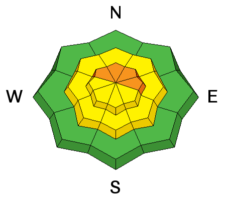
It's almost a shame. We've been nickle and dime-ing the structural weaknesses in the snowpack for the last month...with just not enough snow and wind to deliver a knock-out punch for a widespread avalanche cycle. Instead, we'll suffer the next few days with set mouse-traps here and there. Any slides triggered in the west to north to east facing slopes (which hold well preserved weak interfaces of snow) may step down 1-3' deep and propagate over longer distances. They may also be triggered remotely, or break above you. By and large, we'd tell people to avoid this terrain or - if you do head into the west-north-east facing terrain, choose gentler* slopes to recreate on. So what's "gentler"? Generally less than 35 degrees. But there's always the fine print - harder slabs of snow failing on facets or surface hoar will avalanche on steeper slopes but can propagate through the strength of the slab onto lower angle slopes. I personally have been ripped off a slope in mid-20 degree terrain. So the take-home point - ensure you're not on, below, or adjacent to slopes approaching 35 degrees and steeper. |
 |
weather We'll have mostly cloudy skies today with generally light winds from the west and northwest. Temps will be in the low to mid teens. Another storm from the northwest is rapidly approaching that'll affect the Wasatch tonight and linger through the weekend. Moderate with periods of strong northwest wind will accompany the storm tomorrow with expected snowfall in the 4-7" range. Riming is possible with this storm. Another brush-by is expected late Monday/early Tues with high pressure returning for mid-week. |
| general announcements
This information does not apply to developed ski areas or highways where avalanche control is normally done. This advisory is from the U.S.D.A. Forest Service, which is solely responsible for its content. This advisory describes general avalanche conditions and local variations always occur. If you trigger an avalanche in the backcountry - especially if you are adjacent to a ski area – please call the following teams to alert them to the slide and whether anyone is missing or not. Rescue teams can be exposed to significant hazard when responding to avalanches, and do not want to do so when unneeded. Thanks. Salt Lake and Park City – Alta Central (801-742-2033), Canyons Resort Dispatch (435-615-3322) Snowbasin Resort Dispatch (801-620-1017), Powder Mountain Dispatch (801-745-3772 x 123). Sundance Dispatch (801-231-4150) DAWN PATROL Hotline updated daily by 5-530am - 888-999-4019 option 8. Twitter Updates for your mobile phone - DETAILS UDOT canyon closures: LINK TO UDOT Utah Avalanche Center mobile app - Get your advisory on your iPhone along with great navigation and rescue tools. We'll soon be lining up a new automated emailed advisory delivery system - stay tuned. Wasatch Powderbird Guides Blog/Itinerary for the Day. They'll be up and running later this winter - Lost or Found something in the backcountry? - http://nolofo.com/ Discount lift tickets are now available at Backcountry.com - Thanks to Ski Utah and the Utah Resorts. All proceeds go towards paying for Utah Avalanche Center avalanche and mountain weather advisories. To those skinning uphill at resorts: it is your responsibility to know the resort policy on uphill travel. Some allow uphill travel and have guidelines, some don't. Contact the Ski Patrol at each resort for details. IMPORTANT: Before skinning at a resort under new snow conditions, check in with Ski Patrol. Resorts can restrict or cut off access if incompatible with control and grooming operations. Benefit the Utah Avalanche Center when you shop from Backcountry.com or REI: Click this link for Backcountry.com or this link to REI, shop, and they will donate a percent of your purchase price to the UAC. Both offer free shipping (with some conditions) so this costs you nothing! Benefit the Utah Avalanche Center when you buy or sell on ebay - set the Utah Avalanche Center as a favorite non-profit in your ebay account here and click on ebay gives when you buy or sell. You can choose to have your seller fees donated to the UAC, which doesn't cost you a penny. Remember your information can save lives. If you see anything we should know about, please participate in the creation of our own community avalanche advisory by submitting snow and avalanche conditions. You can also call us at 801-524-5304 or 800-662-4140, email by clicking HERE, or include #utavy in your tweet or Instagram. |