| During the month of April, Mark Miller will donate $75 to the charity of your choice (5 to chose from, including the Utah Avalanche Center!) Mark Miller Subaru has raised over $300k in the previous 6 Do Good Feel Good events. More Info here |  |
| During the month of April, Mark Miller will donate $75 to the charity of your choice (5 to chose from, including the Utah Avalanche Center!) Mark Miller Subaru has raised over $300k in the previous 6 Do Good Feel Good events. More Info here | |
| Advisory: Salt Lake Area Mountains | Issued by Drew Hardesty for Thursday - December 19, 2013 - 6:58am |
|---|

|
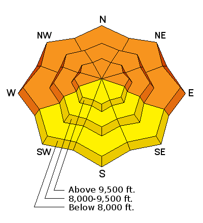
bottom line The danger is CONSIDERABLE with natural avalanches likely occurring up high this morning; human triggered slides will be likely on many slopes approaching 35 degrees and steeper. The danger may be pushing HIGH in the Provo and Ogden area mountains. Avalanches may be triggered at a distance with any slides triggered on west through north through east facing slopes having the potential to STEP DOWN 1-2' deep or more, creating larger, more dangerous avalanches. Steep lower elevation shady terrain should be avoided due to wet loose avalanche potential.
|
 |
special avalanche bulletin THIS SPECIAL AVALANCHE ADVISORY IS FOR THE MOUNTAINS OF NORTHERN UTAH. DANGEROUS AVALANCHE CONDITIONS EXIST AND ARE MORE PRONOUNCED IN THE OGDEN AND PROVO AREA MOUNTAINS AS WELL AS THE WESTERN UINTAS. NATURAL AND HUMAN TRIGGERED AVALANCHES ARE LIKELY. THIS ADVISORY DOES NOT INCLUDE SKI AREAS OR HIGHWAYS WHERE AVALANCHE CONTROL IS NORMALLY DONE. |
 |
special announcement Mountain guide and Utah Mountain Adventures owner Tyson Bradley will be speaking on Thursday, at the Wildflower at Snowbird as part of the Utah Adventure Journal Speaker Series. DETAILS |
 |
current conditions For a split storm, things are piling up pretty good. With what we call a warm air advection pattern, snowfall coming in on a southwesterly flow has been fairly fast and furious since just before midnight. Amounts as of 5am are below, though it should be noted that densities are in the 11-13% range. Southwest winds are 20-30mph with gusts near 60 along the highest ridgelines. Temps are in the upper 20s to low 30s, with a rough rain/snow line (tricky with the inversion) at 7000-7500'. Ogden mountains - 6-8" Park City area mountains 4-6" Big Cottonwood 6-8" Little Cottonwood 4-5" Provo 4-6" A note on longevity and rituals. Recently Noah Howell (Powderwhore ski-film maker and hard charging skier) posted some insightful thoughts on how we make decisions in the backcountry and what sorts of things affect our decision making. The goal is not the intended alpine objective per se, but making it back to his truck at the end of the day. Photographer Adam Clark, in an interview with Black Diamond Equipment, reflects back on his involvement in last week's Grizzly Gulch full burial and live recovery. It's more a testament to his character to be open with his thoughts and experience, which is not always the case in our community. He discusses important rituals for safety in the backcountry. While I was reading these, a Holiday card arrived from a long-time Utah Avalanche Center forecaster - now long retired. He talks about getting old, a bit slower, a bit weaker and tends to go on backcountry outings now by himself. Our hero Norman Maclean, toward the end of his life, writes, "now I am too old to be much of a fisherman, and now of course I usually fish the big waters alone, although some friends think I shouldn't. But eventually, all things merge into one, and a river runs through it." We should all be so lucky. Take the long view, friends, remember those rituals.
|
| type | aspect/elevation | characteristics |
|---|

|
|
LIKELIHOOD
 LIKELY
UNLIKELY
SIZE
 LARGE
SMALL
TREND
 INCREASING DANGER
SAME
DECREASING DANGER
|
|
description
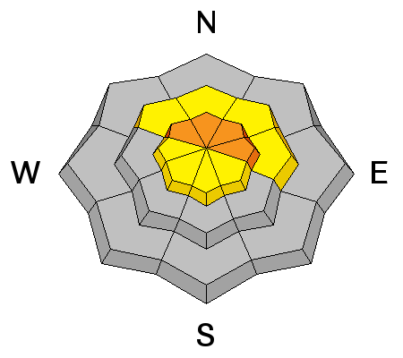
New wind drifts along the mid and upper elevation northwest through easterly facing terrain will be sensitive to human provocation today. These drifts will be 1-2' deep and may be triggered from a distance. Cracking and collapsing are immediate signs of instability. Warning! - Any new snow slide on mid to upper elevation west through north through east facing slopes above 8000' may step down another 1-2' deep into older, weaker faceted snow from late November, making these significantly more dangerous. |
| type | aspect/elevation | characteristics |
|---|

|
|
LIKELIHOOD
LIKELY
UNLIKELY
SIZE
LARGE
SMALL
TREND
INCREASING DANGER
SAME
DECREASING DANGER
|
|
description
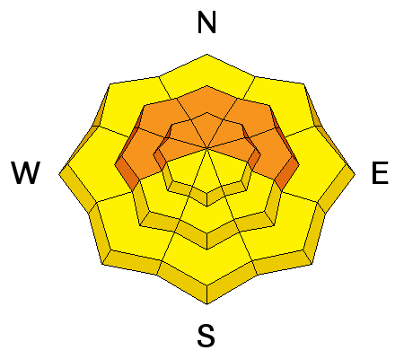
Heavy dense new snow should bond poorly to the weak snow surfaces and will likely be sensitive on slopes approaching 35 degrees and steeper. As with the wind drifts, remotely triggered slides may be possible. Test slopes will give some idea of in the instability. Cracking is a sure give-away for instability. Warning! - Any new snow slide on mid to upper elevation west through north through east facing slopes above 8000' may step down another 1-2' deep into older, weaker faceted snow from late November, making these significantly more dangerous. |
| type | aspect/elevation | characteristics |
|---|

|

|
LIKELIHOOD
LIKELY
UNLIKELY
SIZE
LARGE
SMALL
TREND
 INCREASING DANGER
SAME
DECREASING DANGER
|
|
description
Any rain on snow event in the shady sheltered west through north through easterly facing slopes will produce both natural and easy human triggered wet loose avalanches. Avoid being in or above terrain traps such as steep walled gullies or creek-beds as loose wet snow may pile up more deeply. |
 |
weather We'll see continued snowfall throughout the day, with many areas expected to receive another 4-8" of snow, particularly in the Cottonwoods>north. Winds should become more westerly and lose some steam, dropping to 15mph. Temps will slowly drop to the low 20s at 10,000' and the mid to upper 20s at 8000'. Another storm from the northwest arrives late Friday through the weekend, bringing another round of snow to the Wasatch. |
| general announcements
This information does not apply to developed ski areas or highways where avalanche control is normally done. This advisory is from the U.S.D.A. Forest Service, which is solely responsible for its content. This advisory describes general avalanche conditions and local variations always occur. If you trigger an avalanche in the backcountry - especially if you are adjacent to a ski area – please call the following teams to alert them to the slide and whether anyone is missing or not. Rescue teams can be exposed to significant hazard when responding to avalanches, and do not want to do so when unneeded. Thanks. Salt Lake and Park City – Alta Central (801-742-2033), Canyons Resort Dispatch (435-615-3322) Snowbasin Resort Dispatch (801-620-1017), Powder Mountain Dispatch (801-745-3772 x 123). Sundance Dispatch (801-231-4150) DAWN PATROL Hotline updated daily by 5-530am - 888-999-4019 option 8. Twitter Updates for your mobile phone - DETAILS UDOT canyon closures: LINK TO UDOT Utah Avalanche Center mobile app - Get your advisory on your iPhone along with great navigation and rescue tools. We'll soon be lining up a new automated emailed advisory delivery system - stay tuned. Wasatch Powderbird Guides Blog/Itinerary for the Day. They'll be up and running later this winter - Lost or Found something in the backcountry? - http://nolofo.com/ Discount lift tickets are now available at Backcountry.com - Thanks to Ski Utah and the Utah Resorts. All proceeds go towards paying for Utah Avalanche Center avalanche and mountain weather advisories. To those skinning uphill at resorts: it is your responsibility to know the resort policy on uphill travel. Some allow uphill travel and have guidelines, some don't. Contact the Ski Patrol at each resort for details. IMPORTANT: Before skinning at a resort under new snow conditions, check in with Ski Patrol. Resorts can restrict or cut off access if incompatible with control and grooming operations. Benefit the Utah Avalanche Center when you shop from Backcountry.com or REI: Click this link for Backcountry.com or this link to REI, shop, and they will donate a percent of your purchase price to the UAC. Both offer free shipping (with some conditions) so this costs you nothing! Benefit the Utah Avalanche Center when you buy or sell on ebay - set the Utah Avalanche Center as a favorite non-profit in your ebay account here and click on ebay gives when you buy or sell. You can choose to have your seller fees donated to the UAC, which doesn't cost you a penny. Remember your information can save lives. If you see anything we should know about, please participate in the creation of our own community avalanche advisory by submitting snow and avalanche conditions. You can also call us at 801-524-5304 or 800-662-4140, email by clicking HERE, or include #utavy in your tweet or Instagram. |