
| During the month of April, Mark Miller will donate $75 to the charity of your choice (5 to chose from, including the Utah Avalanche Center!) Mark Miller Subaru has raised over $300k in the previous 6 Do Good Feel Good events. More Info here |  |
| During the month of April, Mark Miller will donate $75 to the charity of your choice (5 to chose from, including the Utah Avalanche Center!) Mark Miller Subaru has raised over $300k in the previous 6 Do Good Feel Good events. More Info here | |
| Advisory: Salt Lake Area Mountains | Issued by Evelyn Lees for Saturday - December 14, 2013 - 7:04am |
|---|

|
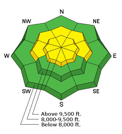
bottom line The avalanche danger Is MODERATE on west through north through easterly facing slopes, for triggering a 1 to 2 foot deep slab avalanche. The greatest danger is above about 9,000. HUMAN-TRIGGERED AVALANCHES ARE POSSIBLE. While the chance of triggering a slide is becoming less with each day, any slide you trigger will be just as dangerous - up to 150’ wide, 2’ deep, with stepped up consequences due to the potential for a long, rocky ride. Also avoid any steep slopes with new or old drifts of wind-blown snow. Continue to recreate on lower angle slopes, less steep than about 35 degrees, in wind sheltered terrain.
|
 |
current conditions Under mostly clear skies, temperatures are in the teens this morning, and the northwesterly winds are light. Most stations are averaging less than 15 mph, and even the high peaks are less than 30 mph in the Salt Lake mountains. Wind speeds are even less in the Ogden and Provo area mountains. Sunny slopes are crusted, there’re hard and breakable wind slabs up high, but the treat is mid elevation, wind and sun sheltered slopes, with soft, recrystallized powder. The snowpack is still shallow, though, and take care to avoid the rocks and stumps lurking beneath the surface. |
 |
recent activity Just a few observations from yesterday – along the Park City ridge line, explosive control work released several soft slabs that then gouged into facets near the ground and were long running. These were on NNE facing slopes, at 9,800’. A few minor soft slabs were also triggered in steep terrain. Collapsing was noted in Pole Canyon (a drainage in Mill Creek) on a NW facing slope at 8800’. |
| type | aspect/elevation | characteristics |
|---|

|
|
LIKELIHOOD
 LIKELY
UNLIKELY
SIZE
 LARGE
SMALL
TREND
 INCREASING DANGER
SAME
DECREASING DANGER
|
|
description
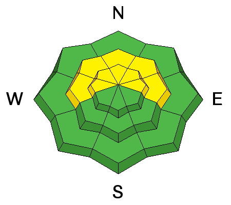
Very poor snow pack structure remains, and I find steep, northerly facing slopes down right spooky. While the chance of triggering a slide is slowly decreasing, the consequences are no less. Deep, dangerous slides can still be triggered, remotely from below or from the side. Any collapsing is a sign of a very unstable snow pack. Continue to avoid the steep, shady slopes. A triggered shallow soft slab avalanche, wind drift or sluff could step down into the deeper weak layers. |
| type | aspect/elevation | characteristics |
|---|

|
|
LIKELIHOOD
 LIKELY
UNLIKELY
SIZE
 LARGE
SMALL
TREND
 INCREASING DANGER
SAME
DECREASING DANGER
|
|
description
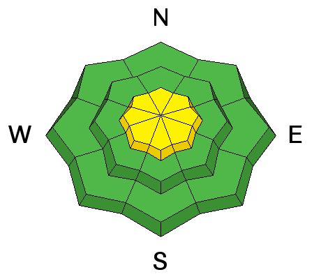
Wind slabs continue to lurk in the high elevation terrain:
|
 |
weather Head to the mountains to warm up today – highs will be near 30 at 8,000’ and 20 at 10,000’, and with partly cloudy skies in the forecast, there should even be some sunshine. The northwesterly winds will remain light today, in the 10 to 20 mph range. Across the high ridgelines and peaks, speeds could increase into the 25 to 35 mph range later today and tonight. High pressure will continue to dominate the northern Utah weather through mid-week, with sunny skies and warming temperatures in the mountains. The next chance for a storm and snow looks to be around Thursday. |
| general announcements This information does not apply to developed ski areas or highways where avalanche control is normally done. This advisory is from the U.S.D.A. Forest Service, which is solely responsible for its content. This advisory describes general avalanche conditions and local variations always occur. If you trigger an avalanche in the backcountry - especially if you are adjacent to a ski area – please call the following teams to alert them to the slide and whether anyone is missing or not. Rescue teams can be exposed to significant hazard when responding to avalanches, and do not want to do so when unneeded. Thanks. Salt Lake and Park City – Alta Central (801-742-2033), Canyons Resort Dispatch (435-615-3322) Snowbasin Resort Dispatch (801-620-1017), Powder Mountain Dispatch (801-745-3772 x 123). Sundance Dispatch (801-231-4150) Twitter Updates for your mobile phone - DETAILS UDOT canyon closures: LINK TO UDOT Utah Avalanche Center mobile app - Get your advisory on your iPhone along with great navigation and rescue tools. We'll soon be lining up a new automated emailed advisory delivery system - stay tuned. Wasatch Powderbird Guides Blog/Itinerary for the Day. They'll be up and running later this winter - Discount lift tickets are now available at Backcountry.com - Thanks to Ski Utah and the Utah Resorts. All proceeds go towards paying for Utah Avalanche Center avalanche and mountain weather advisories. To those skinning uphill at resorts: it is your responsibility to know the resort policy on uphill travel. Some allow uphill travel and have guidelines, some don't. Contact the Ski Patrol at each resort for details. IMPORTANT: Before skinning at a resort under new snow conditions, check in with Ski Patrol. Resorts can restrict or cut off access if incompatible with control and grooming operations. Benefit the Utah Avalanche Center when you shop from Backcountry.com or REI: Click this link for Backcountry.com or this link to REI, shop, and they will donate a percent of your purchase price to the UAC. Both offer free shipping (with some conditions) so this costs you nothing! Benefit the Utah Avalanche Center when you buy or sell on ebay - set the Utah Avalanche Center as a favorite non-profit in your ebay account here and click on ebay gives when you buy or sell. You can choose to have your seller fees donated to the UAC, which doesn't cost you a penny. Remember your information can save lives. If you see anything we should know about, please participate in the creation of our own community avalanche advisory by submitting snow and avalanche conditions. You can also call us at 801-524-5304 or 800-662-4140, email by clicking HERE, or include #utavy in your tweet or Instagram. |


