| During the month of April, Mark Miller will donate $75 to the charity of your choice (5 to chose from, including the Utah Avalanche Center!) Mark Miller Subaru has raised over $300k in the previous 6 Do Good Feel Good events. More Info here |  |
| During the month of April, Mark Miller will donate $75 to the charity of your choice (5 to chose from, including the Utah Avalanche Center!) Mark Miller Subaru has raised over $300k in the previous 6 Do Good Feel Good events. More Info here | |
| Advisory: Salt Lake Area Mountains | Issued by Evelyn Lees for Saturday - December 7, 2013 - 6:51am |
|---|


|
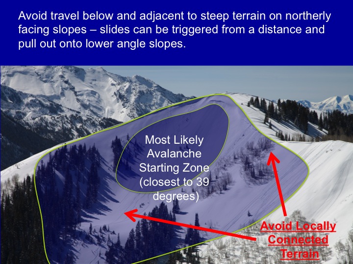
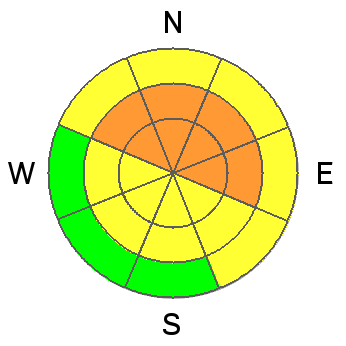
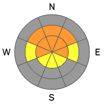
bottom line The avalanche danger is CONSIDERABLE on all wind drifted slopes, with deeper, more dangerous slides possible on northwest, north and northeasterly facing slopes at the mid and upper elevations. Slides can be triggered from below and from a distance. CONSIDERABLE means:
Head to wind sheltered and lower angle slopes today, and consider options on the southerly ½ of the compass.
|
 |
special announcement It is dangerously cold again today, with the wind chill -10 to -20 along the ridgelines. This will make it difficult to deal with even the smallest mishap – broken gear or a lost glove – much less getting caught in in avalanche, and good decision making is difficult if you get cold. |
 |
current conditions Temperatures have clawed their way out of the icebox into positive territory, and are in the single digits this morning. This has been aided by the southerly winds, averaging 15 to 20 mph, with gusts in the 30s. Wind speeds across the high ridges are unfortunately closer to 35 mph, with occasional gusts in the 40s and 50s. (Ogden area mountains gusting to 60 mph). The snowpack remains very shallow, but travel choices are expanding – smooth slopes, trails and roads at the mid elevations and on some southerly facing slopes now have just enough snow for travel. |
 |
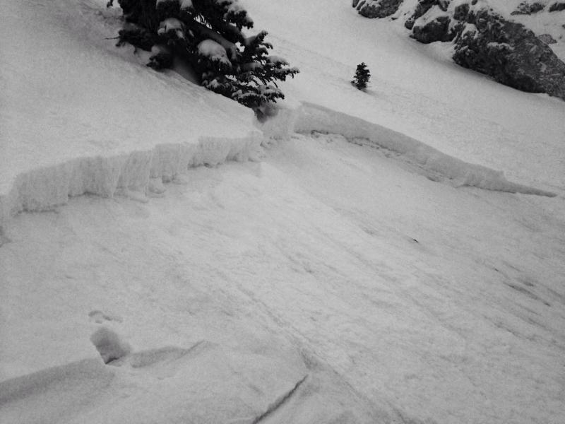
recent activity Two slides were reported yesterday – a snowboarder triggered slide off NE facing Rocky Point, about 8-18" deep by 25' wide, a repeater failing on faceted snow near the ground, and a new snow soft slab on a NW facing slope off Pioneer Ridge, that propagated to 150' wide below chute. The newly forming wind drifts were cracking by midafternoon. Todd Glew witnessed the Rocky Point slide. Full observation here.
|
| type | aspect/elevation | characteristics |
|---|

|
|
LIKELIHOOD
 LIKELY
UNLIKELY
SIZE
 LARGE
SMALL
TREND
 INCREASING DANGER
SAME
DECREASING DANGER
|
|
description
There are acre feet of snow available for transport, and the steady winds are the perfect speed to drift the snow. The drifts will be sensitive on any steep slope, failing on the cold snow weak snow beneath. While widespread along the high ridges, drifts will also be found at the mid elevations and cross loaded on to a variety of aspects. Wind drifts will be cracky, can be triggered from a distance, and a small wind slab avalanche can trigger a larger, deeper slide as it moves down slope. |
| type | aspect/elevation | characteristics |
|---|

|
|
LIKELIHOOD
 LIKELY
UNLIKELY
SIZE
 LARGE
SMALL
TREND
INCREASING DANGER
SAME
DECREASING DANGER
|
|
description
The southerly wind direction is drifting snow onto the fragile, faceted snowpack on northwest, north and northeasterly facing slopes. The winds are creating the denser, heavier slab that should finally overload the weak facets, for a more widespread avalanche cycle. I expect some natural avalanche activity today, with smaller slides having the potential to step down, triggering a deeper, wider slide. Slides can also be triggered remotely, from below, the side or above. The avalanche danger will be increasing later today through tonight if we get the snow in the forecast.
|
 |
weather It’s a tardy storm, but still on track, and light snow should start to fall by late morning. Snow intensities will pick up this afternoon, with 3 to 7 inches expected today, and another 6 to 10 inches tonight. Areas favored by southwest flow will get the higher snow numbers today. Snow will continue into Sunday, with 10 to 20” storm totals. Winds today will be moderate to strong from the southwest ahead of the frontal passage, with 20 to 30 mph averages along the high ridges, and gusts into 40s and 50s. The cold front will arrive late this afternoon, and winds will shift to the northwest and decrease. 10,000’ temperatures will warm to near 10 today, dropping back to zero tonight. |
| general announcements This information does not apply to developed ski areas or highways where avalanche control is normally done. This advisory is from the U.S.D.A. Forest Service, which is solely responsible for its content. This advisory describes general avalanche conditions and local variations always occur. If you trigger an avalanche in the backcountry - especially if you are adjacent to a ski area – please call the following teams to alert them to the slide and whether anyone is missing or not. Rescue teams can be exposed to significant hazard when responding to avalanches, and do not want to do so when unneeded. Thanks. Salt Lake and Park City – Alta Central (801-742-2033), Canyons Resort Dispatch (435-615-3322) Twitter Updates for your mobile phone - DETAILS UDOT canyon closures: LINK TO UDOT Utah Avalanche Center mobile app - Get your advisory on your iPhone along with great navigation and rescue tools. We'll soon be lining up a new automated emailed advisory delivery system - stay tuned. Wasatch Powderbird Guides Blog/Itinerary for the Day. They'll be up and running later this winter - Discount lift tickets are now available at Backcountry.com - Thanks to Ski Utah and the Utah Resorts. All proceeds go towards paying for Utah Avalanche Center avalanche and mountain weather advisories. To those skinning uphill at resorts: it is your responsibility to know the resort policy on uphill travel. Some allow uphill travel and have guidelines, some don't. Contact the Ski Patrol at each resort for details. IMPORTANT: Before skinning at a resort under new snow conditions, check in with Ski Patrol. Resorts can restrict or cut off access if incompatible with control and grooming operations. Benefit the Utah Avalanche Center when you shop from Backcountry.com or REI: Click this link for Backcountry.com or this link to REI, shop, and they will donate a percent of your purchase price to the UAC. Both offer free shipping (with some conditions) so this costs you nothing! Benefit the Utah Avalanche Center when you buy or sell on ebay - set the Utah Avalanche Center as a favorite non-profit in your ebay account here and click on ebay gives when you buy or sell. You can choose to have your seller fees donated to the UAC, which doesn't cost you a penny. Remember your information can save lives. If you see anything we should know about, please participate in the creation of our own community avalanche advisory by submitting snow and avalanche conditions. You can also call us at 801-524-5304 or 800-662-4140, email by clicking HERE, or include #utavy in your tweet or Instagram. |