| During the month of April, Mark Miller will donate $75 to the charity of your choice (5 to chose from, including the Utah Avalanche Center!) Mark Miller Subaru has raised over $300k in the previous 6 Do Good Feel Good events. More Info here |  |
| During the month of April, Mark Miller will donate $75 to the charity of your choice (5 to chose from, including the Utah Avalanche Center!) Mark Miller Subaru has raised over $300k in the previous 6 Do Good Feel Good events. More Info here | |
| Advisory: Salt Lake Area Mountains | Issued by Brett Kobernik for Wednesday - December 4, 2013 - 6:16am |
|---|


|
bottom line Overall, the avalanche danger is MODERATE. There are areas with a CONSIDERABLE danger in the upper elevation northwest through northeast facing slopes approaching 40 degrees in steepness. Human triggered avalanches are likely in these locations, natural avalanches are not expected.
|
 |
special announcement SKI AREA PREPERATION: Solitude - All of Solitude is now closed to uphill travel as they prepare to open more terrain to lift served skiing. Alta - Avoid the Supreme/Catherine's area as Alta prepares this area for lift served skiing. |
 |
current conditions Temperatures continue downward with readings
|
 |
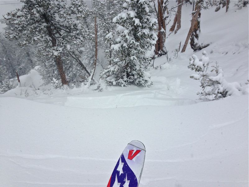
recent activity The new snow was fairly active on Tuesday with lots of cracking and a number of shallow avalanches reported also. These involved weakness within the new snow for the most part but a couple of avalanches did remove all of the new snow exposing the previous faceted snow surface.
|
| type | aspect/elevation | characteristics |
|---|

|

|
LIKELIHOOD
 LIKELY
UNLIKELY
SIZE
 LARGE
SMALL
TREND
 INCREASING DANGER
SAME
DECREASING DANGER
|
|
description
Even though the now buried faceted snow didn't seem to be all that reactive to the new load on Tuesday, I place this avalanche problem as the biggest concern today. I don't feel that the faceted snow has really showed it's cards yet. Very low density new snow and lack of wind are contributors to keeping the persistent weakness at bay. However, betting on facets to not avalanche is a loosing hand. |
| type | aspect/elevation | characteristics |
|---|

|
|
LIKELIHOOD
LIKELY
UNLIKELY
SIZE
 LARGE
SMALL
TREND
INCREASING DANGER
SAME
DECREASING DANGER
|
|
description
The new snow should be less sensitive today after a night of settlement. This avalanche problem is fairly easy to manage as it is quick to show it's cards with cracking and instant results on small steep test slopes. Poke and prod any small steep slope to get a feel if the new snow is still sensitive. |
 |
weather It'll be cold today with temperatures remaining in the single digits and light northwest winds. Expect some clouds to move in with the chance of snow flurries with no significant accumulation. Cold temperatures and chances for flurries continue Thursday and Friday with another storm moving in on Saturday which may give us some more snow accumulation. |
| general announcements
This information does not apply to developed ski areas or highways where avalanche control is normally done. This advisory is from the U.S.D.A. Forest Service, which is solely responsible for its content. This advisory describes general avalanche conditions and local variations always occur. If you trigger an avalanche in the backcountry - especially if you are adjacent to a ski area – please call the following teams to alert them to the slide and whether anyone is missing or not. Rescue teams can be exposed to significant hazard when responding to avalanches, and do not want to do so when unneeded. Thanks. Salt Lake and Park City – Alta Central (801-742-2033), Canyons Resort Dispatch (435-615-3322) Twitter Updates for your mobile phone - DETAILS UDOT canyon closures: LINK TO UDOT Utah Avalanche Center mobile app - Get your advisory on your iPhone along with great navigation and rescue tools. We'll soon be lining up a new automated emailed advisory delivery system - stay tuned. Wasatch Powderbird Guides Blog/Itinerary for the Day. They'll be up and running later this winter - Discount lift tickets are now available at Backcountry.com - Thanks to Ski Utah and the Utah Resorts. All proceeds go towards paying for Utah Avalanche Center avalanche and mountain weather advisories. To those skinning uphill at resorts: it is your responsibility to know the resort policy on uphill travel. Some allow uphill travel and have guidelines, some don't. Contact the Ski Patrol at each resort for details. IMPORTANT: Before skinning at a resort under new snow conditions, check in with Ski Patrol. Resorts can restrict or cut off access if incompatible with control and grooming operations. Benefit the Utah Avalanche Center when you shop from Backcountry.com or REI: Click this link for Backcountry.com or this link to REI, shop, and they will donate a percent of your purchase price to the UAC. Both offer free shipping (with some conditions) so this costs you nothing! Benefit the Utah Avalanche Center when you buy or sell on ebay - set the Utah Avalanche Center as a favorite non-profit in your ebay account here and click on ebay gives when you buy or sell. You can choose to have your seller fees donated to the UAC, which doesn't cost you a penny. Remember your information can save lives. If you see anything we should know about, please participate in the creation of our own community avalanche advisory by submitting snow and avalanche conditions. You can also call us at 801-524-5304 or 800-662-4140, email by clicking HERE, or include #utavy in your tweet or Instagram. |


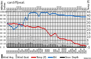 in the single digits and below zero. Winds remain light from the northwest. 5 to 9 inches of snow fell during the day on Tuesday and a few more inches of snow fell after dark bringing totals in the upper ends of the Cottonwoods to around 15 inches. (red line is temperature in the chart)