
| During the month of April, Mark Miller will donate $75 to the charity of your choice (5 to chose from, including the Utah Avalanche Center!) Mark Miller Subaru has raised over $300k in the previous 6 Do Good Feel Good events. More Info here |  |
| During the month of April, Mark Miller will donate $75 to the charity of your choice (5 to chose from, including the Utah Avalanche Center!) Mark Miller Subaru has raised over $300k in the previous 6 Do Good Feel Good events. More Info here | |
| Advisory: Salt Lake Area Mountains | Issued by Drew Hardesty for Tuesday - December 3, 2013 - 6:37am |
|---|

|
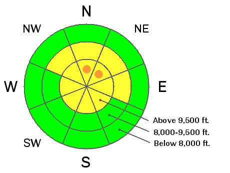
bottom line An overall MODERATE danger exists for human triggered wind drifts and storm snow avalanches. Areas of CONSIDERABLE may exist in the upper regions of Big Cottonwood and along the Park City ridgeline, areas that have seen more snow and wind over the past 24 hours. Remotely triggered slides are possible in mid to upper elevation northerly facing terrain. Caution: this forecaster's certainty level is only fair with much pre and post storm variability. I would probably choose north or east facing wind-sheltered terrain, initially avoiding slopes above about 35 degrees - with nothing steeper above.
|
 |
special announcement Those heading in to upper Little Cottonwood should avoid the Supreme/Catherine's area as Alta is conducting operations to open this terrain for the lift served skiers. Extra Caution Advised for this week! - It's been mostly LOW danger for the past week. Now with the arrival of a new storm, don't let powder fever cloud your judgement - let the avalanche conditions settle out before jumping into the steep terrain. Remember that consequences are greater with a thin snowpack as a catch and carry results in the victim getting dragged through thinly veiled stumps and rocks. Be disciplined with your good safe travel protocol - only one on the slope at a time, maintain visual contact, and have a plan - have good communication among your party and between other parties out there.
|
 |
current conditions Wildly variable snow surface conditions prior to the storm have been met with equally variable snow numbers from the storm. The west to southwesterly storm track well favored the Park City ridgeline, upper Big Cottonwood, and the backside of the Ogden area mountains (Monte Cristo and Lightning Ridge areas) with upwards of a foot of new snow. Little Cottonwood has 5" while Provo has cashed in its chips with an inch or two. Temps have dropped into the low 20s; winds are west to northwest blowing 15-20mph with gusts to 30. Precip, winds, and temps will plummet and dry out within a few hours this morning.
|
| type | aspect/elevation | characteristics |
|---|

|
|
LIKELIHOOD
 LIKELY
UNLIKELY
SIZE
 LARGE
SMALL
TREND
 INCREASING DANGER
SAME
DECREASING DANGER
|
|
description
New wind drifts up to 18" can be expected along the higher, more exposed ridgelines and it wouldn't be out of the question to see a slide or two triggered at a distance. These drifts will be more pronounced on steep north through east through southeast facing slopes and generally confined to the upper elevations. Look for rounded pillows and jump on test slopes and choose more conservative terrain at the outset before moving into more open, steeper slopes. |
| type | aspect/elevation | characteristics |
|---|

|

|
LIKELIHOOD
LIKELY
UNLIKELY
SIZE
LARGE
SMALL
TREND
 INCREASING DANGER
SAME
DECREASING DANGER
|
|
description
The new snow should bond poorly to the slick wind crusts and areas of weak, loose pre-existing snow, particularly in the northerly terrain. "It feels slabby', commented a couple avalanche workers this morning, before they headed out the door. So let's keep it simple - it's guilty until proven otherwise. |
 |
weather We should see another few inches of snow on a west to northwest flow this morning with winds veering to the north and dropping to 10-15mph on all but the highest most exposed anemometers. Mountain temps will plummet to the single digits by tonight and zero by tomorrow morning. We'll be 4 below by Thursday at 9-10,000'. We may see a couple inches here and there over the next couple days with the next storm on track for the weekend. |
general announcements
If you trigger an avalanche in the backcountry - especially if you are adjacent to a ski area – please call the following teams to alert them to the slide and whether anyone is missing or not. Rescue teams can be exposed to significant hazard when responding to avalanches, and do not want to do so when unneeded. Thanks. Salt Lake and Park City – Alta Central (801-742-2033), Canyons Resort Dispatch (435-615-3322) Twitter Updates for your mobile phone - DETAILS UDOT canyon closures: LINK TO UDOT Utah Avalanche Center mobile app - Get your advisory on your iPhone along with great navigation and rescue tools. We'll soon be lining up a new automated emailed advisory delivery system - stay tuned. Wasatch Powderbird Guides Blog/Itinerary for the Day. They'll be up and running later this winter - Discount lift tickets are now available at Backcountry.com - Thanks to Ski Utah and the Utah Resorts. All proceeds go towards paying for Utah Avalanche Center avalanche and mountain weather advisories. To those skinning uphill at resorts: it is your responsibility to know the resort policy on uphill travel. Some allow uphill travel and have guidelines, some don't. Contact the Ski Patrol at each resort for details. IMPORTANT: Before skinning at a resort under new snow conditions, check in with Ski Patrol. Resorts can restrict or cut off access if incompatible with control and grooming operations. Benefit the Utah Avalanche Center when you shop from Backcountry.com or REI: Click this link for Backcountry.com or this link to REI, shop, and they will donate a percent of your purchase price to the UAC. Both offer free shipping (with some conditions) so this costs you nothing! Benefit the Utah Avalanche Center when you buy or sell on ebay - set the Utah Avalanche Center as a favorite non-profit in your ebay account here and click on ebay gives when you buy or sell. You can choose to have your seller fees donated to the UAC, which doesn't cost you a penny. Remember your information can save lives. If you see anything we should know about, please participate in the creation of our own community avalanche advisory by submitting snow and avalanche conditions. You can also call us at 801-524-5304 or 800-662-4140, email by clicking HERE, or include #utavy in your tweet or Instagram.
|


