
| During the month of April, Mark Miller will donate $75 to the charity of your choice (5 to chose from, including the Utah Avalanche Center!) Mark Miller Subaru has raised over $300k in the previous 6 Do Good Feel Good events. More Info here |  |
| During the month of April, Mark Miller will donate $75 to the charity of your choice (5 to chose from, including the Utah Avalanche Center!) Mark Miller Subaru has raised over $300k in the previous 6 Do Good Feel Good events. More Info here | |
| Advisory: Salt Lake Area Mountains | Issued by Drew Hardesty for Sunday - November 17, 2013 - 6:06am |
|---|


|
bottom line We have a CONSIDERABLE DANGER for human triggered avalanches on steep northerly through easterly facing slopes above about 9300'. Avalanches may be triggered from a distance as well, breaking out 2-4' deep and a couple hundred feet wide. Collapsing and cracking are good clues to the instability. Best to stick to slopes less than 35 degrees in steepness and not connected to steeper terrain above. Warning! Today has all the ingredients for an avalanche accident today - a good storm, unstable snowpack, powder hungry people. Remember that consequences will be more severe with a shallow snowpack as a victim gets dragged through thinly buried rocks and stumps.
|
 |
special announcement Both Snowbird and Alta are closed to uphill traffic as they prepare to open. The road up Grizzly Gulch and the summer road to Catherine's Pass are open. Strong work to Alta Ski Patrol who were able to evacuate at least a couple injured skiers out of the Albion/Catherine's area. Remember it's still early season out there. |
 |
current conditions A powerful Pacific storm shook the Wasatch yesterday, with most areas picking up significant snowfall. A look at the numbers -
Snow densities averaged a 6% and while good enough for face shots and over-the-head conditions, I'd just as well ask for snow with a little more meat on it to cover up the thinly veiled rocks and other obstacles. The winds were not kind to the mountains (see Michael Janulaitis's video)...they averaged 30-40mph out of the west and southwest where even more sheltered locations felt the brunt of the wind. Temps are in the high teens to mid-20s. |
 |
recent activity Another forecaster - Brett Kobernik - and I got a late start yesterday with the hopes that enough snow/wind would both allow for easier access to the high country as well as provide enough of a load to safely trigger avalanches into the old pre-existing snow from Oct/Nov. In the end, we were still too early, as avalanches ran only within the storm snow perhaps 6-8" deep and 40' wide. Though small, they offered decent powder clouds and debris piles. I suspect, however, that enough snow/wind continued overnight that we will see evidence of natural avalanches today. More are likely to be triggered today. |
| type | aspect/elevation | characteristics |
|---|

|
|
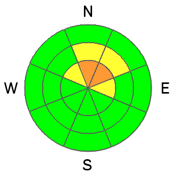
LIKELIHOOD
 LIKELY
UNLIKELY
SIZE
 LARGE
SMALL
TREND
 INCREASING DANGER
SAME
DECREASING DANGER
|
|
description
It has all the ingredients now - slab (12-18" new snow plus wind), weak layer (old snow from early Nov/mid-October), just looking for a few hungry wolves looking to jump in. The What - these persistent slabs can be 2-4' deep and perhaps 200' wide The Where - generally northwest through northeast above about 9300' The How - either by a person on or adjacent to the slope. These persistent slabs will also be triggered remotely - that is, from above, below, or adjacent to the slope. The When - all day today and at least through mid-week. Best travel would be to choose slopes less steep than 35 degrees with nothing steeper above.
|
| type | aspect/elevation | characteristics |
|---|

|
|
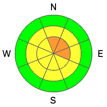
LIKELIHOOD
LIKELY
UNLIKELY
SIZE
 LARGE
SMALL
TREND
 INCREASING DANGER
SAME
DECREASING DANGER
|
|
description
The stronger winds will likely create larger, more stubborn wind drifts both along - and off - the high ridgelines. These wind slabs may be triggered both at your feet, but may also pull out above you. They're more pronounced on north through east through southerly facing aspects, but may be found in many unusual places today. |
 |
weather We'll see mostly cloudy turning to partly cloudy skies today as the last few snowflakes fade away. Winds will be 20-25mph along the rigelines from the west, diminishing as they back to the southwest. Temps will continue to rise to low 20s today, the upper 20s tonight. A disturbance affects the region mid-week with a cut-off Low diving south by Friday into the weekend. |
| general announcements If you trigger an avalanche in the backcountry - especially if you are adjacent to a ski area – please call the following teams to alert them to the slide and whether anyone is missing or not. Rescue teams can be exposed to significant hazard when responding to avalanches, and do not want to do so when unneeded. Thanks. Salt Lake and Park City – Alta Central (801-742-2033), Canyons Resort Dispatch (435-615-3322) Twitter Updates for your mobile phone - DETAILS UDOT canyon closures UDOT at (801) 975-4838 Remember your information can save lives. If you see anything we should know about, please participate in the creation of our own community avalanche advisory by submitting snow and avalanche conditions. You can also call us at 801-524-5304 or 800-662-4140, email by clicking HERE, or include #utavy in your tweet or Instagram. |


