
| During the month of April, Mark Miller will donate $75 to the charity of your choice (5 to chose from, including the Utah Avalanche Center!) Mark Miller Subaru has raised over $300k in the previous 6 Do Good Feel Good events. More Info here |  |
| During the month of April, Mark Miller will donate $75 to the charity of your choice (5 to chose from, including the Utah Avalanche Center!) Mark Miller Subaru has raised over $300k in the previous 6 Do Good Feel Good events. More Info here | |
| Advisory: Salt Lake Area Mountains | Issued by Evelyn Lees for Saturday - November 16, 2013 - 5:23am |
|---|

|
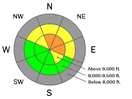
bottom line INCREASING AVALANCHE DANGER TODAY AND TONIGHT. The avalanche danger will rise from LOW to CONSIDERABLE by this afternoon or tonight as strong winds blow the new snow into sensitive drifts. The greatest danger is on the high elevation, shady slopes that held old snow before this weekend. AVOID travel on and below steep, north and northeast facing slopes above about 9,500 feet, where the new snow and drifts are underlain by weak, loose old snow. Also avoid any steep slope with fresh drifts of wind blown snow. It's a very shallow snow pack - watch out for rocks and stumps.
|
 |
special announcement Both Snowbird and Alta are closed to uphill traffic as they prepare to open. The road up Grizzly Gulch and the summer road to Catherine's Pass are open. We will update this forecast by 7:30 am Sunday morning. |
 |
current conditions Yesterday's little impulse dropped 1 to 3" of snow before clearing out. This morning, a better looking storm has just entered northern Utah and will drop south though out the morning. The southwesterly winds are increasing, into the 15 to 25 mph range, with a few peaks gusting to 30. Temperatures are in the upper teens and low twenties. Much yesterday's snow fell on bare ground - the only "base" is on upper elevation, northerly facing slopes - 12 to 18" inches in the Cottonwoods and high elevations of the Provo mountains, less than a foot on the Park City ridge line, and about 6" in the Ogden area mountains. |
 |
recent activity No new reports of avalanche activity. |
| type | aspect/elevation | characteristics |
|---|

|
|
LIKELIHOOD
 LIKELY
UNLIKELY
SIZE
 LARGE
SMALL
TREND
 INCREASING DANGER
SAME
DECREASING DANGER
|
|
description
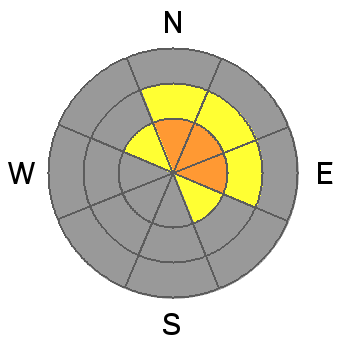
Increasingly strong winds with up to a foot of snow to blow around will create sensitive slabs by this afternoon and through the night. The weak layer will be the loose facets that were on the snow surface yesterday morning, already buried beneath yesterday's few inches. With facets as a weak layer, slides can be triggered from a distance, and from below, so be aware of your position. There was enough old snow coverage on some smooth terrain, that slides will be able to propagate across slopes, perhaps 100' or more wide, near the end of the storm. |
| type | aspect/elevation | characteristics |
|---|

|
|
LIKELIHOOD
 LIKELY
UNLIKELY
SIZE
LARGE
SMALL
TREND
INCREASING DANGER
SAME
DECREASING DANGER
|
|
description
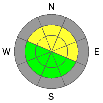
The weekend's new snow has landed on loose weak facets on mid and upper elevation northerly facing slopes and on slick crusts on the easterly facing slopes. Even in wind sheltered terrain, if you are in an area that that accumulates close to a foot or more of new snow, it will be possible to trigger a slide on a steep slope. Again, with facets as a weak layer, slides can be triggered from a distance. |
 |
weather A burley little storm is marching south, and moderate snowfall should begin in the mountains between 8 and 10 am this morning. 4 to 8" of snow is possible today, with another 3 to 6" of snow tonight. The winds throughout the storm will be mostly from a westerly direction, so snowfall amounts should be fairly even through out the range. Unfortunately, the westerly winds will ramp up throughout the day, reaching 25 mph averages at the mid elevations, and 30 to 45 mph averages along the high ridges, with gusts in the 50s. Speeds could be even stronger overnight. Temperatures will remain in the upper teens to low 20s today, before dropping into the mid to low teens tonight. The snow will end by Sunday afternoon, bringing a break through Tuesday, with another storm possible around midweek. |
| general announcements If you trigger an avalanche in the backcountry - especially if you are adjacent to a ski area – please call the following teams to alert them to the slide and whether anyone is missing or not. Rescue teams can be exposed to significant hazard when responding to avalanches, and do not want to do so when unneeded. Thanks. Salt Lake and Park City – Alta Central (801-742-2033), Canyons Resort Dispatch (435-615-3322) Twitter Updates for your mobile phone - DETAILS UDOT canyon closures UDOT at (801) 975-4838 Remember your information can save lives. If you see anything we should know about, please participate in the creation of our own community avalanche advisory by submitting snow and avalanche conditions. You can also call us at 801-524-5304 or 800-662-4140, email by clicking HERE, or include #utavy in your tweet or Instagram. |


