
| During the month of April, Mark Miller will donate $75 to the charity of your choice (5 to chose from, including the Utah Avalanche Center!) Mark Miller Subaru has raised over $300k in the previous 6 Do Good Feel Good events. More Info here |  |
| During the month of April, Mark Miller will donate $75 to the charity of your choice (5 to chose from, including the Utah Avalanche Center!) Mark Miller Subaru has raised over $300k in the previous 6 Do Good Feel Good events. More Info here | |
| Advisory: Salt Lake Area Mountains | Issued by Evelyn Lees for Friday - November 15, 2013 - 5:12am |
|---|

|
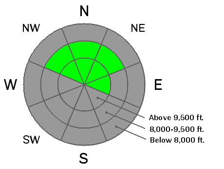
bottom line The avalanche danger is LOW this morning, but will start to increase on steep, northerly facing slopes above about 9,500'. As the new snow accumulates, it will be possible to trigger small sluffs in steep terrain. Especially avoid any steep wind drifted slopes, where it may become possible to trigger a small slab avalanche. With more snow and wind, the avalanche danger will increase significantly Saturday. I will update this forecast by 7:30 am Saturday morning. Remember, there is barely enough snow on the ground to get around on the northerly facing slopes, and hitting a rock or tree stump is likely on all but the smoothest slopes.
|
 |
special announcement
Snowbird is closed to uphill traffic starting today, Friday. We will up date this forecast by 7:30 am Saturday and Sunday mornings. Events: Bruce will give an Avalanche Awareness talk at the Museum of Natural History at 2 pm today, and there is a 7 pm fundraiser with Surface skis at Momentum Climbing gym, with a Know Before You Go talk followed by a 50% off Surface ski and apparel sale, with proceeds going to the UAC. |
 |
current conditions Light snow is falling in the mountains, as the first of two small back to back storms moves across northern Utah. Temperatures are in the twenties, and the southwesterly winds are averaging 10 to 15 mph, with gusts into the 30s along the highest ridge lines. Today's snow will fall on mostly bare ground on southeast through south through westerly facing slopes, while upper elevation northerly facing slopes hold 12 to 18" of snow in the Cottonwoods, with less than a foot along the PC ridge line, and less than 6" Ogden area mountains. The Provo area mountains are also mostly bare ground at the mid and lower elevations, but the upper elevation northerly facing slopes look to hold about the same 12 to 18" as the Cottonwoods. |
 |
recent activity Sometime in the last few days, a heavily wind drifted, high elevation northerly facing slope slid, about 4 feet deep and 50 feet wide, off the American Fork Twin on the Little Cottonwood side. Other than that, no avalanche activity has been reported for the past week. |
| type | aspect/elevation | characteristics |
|---|

|
|
LIKELIHOOD
 LIKELY
UNLIKELY
SIZE
 LARGE
SMALL
TREND
 INCREASING DANGER
SAME
DECREASING DANGER
|
|
description
The upper elevation, northerly facing slopes are the only slopes with possibly enough "base" to allow turning and riding. And today's new snow will not bond well to the old snow surface consisting of weak, loose facets. Even with only a few inches of new snow, expect to be able to trigger small, shallow sluffs in very steep terrain. If you're in an area that receives about 6 or more inches of new snow or is wind drifted, it may possible to trigger small slab avalanches, again failing on the faceted old snow surface. These could be surprisingly sensitive, and even triggered from a distance. Check out yesterday's pre-storm snow pack observations HERE. |
 |
weather The first small storm is stretched across far northern Utah, and is slowly moving south. Light snowfall today should drop 2 to 4 inches of snow in the mountains. The winds will generally remain westerly, in the 10 to 20 mph range, with only a short period of northwest flow. Gusts could briefly reach 40 mph this morning across the highest peaks. 10,000' temperatures will be in the mid 20s. There will be a brief break this afternoon and tonight, before the next storm arrives Saturday morning. This storm has the potential to bring another 6 to 10 inches of snow, mostly falling during the day Saturday, with colder temperatures and significantly stronger west to northwesterly winds. High pressure will return for Sunday through Tuesday, with another small storm possible midweek. |
| general announcements If you trigger an avalanche in the backcountry - especially if you are adjacent to a ski area – please call the following teams to alert them to the slide and whether anyone is missing or not. Rescue teams can be exposed to significant hazard when responding to avalanches, and do not want to do so when unneeded. Thanks. Salt Lake and Park City – Alta Central (801-742-2033), Canyons Resort Dispatch (435-615-3322) Twitter Updates for your mobile phone - DETAILS UDOT canyon closures UDOT at (801) 975-4838 Remember your information can save lives. If you see anything we should know about, please participate in the creation of our own community avalanche advisory by submitting snow and avalanche conditions. You can also call us at 801-524-5304 or 800-662-4140, email by clicking HERE, or include #utavy in your tweet or Instagram. |


