
| During the month of April, Mark Miller will donate $75 to the charity of your choice (5 to chose from, including the Utah Avalanche Center!) Mark Miller Subaru has raised over $300k in the previous 6 Do Good Feel Good events. More Info here |  |
| During the month of April, Mark Miller will donate $75 to the charity of your choice (5 to chose from, including the Utah Avalanche Center!) Mark Miller Subaru has raised over $300k in the previous 6 Do Good Feel Good events. More Info here | |
| Advisory: Salt Lake Area Mountains | Issued by Evelyn Lees for Sunday - November 10, 2013 - 7:36am |
|---|

|
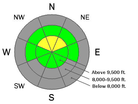
bottom line The avalanche danger remains MODERATE on steep northerly facing slopes above about 9500 feet, where a slide one to two feet deep could be triggered in isolated places. Especially avoid northerly facing slopes with recent deposits of wind drifted snow. Also, remember that rocks and stumps lurking under the thin snow cover can easily end your season with broken bones or worse. We will update this forecast mid week or as conditions change.
|
 |
special announcement Legendary big mountain skier and mountain guide Dean Cummings travels from Valdez, Alaska, to Momentum Adventure Center at Momentum Climbing Gym, Sandy, UT, to present his award-winning Steep Life Protocols and show his new film “Chugach”. The show is free but all proceeds and donations collected go to the Utah Avalanche Center! Learn, stay safe, donate, feel good! Solitude and Brighton have some runs open. All other resorts are still closed and not doing any avalanche mitigation, so you need to treat them as backcountry terrain. Be courteous, and stay out of the way of the workers and machinery. Snowbird is open again for uphill travel. |
 |
current conditions The fast start to winter has fizzled, and the best game in town may be the few runs at the two open resorts or a few, upper elevation very northerly facing slopes with smooth ground cover beneath. And what snow is left is highly variable, including crusts, with more and more rocks and stumps emerging. There is not much coverage for snowmobilers. |
 |
recent activity The last reported avalanche was 4 days ago, after a minor wind event. It was a fairly large, remotely triggered slide failing on the weak facets near the ground. Check out the avalanche list HERE. |
| type | aspect/elevation | characteristics |
|---|

|

|
LIKELIHOOD
 LIKELY
UNLIKELY
SIZE
 LARGE
SMALL
TREND
 INCREASING DANGER
SAME
DECREASING DANGER
|
|
description
The snow near the ground remains faceted and weak, and there are a few isolated places where a person could still trigger a slide - deeper and/or wind loaded slopes on very steep, northerly facing slopes. The thin snowpack is very variable, making it possible to accidentally stumble into one of these pockets. Mostly though, these weak facets are waiting for the next loading event to be reactivated, either from wind or snow, neither of which looks eminent. |
 |
weather High pressure will strengthen across Utah, with mostly clear skies, above average temperatures and light winds. 10,000' highs will be in the mid 40s with lows in the upper 20s to low 30s through Tuesday. The southwesterly winds will be generally light, with averages less than 20 mph, even across the high peaks. A flattening of the ridge mid week will cool temperatures, but hopes for snow look slim at the moment for the next week. |
| general announcements If you trigger an avalanche in the backcountry - especially if you are adjacent to a ski area – please call the following teams to alert them to the slide and whether anyone is missing or not. Rescue teams can be exposed to significant hazard when responding to avalanches, and do not want to do so when unneeded. Thanks. Salt Lake and Park City – Alta Central (801-742-2033), Canyons Resort Dispatch (435-615-3322) Twitter Updates for your mobile phone - DETAILS UDOT canyon closures UDOT at (801) 975-4838 Remember your information can save lives. If you see anything we should know about, please participate in the creation of our own community avalanche advisory by submitting snow and avalanche conditions. You can also call us at 801-524-5304 or 800-662-4140, email by clicking HERE, or include #utavy in your tweet or Instagram. |


