
| During the month of April, Mark Miller will donate $75 to the charity of your choice (5 to chose from, including the Utah Avalanche Center!) Mark Miller Subaru has raised over $300k in the previous 6 Do Good Feel Good events. More Info here |  |
| During the month of April, Mark Miller will donate $75 to the charity of your choice (5 to chose from, including the Utah Avalanche Center!) Mark Miller Subaru has raised over $300k in the previous 6 Do Good Feel Good events. More Info here | |
| Advisory: Salt Lake Area Mountains | Issued by Bruce Tremper for Friday - November 8, 2013 - 12:12pm |
|---|

|
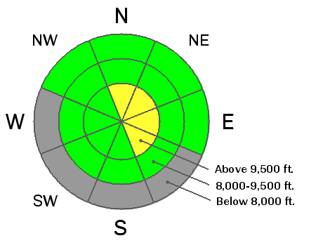
bottom line The avalanche danger remains MODERATE in steep north facing slopes above about 9500 feet especially on slopes with recent deposits of wind drifted snow. Also, remember that rocks and stumps lurking under the thin snow cover can easily end your season with broken bones or worse.
|
 |
special announcement Excuse our dust. Notice that we reverted to the advisory format from a couple years ago while we are still trying to work the bugs out of an updated design for this season. Solitude and Brighton have some runs open. All other resorts are still closed and not doing any avalanche mitigation, so you should treat all closed resorts as backcountry terrain and practice your usual avalanche skills. Snowbird is open again for uphill travel. |
 |
current conditions Yesterday was quite warm and in the afternoon, light rain fell up to 9,500' for a brief time. Most of the snow below 9,500' is damp and there is about 2 feet of dry, settled powder on the north and northeast facing slopes above about 9,500'. There is very little snow on the south facing slopes. Most of the snowmobiling areas don't have enough snow yet for access. |
 |
recent activity We have not heard about any avalanche activity for the last couple days. On Wednesday, a skier-triggered a large avalnche from a distance on Mt Baldy in Little Cottonwood Canyon. (DETAILS) It was the result of the northwest and west winds loading loose snow onto a slope that had buried weak faceted snow near the ground. It was most likely triggered from a distance by a group of skiers ascending an adjacent ridgeline. The avalanche was 2 to 4 feet deep, 200 feet wide, and ran about 900 vertical feet. This is the largest avalanche that we've seen so far this year and demonstrates that the weak faceted snow near the ground can still produce avalanches given the right criteria. There was a similar explosives-controlled slide at upper elevation, north facing slope at Snowbird on Wednesday.
|
| type | aspect/elevation | characteristics |
|---|

|
|
LIKELIHOOD
 LIKELY
UNLIKELY
SIZE
 LARGE
SMALL
TREND
 INCREASING DANGER
SAME
DECREASING DANGER
|
|
description
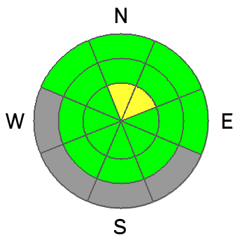
Persistent slabs still exist mostly above about 9,500' on north and northeast facing slopes. The snow from mid October has rotted away near the ground into weak, surgery depth hoar and the new snow from late October laid a slab on top of it. My snowpit tests from yesterday showed that it can still propagate on some areas but the buried weak layer is quite inconsistent and varies a lot from place to place. Also, it has been about a week since our last significant snow so the avalanche activity on this layer seems dormant right now, but I'm sure there are places where you could still trigger a potentially dangerous avalanche if you find the right spot. That said, a number of the more moderate northerly-facing slopes at upper elevations have been tracked up without incident even though you can easily feel the culprit weak layer a foot deep in the snowpack. Finally remember that with our thin snowpack any avalanche you trigger will almost certainly involve a rough ride through rocks. |
| type | aspect/elevation | characteristics |
|---|

|

|
LIKELIHOOD
LIKELY
UNLIKELY
SIZE
 LARGE
SMALL
TREND
 INCREASING DANGER
SAME
DECREASING DANGER
|
|
description
You may find small pockets of freshly wind loaded snow that may crack out on their own without a faceted weak layer. These should be very easy to manage for those with some experience in winter backcountry travel. As always, avoid steep slopes with recent wind deposits, which will look smooth and rounded. |
 |
weather At least our staff here at the Utah Avalanche Center appreciates the benign weather this past week since we have so much early season setup work to do. And it looks like the streak will continue for another week or more. It should remain warm in the mountains with daytime highs in the mid 40's and the overnight lows near freezing. Ridge top winds will blow from the west and southwest 10-15 mph. Skies should be partly cloudy to clear. The extended forecast is more of the same. |
| general announcements If you trigger an avalanche in the backcountry - especially if you are adjacent to a ski area – please call the following teams to alert them to the slide and whether anyone is missing or not. Rescue teams can be exposed to significant hazard when responding to avalanches, and do not want to do so when unneeded. Thanks. Salt Lake and Park City – Alta Central (801-742-2033), Canyons Resort Dispatch (435-615-3322) Twitter Updates for your mobile phone - DETAILS UDOT canyon closures UDOT at (801) 975-4838 Remember your information can save lives. If you see anything we should know about, please participate in the creation of our own community avalanche advisory by submitting snow and avalanche conditions. You can also call us at 801-524-5304 or 800-662-4140, email by clicking HERE, or include #utavy in your tweet or Instagram. |


