| During the month of April, Mark Miller will donate $75 to the charity of your choice (5 to chose from, including the Utah Avalanche Center!) Mark Miller Subaru has raised over $300k in the previous 6 Do Good Feel Good events. More Info here |  |
| During the month of April, Mark Miller will donate $75 to the charity of your choice (5 to chose from, including the Utah Avalanche Center!) Mark Miller Subaru has raised over $300k in the previous 6 Do Good Feel Good events. More Info here | |
| Advisory: Salt Lake Area Mountains | Issued by Brett Kobernik for Thursday - November 7, 2013 - 5:56am |
|---|

|
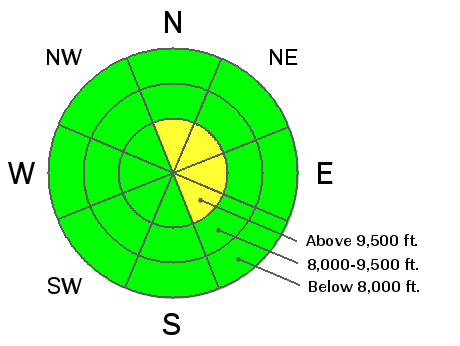
bottom line The avalanche danger remains MODERATE in steep north facing slopes above about 9500 feet with recent deposits of wind drifted snow. Rocks and stumps lurking under the thin snow cover probably present more danger to backcountry travelers right now rather than avalanches.
|
 |
special announcement As of November 5, 2013, uphill travel at Snowbird is now closed for ongoing snowmaking, avalanche control and snow cat grooming. |
 |
current conditions Temperatures have been slowly climbing over the last 48 hours and most mid elevation stations are in the mid to upper 20s. There was a minor wind event that occurred mid day yesterday with west northwest winds gusting in the 30s and 40s which doesn't sound like much but it was just enough to transport the loose snow that was on the surface. Winds have slowed again and are from the southwest. |
 |
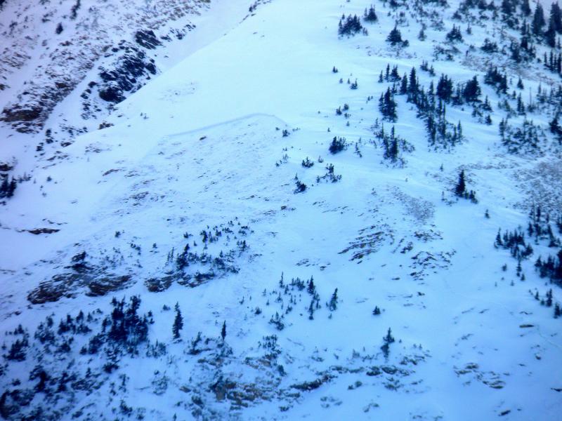
recent activity There was a significant avalanche that occurred on Wednesday on Mt Baldy in Little Cottonwood Canyon. (DETAILS) It was the result of the northwest and west winds loading loose snow onto a slope that had buried weak faceted snow near the ground. It was most likely triggered from a distance by a group of skiers ascending an adjacent ridgeline. The avalanche was 2 to 4 feet deep, 200 feet wide, and ran about 900 vertical feet. This is the largest avalanche that we've seen so far this year and demonstrates that the weak faceted snow near the ground can still produce avalanches given the right criteria.
|
| type | aspect/elevation | characteristics | ||
|---|---|---|---|---|

|

|
LIKELIHOOD
 LIKELY
UNLIKELY
SIZE
 LARGE
SMALL
TREND
 INCREASING DANGER
SAME
DECREASING DANGER
|
||
|
description
The criteria needed is a number of things that actually makes the probability fairly low of triggering one of these avalanches that breaks into the faceted persistent weak layer.
If you consider that you need ALL of these factors AND consider that the low amount of snow limits our ability to get into a lot of high elevation terrain, there are not that many places where you could trigger an avalanche. On the other hand, since the faceted weak snow is prevalent in terrain that contains the most snow, it is natural that we would want to recreate in this terrain since it does hold the most snow. A conundrum that you should take seriously. Here are a couple of recent observations:
|
| type | aspect/elevation | characteristics |
|---|

|
|
LIKELIHOOD
LIKELY
UNLIKELY
SIZE
 LARGE
SMALL
TREND
 INCREASING DANGER
SAME
DECREASING DANGER
|
|
description
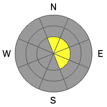
You may find small pockets of freshly wind loaded snow that may crack out on their own without a faceted weak layer. These should be very easy to manage for those with some experience in winter backcountry travel. |
 |
weather For today we'll see warmer temperatures and gradually increasing southerly winds ahead of a cold front that looks like won't produce any snow. It'll be cooler on Friday and the winds should lay down again as a ridge of high pressure builds in with mild weather. Long term, the GFS weather model advertises a system that may move through our area along about Wednesday of next week. Unfortunately, it looks like another good sized ridge moves back in directly after. This is not ideal for the snow that's on the ground as it will most likely deteriorate into faceted weak snow if we do have a long stretch with no significant storms. |
| general announcements If you trigger an avalanche in the backcountry - especially if you are adjacent to a ski area – please call the following teams to alert them to the slide and whether anyone is missing or not. Rescue teams can be exposed to significant hazard when responding to avalanches, and do not want to do so when unneeded. Thanks. Salt Lake and Park City – Alta Central (801-742-2033), Canyons Resort Dispatch (435-615-3322) Twitter Updates for your mobile phone - DETAILS UDOT canyon closures UDOT at (801) 975-4838 Remember your information can save lives. If you see anything we should know about, please participate in the creation of our own community avalanche advisory by submitting snow and avalanche conditions. You can also call us at 801-524-5304 or 800-662-4140, email by clicking HERE, or include #utavy in your tweet. |