| During the month of April, Mark Miller will donate $75 to the charity of your choice (5 to chose from, including the Utah Avalanche Center!) Mark Miller Subaru has raised over $300k in the previous 6 Do Good Feel Good events. More Info here |  |
| During the month of April, Mark Miller will donate $75 to the charity of your choice (5 to chose from, including the Utah Avalanche Center!) Mark Miller Subaru has raised over $300k in the previous 6 Do Good Feel Good events. More Info here | |
| Advisory: Salt Lake Area Mountains | Issued by Drew Hardesty for Monday - November 4, 2013 - 8:05pm |
|---|

|
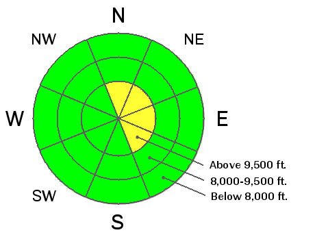
bottom line Isolated pockets of MODERATE exist for triggering shallow slab avalanches 1-1.5 feet deep and 50' wide. The pockety hazard is generally confined to steep north to northeast facing wind drifted terrain (just off the ridgelines) above roughly 9500'. Shallow new storm snow avalanches may also be triggered by a person in the steepest terrain above 9000'. Remember that consequences can be more severe in the early season as avalanche victims tend to get raked through the thinly buried rocks, stumps, and deadfall. There have already been 2 close calls in the Colorado mountains on a similar snowpack with another reported catch and carry in northern Wyoming near Togwotee Pass.
|
 |
special announcement Thank you to everyone who attended this year's Utah Snow and Avalanche Workshop and thank you to our primary sponsor for the event, Xinsurance. Every year it's confirmed that we have the greatest backcountry community to go with the Greatest Snow on Earth. As resorts ready to open, please be courteous, obey any signage, and watch for workers and machines. Remember, the mountain resorts have not conducted any avalanche control work and their terrain MUST be treated as the backcountry. Update - Snowbird is now closed to uphill traffic as they are getting ready for the season and starting their avalanche reduction. WE WILL UPDATE THIS FORECAST AS CONDITIONS WARRANT - |
 |
current conditions We squeezed another 2-3" today out of the moist northwest flow yesterday with another 2-4" of cold smoke overnight. It certainly feels like winter, with temps in the low teens to single digits. Winds, mercifully, remained generally low key but have become gusty this morning with ridgetop winds in the 20s and a few gusts into the 40s. Average snow depths in the upper elevation northerly facing Cottonwoods range from 1-2' with a touch more in the steep wind drifted easterly facing terrain along the high ridgelines. In the outlying areas and on the southerly and off (east and west) aspects, there's just enough to hide the ground cover. Forecaster Brett Kobernik put this great early season snow/weather video segment together - it's worth checking out.
|
 |
recent activity Last Tuesday/Wednesday's avalanches and sensitivity seem like a thing of the past; yet the poor conditionally unstable structure lingers on. Time and settlement have conspired to turn certainty towards something, well, less so. Now, nearly a week later, cracking and collapsing, damning snowpit results are noted, but inconsistent. Mark White noted cracking and collapsing in upper Cardiff fork today; I noted cracking and inconsistent full propagation snowpit tests. Others reported nothing at all. Note Kobernik's video from Sunday. |
| type | aspect/elevation | characteristics |
|---|

|

|
LIKELIHOOD
 LIKELY
UNLIKELY
SIZE
 LARGE
SMALL
TREND
 INCREASING DANGER
SAME
DECREASING DANGER
|
|
description
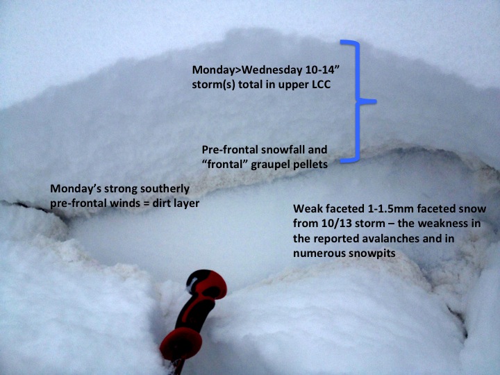
(photo/synopsis - Hardesty) A slab of snow sitting on a weak layer - the ingredients for an avalanche. Most of northern and central Utah received early October snow, which has persisted (and weakened) only on the upper elevation northerly facing slopes, and is pockety in nature. This layering was quite sensitive last Tuesday and Wednesday, but is getting more stubborn as the snowpack has adjusted to the additional weight from the Monday/Tuesday foot of storm snow. On the other hand, the strong winds from later last week would have likely created some sensitive new wind drifts in the highest, steepest terrain. Those heading into the Cottonwoods may do well to avoid, say, the steepest terrain off the highest ridgelines (ie- the Baldy Chutes, American Fork Twins; etc).
|
| type | aspect/elevation | characteristics |
|---|

|
|
LIKELIHOOD
 LIKELY
UNLIKELY
SIZE
LARGE
SMALL
TREND
 INCREASING DANGER
SAME
DECREASING DANGER
|
|
description
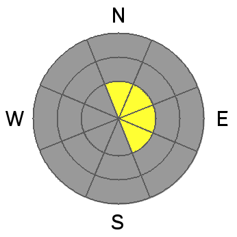
With snow totals approaching 8", shallow sluffs and wind drifts can be triggered in the steeper terrain above a conservative 9000'. Although these shallow sluffs and wind drifts may not pack too much of a punch, remember early season avalanche rides can be more traumatic due to the thinner snow cover. |
 |
weather We'll continue to be under a cold, moist northwesterly flow through about mid-week. Expect another 1-3" over the next 48 hours. A weak amplitude ridge and warmer temps build for late Wed/Thurs with another quick hitter moving through on Friday. Temps will be in the single digits to teens through the next couple days with winds generally in the 15-20mph range along the higher ridgelines. The longer range models depict another storm on the horizon for early next week. |
| general announcements If you trigger an avalanche in the backcountry - especially if you are adjacent to a ski area – please call the following teams to alert them to the slide and whether anyone is missing or not. Rescue teams can be exposed to significant hazard when responding to avalanches, and do not want to do so when unneeded. Thanks. Salt Lake and Park City – Alta Central (801-742-2033), Canyons Resort Dispatch (435-615-3322) Twitter Updates for your mobile phone - DETAILS UDOT canyon closures UDOT at (801) 975-4838 Remember your information can save lives. If you see anything we should know about, please participate in the creation of our own community avalanche advisory by submitting snow and avalanche conditions. You can also call us at 801-524-5304 or 800-662-4140, email by clicking HERE, or include #utavy in your tweet. |