| During the month of April, Mark Miller will donate $75 to the charity of your choice (5 to chose from, including the Utah Avalanche Center!) Mark Miller Subaru has raised over $300k in the previous 6 Do Good Feel Good events. More Info here |  |
| During the month of April, Mark Miller will donate $75 to the charity of your choice (5 to chose from, including the Utah Avalanche Center!) Mark Miller Subaru has raised over $300k in the previous 6 Do Good Feel Good events. More Info here | |
| Advisory: Salt Lake Area Mountains | Issued by Evelyn Lees for Thursday - October 31, 2013 - 4:54pm |
|---|

|
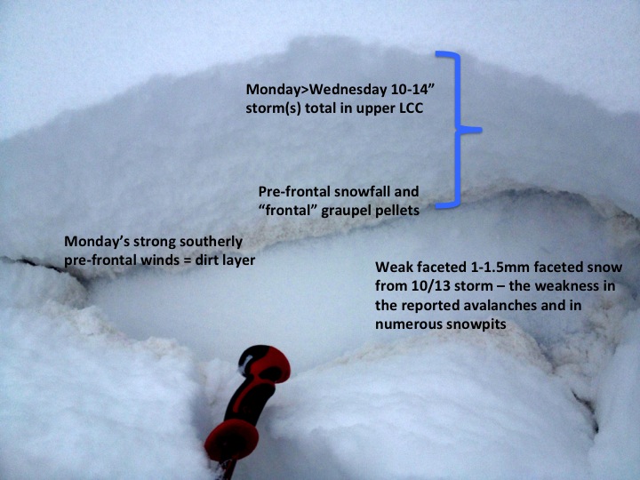
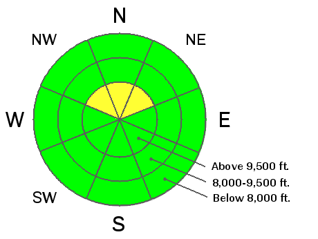
bottom line The avalanche danger is a pockety MODERATE on steep, upper elevation northerly facing slopes, where human triggered slides can be triggered. Slides to 1 to 1 1/2 feet deep can be triggered near the ground on faceted snow, and in steep terrain, catch and carry a person. The resulting rock scraping ride could cause a season ending injury. There have already been 2 close calls in the Colorado mountains on a similar snowpack - let's keep Utah off the accident page! A few human triggered wet sluffs at the mid elevations may be possible Friday afternoon as the day heats up and the sun comes out.
|
 |
special announcement The Utah Snow and Avalanche Workshop is being presented this Saturday, November 2nd. Details for the morning session for professionals can be viewed HERE and the afternoon session for everyone can be viewed HERE As resorts ready to open, please be courteous, obey any signage, and watch for workers and machines. |
 |
current conditions Total depths of 1 to 2 1/2 feet of snow exist on the upper elevation, northerly facing slopes in the upper Cottonwoods. Here the pack is supportable enough for decent turns, and keeps you off the ground on slopes with a smooth surface beneath. Upper elevation closed roads and meadows are other options to avoid the rocks. Snow depths on the Park City side are generally less than a foot. |
 |
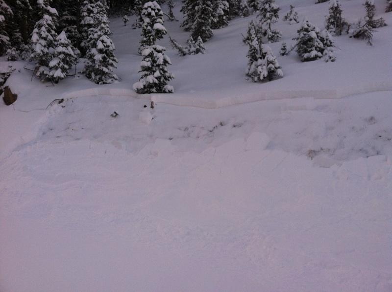
recent activity Enough snow for turns...enough snow to slide. A small avalanche cycle occurred Tuesday, October 29th - a mix of naturals and remotely triggered slides. All were above 10,000' on northerly facing slopes, failing on the faceted early October snow. A great way to highlight the Bull's Eye avalanche information is to click on Detailed Information, then Avalanches. (Check it out HERE). Below is a natural slide from upper Big Cottonwood.
|
| type | aspect/elevation | characteristics |
|---|

|
|
LIKELIHOOD
 LIKELY
UNLIKELY
SIZE
 LARGE
SMALL
TREND
 INCREASING DANGER
SAME
DECREASING DANGER
|
|
description
A slab of snow sitting on a weak layer - the ingredients for an avalanche. Most of northern and central Utah received early October snow, which has persisted (and weakened) only on the upper elevation northerly facing slopes, and is pockety in nature. This layering was quite sensitive Tuesday and Wednesday, but is getting more stubborn. Still, a person could trigger a slide on a steep slope, and the resulting ride would be nasty and most likely damaging.
|
 |
weather A weak weather disturbance will bring partly cloudy skies and a few snow flurries to the northern mountains tonight and Friday, with mostly clear skies by Friday afternoon. Lows tonight will be in the 20's, with highs on Friday near 40 at 10,000.. After significant warming on Friday and Saturday, another small storm is on the horizon - Saturday night through Monday. |
| general announcements If you trigger an avalanche in the backcountry - especially if you are adjacent to a ski area – please call the following teams to alert them to the slide and whether anyone is missing or not. Rescue teams can be exposed to significant hazard when responding to avalanches, and do not want to do so when unneeded. Thanks. Salt Lake and Park City – Alta Central (801-742-2033), Canyons Resort Dispatch (435-615-3322) Twitter Updates for your mobile phone - DETAILS UDOT canyon closures UDOT at (801) 975-4838 Remember your information can save lives. If you see anything we should know about, please participate in the creation of our own community avalanche advisory by submitting snow and avalanche conditions. You can also call us at 801-524-5304 or 800-662-4140, email by clicking HERE, or include #utavy in your tweet. |