Avalanche Advisory
| Advisory: Salt Lake Area Mountains | Issued by Bruce Tremper for April 22, 2013 - 6:39am |
|---|


Above 9,500 ft.
8,000-9,500 ft.
Below 8,000 ft.
|
bottom line 1) Avoid steep slopes with recent wind drifts, which will look smooth and rounded and often crack under your weight. Also test the new snow to see how well it's bonded by jumping on small test slopes. 2) Stay off of--and out from underneath--any slope approaching 35 degrees or steeper that is getting wet. There is a Moderate danger for these avalanche problems and locations today, and Low on other slopes.
|


 |
special announcement We have ended our regular morning advisories for the season but I will issue intermittent advisories as conditions warrant until about the end of April for the Salt Lake region only. I will still post observations from you each evening and early morning as well, so if you're getting out, please let everyone in our community know what you find. Most of the rest of our staff is off for the season--or will be soon as soon as some projects are completed and most of the ski resorts are closed for the season, so your feedback and observations are important.
|
 |
current conditions Temperatures are cooling rapidly this morning as the mostly dry cold front arrives. The ridge top wind is still stiff and blowing from the northwest 30, gusting to 40 on the most exposed peaks. Yesterday, the very warm temperatures and wind put a good sun crust on most aspects and elevations with the exception of the very high north facing slopes where some soft, dry snow still exists. This morning it's barely below freezing and temperatures should stay below freezing all day. Check the Snow Page for more details. |
 |
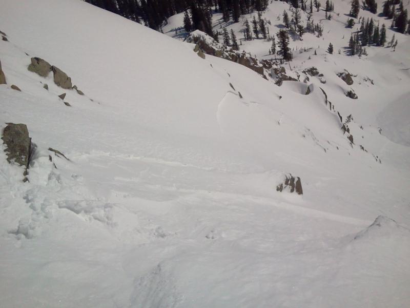
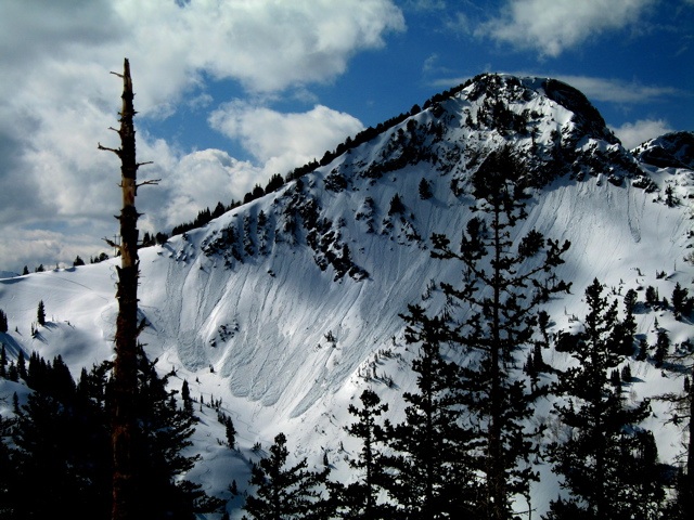
recent activity Yesterday there was two avalanche incidents, which caught two people but both are luckily OK. One was on the high, east face of Tuscarora and the other was on the south face of Little Superior. Both appeared to be recent wind slabs combined with lingering density inversion within the new snow.
Snowboader-triggered slide on Tuscarora. You can read the observations in the "All the Good Stuff" section of the website. In addition, several folks were out and we have a great photo gallery of avalanches from the storm on Saturday--that came in much more intense than we expected--and a few more wet avalanches and wind slabs from yesterday.
Thanks, again for all the crowdsourcing. I'm the only one left working this time of year and I've had a very tough week so I really appreciate everyone's observations.
|

Avalanche Problem 1over the next 24 hours
| type | aspect/elevation | characteristics |
|---|
 |


Above 9,500 ft.
8,000-9,500 ft.
Below 8,000 ft.
|
|
|
description
The wind is still blowing 30, gusting to 40 along the high peaks. The pre-existing snow got wet yesterday and is frozen this morning, so there is not a lot of new snow to blow around. Nevertheless, you could still find some fresh wind slabs especially on upper elevation lee terrain as well as some lingering wind slabs from yesterday. Always avoid steep slopes with recent wind deposits, which are usually very easy to recognize and avoid. They have a smooth surface texture and usually have a smooth, rounded shape. Note on the danger rose: almost no snow exists on southerly facing slopes below 8,000' but if an extra large avalanche releases on the slopes above, it could run down into bare terrain. Also, remember, most of the ski resorts are closed for the season with no avalanche control, so slopes that usually have moguls or grooming may avalanche just like a backcountry slope. |

Avalanche Problem 2over the next 8 hours
| type | aspect/elevation | characteristics |
|---|
 |


Above 9,500 ft.
8,000-9,500 ft.
Below 8,000 ft.
|
|
|
description
With the cooler temperatures, clouds and wind, in theory, wet activity should seize up today but you may still find some lingering wet snow problems from yesterday. Also, if the weather forecast is wrong, which regularly happens in the spring, then we could get more wet avalanches today on steep, sun exposed slopes.
|

 |
weather Today should be cloudy, with 30 mph wind from the northwest, gusting to 40 on the higher peaks and about half that speed on the lower ridge tops. Temperatures should remain around around freezing today and plunge down to 13 degrees overnight. The rest of the week looks mostly clear with a slow warming trend. We don't see any significant precipitation coming through the end of the month. Cottonwood Canyons Forecast, which you can find on the Snow Page. Always check your local NWS weather forecast, for example, here is the one for Alta. You can click on any spot in the state for a local forecast. You can also click on the satellite loops, radar loops or the hourly weather graph in the lower right of any forecast.
|
| general annoucements If you trigger an avalanche in the backcountry - especially if you are adjacent to a ski area – please call the following teams to alert them to the slide and whether anyone is missing or not. Rescue teams can be exposed to significant hazard when responding to avalanches, and do not want to do so when unneeded. Thanks. Salt Lake and Park City – Alta Central (801-742-2033), Canyons Resort Dispatch (435-615-3322) Twitter Updates for your mobile phone - DETAILS Subscribe to the daily avalanche advisory e-mail click HERE. UDOT canyon closures UDOT at (801) 975-4838 Remember your information can save lives. If you see anything we should know about, please participate in the creation of our own community avalanche advisory by submitting snow and avalanche conditions. You can also call us at 801-524-5304 or 800-662-4140, email by clicking HERE, or include #utavy in your tweet. Donate to your favorite non-profit –The Friends of the Utah Avalanche Center. The UAC depends on contributions from users like you to support our work. For a print version of this advisory click HERE.
This advisory is produced by the U.S. Forest Service, which is solely responsible for its content. It describes only general avalanche conditions and local variations always exist. Specific terrain and route finding decisions should always be based on skills learned in a field-based avalanche class. |