Avalanche Advisory
| Advisory: Salt Lake Area Mountains | Issued by Bruce Tremper for April 21, 2013 - 6:07am |
|---|


Above 9,500 ft.
8,000-9,500 ft.
Below 8,000 ft.
|
bottom line 1) Stay off of--and out from underneath--any slope approaching 35 degrees or steeper that is getting wet. There is a Moderate danger for these avalanche problems today, which could easily rise to Considerable with strong heating.
|


 |
special announcement We have ended our regular morning advisories for the season but I will issue intermittent advisories as conditions warrant until about the end of April for the Salt Lake region only. I will still post observations from you each evening and early morning as well, so if you're getting out, please let everyone in our community know what you find. Most of the rest of our staff is off for the season--or will be soon as soon as some projects are completed and most of the ski resorts are closed for the season, so your feedback and observations are important.
|
 |
current conditions It was a fast and furious storm yesterday, which will likely be the last significant precipitation until the end of April. Upper Little Cottonwood Canyon ended up with a foot of new snow with 1.65 inches of water equivalent. But the brunt of the storm hit the Logan and Ogden area mountains. Here are some water equivalent totals from the SNOTEL sites: Logan (Tony Grove) - 2.2 This morning it's warm with temperatures in the mid to upper 20's and the ridge top winds are still fairly stiff at 40 mph, gusting to 50 on the highest peaks and 20, gusting to 30 on most ridge tops. Check the Snow Page for more details. |
 |
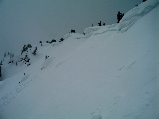
recent activity The reason I'm mostly bald is that I've torn out my hair forecasting these spring weather and the avalanche conditions they create. You get what you get and if you don't like the weather, wait 5 minutes. A lot of the avalanche advisories end up being a series of IF-THEN statements. "IF it snows like a bat out of hell with lots of wind, THEN, guess what, we'll have lots of sensitive soft slabs within the new snow," which is what I should have said yesterday. Yesterday morning between about 10:00 am and noon, the very high precipitation intensity rates created widespread, sensitive slabs within the new snow especially near ridges where the wind was the strongest. Thanks to nine of you who sent me great observations and photos of this activity yesterday, which you can always find on the "All the Good Stuff" section of the website. Most of these ran on density inversions within the new snow but some of them on the upper elevation, north facing slopes stepped deeper in to pre-existing faceted snow. Then, as is often the case in spring, as soon as the sun came out in the afternoon, the wet sluffs instantly started up. Here are a few select photos:
Thanks, again for all the crowdsourcing. You folks are the reason the UAC gets so many compliments.
|


Avalanche Problem 1over the next 8 hours
| type | aspect/elevation | characteristics |
|---|
 |
Above 9,500 ft.
8,000-9,500 ft.
Below 8,000 ft.
|
|
|
description
I'm hoping that avalanche conditions will be considerably tamer today but with temperatures forecast to rise into the 40's with sun today, we will almost certainly get wet sluffs and occasional wet slabs. Today, definitely stay off of--and out from underneath--steep slopes when they get soggy. IF it's warmer than forecast and IF the winds drop, THEN wet activity will be quite widespread and large, so I've colored the danger rose Considerable for slopes facing into the sun. Note on the danger rose: almost no snow exists on southerly facing slopes below 8,000' but if an extra large avalanche releases on the slopes above, it could run down into bare terrain. Also, remember, many of the ski resorts are closed for the season with no avalanche control, so slopes that usually have moguls or grooming may avalanche just like a backcountry slope. |

Avalanche Problem 2over the next 24 hours
| type | aspect/elevation | characteristics |
|---|
 |


Above 9,500 ft.
8,000-9,500 ft.
Below 8,000 ft.
|
|
|
description
The ubiquitous stiff wind is still blowing from the northwest this morning along the upper elevation ridges and peaks, 30, gusting to 40 in the most exposed locations. Wind always equals wind slabs on lee terrain. As always, avoid any steep slope with recent wind deposits, which will have a characteristic smooth surface texture and usually have a rounded shape. They often feel slabby, sound hollow and crack under your weight. Also, down out of the wind, in theory, the new snow should have quickly settled and stabilized, but you may find some lingering pockets.
|

 |
weather We should have mostly sunny skies today with temperatures rising into the lower to mid 40's. Stiff ridge top winds will continue to blow from the northwest 20, gusting to 30 and 30, gusting to 40 on the highest peaks. Overnight, we will likely have a few clouds with a mostly dry cold front on Monday morning, which could give us another inch or two of snow. The extended forecast call for, finally, an extended period of nice, seasonal weather until about the end of April. Cottonwood Canyons Forecast, which you can find on the Snow Page. Always check your local NWS weather forecast, for example, here is the one for Alta. You can click on any spot in the state for a local forecast. You can also click on the satellite loops, radar loops or the hourly weather graph in the lower right of any forecast.
|
| general annoucements If you trigger an avalanche in the backcountry - especially if you are adjacent to a ski area – please call the following teams to alert them to the slide and whether anyone is missing or not. Rescue teams can be exposed to significant hazard when responding to avalanches, and do not want to do so when unneeded. Thanks. Salt Lake and Park City – Alta Central (801-742-2033), Canyons Resort Dispatch (435-615-3322) Twitter Updates for your mobile phone - DETAILS Subscribe to the daily avalanche advisory e-mail click HERE. UDOT canyon closures UDOT at (801) 975-4838 Remember your information can save lives. If you see anything we should know about, please participate in the creation of our own community avalanche advisory by submitting snow and avalanche conditions. You can also call us at 801-524-5304 or 800-662-4140, email by clicking HERE, or include #utavy in your tweet. Donate to your favorite non-profit –The Friends of the Utah Avalanche Center. The UAC depends on contributions from users like you to support our work. For a print version of this advisory click HERE.
This advisory is produced by the U.S. Forest Service, which is solely responsible for its content. It describes only general avalanche conditions and local variations always exist. Specific terrain and route finding decisions should always be based on skills learned in a field-based avalanche class. |