Avalanche Advisory
| Advisory: Salt Lake Area Mountains | Issued by Bruce Tremper for April 19, 2013 - 6:43am |
|---|


Above 9,500 ft.
8,000-9,500 ft.
Below 8,000 ft.
|
bottom line 1) Continue to avoid steep slopes with recent wind drifts, which will look smooth and rounded and often crack under your weight. There is a Moderate danger for these avalanche problems today.
|


 |
special announcement We have ended our regular morning advisories for the season but I will issue intermittent advisories as conditions warrant until about the end of April for the Salt Lake region only. I will still post observations from you each evening and early morning as well, so if you're getting out, please let everyone in our community know what you find. Most of the rest of our staff is off for the season--or will be soon as soon as some projects are completed and most of the ski resorts are closed for the season, so your feedback and observations are important.
|
 |
current conditions Yesterday was blindingly sunny on very white, fresh snow. But temperatures remained very cold with just enough wind that it kept the snow surface from getting too soggy until the afternoon. Still, there is a thin sun crust on most slopes but still some very good riding conditions on upper elevation north facing slopes. This morning, it's cloudy and temperatures are 15 degrees warmer than yesterday morning and are around 20 degrees. Wind is still pretty stiff moderate from the west, blowing 20, gusting to 30 along the highest ridges. As always, check the Snow Page for more details. |
 |
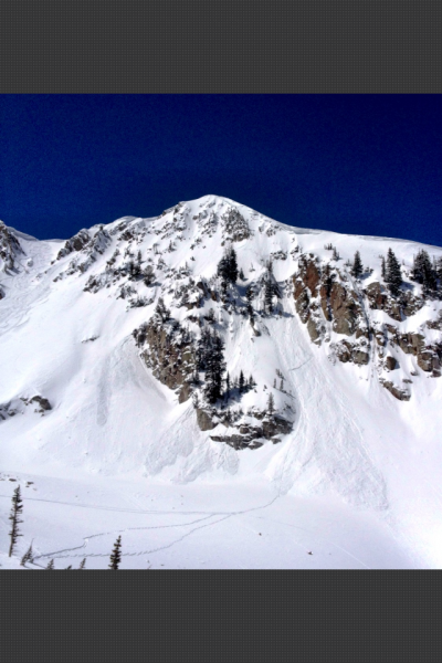
recent activity Someone was able to trigger a wind slab on a steep east facing Patsy Marley (photo). Luckily they self-arrested before they went over a cliff.
East facing Patsy Marley into Wolverine Cirque (between Brighton and Alta). Someone triggered a wind slab and luckily self-arrested above the cliff
|
Avalanche Problem 1over the next 8 hours
| type | aspect/elevation | characteristics |
|---|
 |


Above 9,500 ft.
8,000-9,500 ft.
Below 8,000 ft.
|
|
|
description
Quite a few sensitive wind slabs still litter the landscape above about 9,500' on many aspects. Luckily, they are easy to recognize and avoid. Look for the characteristic, smooth surface and rounded shape. They will often crack under your weight. As always, avoid any steep slope with recent wind deposits. Today's continued winds will continue to build more wind slabs. |

Avalanche Problem 2over the next 24 hours
| type | aspect/elevation | characteristics |
|---|
 |
Above 9,500 ft.
8,000-9,500 ft.
Below 8,000 ft.
|
|
|
description
I over forecast the wet activity yesterday. Luckily, the cold temperatures and wind kept a lid on it until the afternoon when several of the west facing slopes released naturally, as noted in Mark White's observation. But temperatures are much warmer today and we may even see low elevation rain today, so the possibility of wet avalanches continues especially at elevations below 9,500'. As usual, stay off of--and out from underneath--steep slopes if they become wet. Note on the danger rose: almost no snow exists on southerly facing slopes below 8,000'. |

 |
weather It looks like this will be the last gasp of winter until perhaps the end of April. We have yet another disturbance, which should give is yet a few more inches of snow overnight--perhaps 4-9 inches. Today should be mostly cloudy with steadily lowering clouds. Precipitation should begin this afternoon and continue overnight into Saturday Temperatures will warm up to freezing and the rain-snow line may be as high as 8,000' later today. Ridge top winds will continue to blow 20, gusting to 30 from the west. The extended forecast calls for clearing and more seasonal weather Sunday through next week. Cottonwood Canyons Forecast, which you can find on the Snow Page. Always check your local NWS weather forecast, for example, here is the one for Alta. You can click on any spot in the state for a local forecast. You can also click on the satellite loops, radar loops or the hourly weather graph in the lower right of any forecast.
|
| general annoucements If you trigger an avalanche in the backcountry - especially if you are adjacent to a ski area – please call the following teams to alert them to the slide and whether anyone is missing or not. Rescue teams can be exposed to significant hazard when responding to avalanches, and do not want to do so when unneeded. Thanks. Salt Lake and Park City – Alta Central (801-742-2033), Canyons Resort Dispatch (435-615-3322) Twitter Updates for your mobile phone - DETAILS Subscribe to the daily avalanche advisory e-mail click HERE. UDOT canyon closures UDOT at (801) 975-4838 Remember your information can save lives. If you see anything we should know about, please participate in the creation of our own community avalanche advisory by submitting snow and avalanche conditions. You can also call us at 801-524-5304 or 800-662-4140, email by clicking HERE, or include #utavy in your tweet. Donate to your favorite non-profit –The Friends of the Utah Avalanche Center. The UAC depends on contributions from users like you to support our work. For a print version of this advisory click HERE.
This advisory is produced by the U.S. Forest Service, which is solely responsible for its content. It describes only general avalanche conditions and local variations always exist. Specific terrain and route finding decisions should always be based on skills learned in a field-based avalanche class. |