

Avalanche Advisory
| Advisory: Salt Lake Area Mountains | Issued by Brett Kobernik for March 29, 2013 - 6:01am |
|---|


Above 9,500 ft.
8,000-9,500 ft.
Below 8,000 ft.
|
bottom line The avalanche danger is generally Low but may rise to Moderate this afternoon.
|


 |
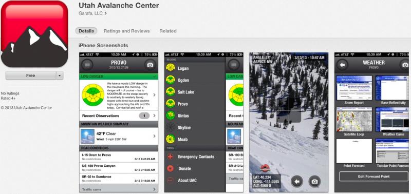
special announcement iPhone & iPad users: With help from Backcountry.com & Garafa, LLC, we now have a free mobile app that combines the best of the UAC advisories, observations, and weather summaries with National Weather Service products & UDOT road updates. This puts the tools you need for planning your day and your run in one handy mobile package. Check it out, tell your friends, and let us know what you think. http://utahavalanchecenter.org/apps
|
 |
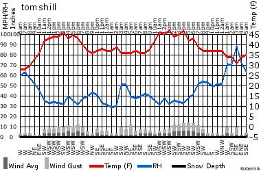
current conditions Today's advisory is basically a clone of yesterday. Temperatures behaved the same as they did the previous 24 hours. They were in the 40s and 50s in the mountains yesterday and only around freezing overnight. Winds are light and variable but we are under a west southwest flow. Most slopes have a sun crust with the exception of some lingering dry snow on the upper elevation steep northerly facing slopes that still ride pretty well. Check the Snow Page for details. Below is a 24hr weather chart from Tom's Hill (9000') in Mill D North of Big Cottonwood. More of these charts can be found HERE. . |
 |
recent activity No significant activity reported yesterday except for some larger rollerballs and a few wet sluffs on steep slopes as they heated up. More glide cracks are appearing as well. There were not many people in the backcountry yesterday. |
Avalanche Problem 1over the next 8 hours
| type | aspect/elevation | characteristics |
|---|
 |
Above 9,500 ft.
8,000-9,500 ft.
Below 8,000 ft.
|
|
|
description
It's another spring-like day today with very warm temperatures combined with afternoon convective clouds, which may produce a snow squall. So you will have to watch for a variety of different avalanche concerns today based on what the weather does: 1) Watch for wet sluffs, sensitive cornices and perhaps some glide avalanches with afternoon heating. More sun = more danger. Generally the avalanche danger from these problems will be relatively minor with the overall danger rating perhaps rising from Low this morning to Moderate by afternoon. |

 |
weather As Bruce's Mother in Law says, "Spring is a fight between winter and summer." We may see a bit more cloud cover today than yesterday. Temperatures should rise from freezing this morning to the mid 50's at the 8000 foot level and around 40 along the ridges again and then we could get some convective, afternoon showers. The extended forecast calls for more of the same spring weather through the weekend. |
| general annoucements Go to http://www.backcountry.com/utah-avalanche-center to get EVEN MORE DISCOUNTED tickets from our partners at Beaver Mountain and Sundance. All proceeds benefit the Utah Avalanche Center. If you trigger an avalanche in the backcountry - especially if you are adjacent to a ski area – please call the following teams to alert them to the slide and whether anyone is missing or not. Rescue teams can be exposed to significant hazard when responding to avalanches, and do not want to do so when unneeded. Thanks. Salt Lake and Park City – Alta Central (801-742-2033), Canyons Resort Dispatch (435-615-3322) Ogden – Snowbasin Patrol Dispatch (801-620-1017) Powder Mountain Ski Patrol Dispatch (801-745-3772 ex 123) Provo – Sundance Patrol Dispatch (801-223-4150) Dawn Patrol Forecast Hotline, updated by 05:30: 888-999-4019 option 8. Twitter Updates for your mobile phone - DETAILS Daily observations are frequently posted by 10 pm each evening. Subscribe to the daily avalanche advisory e-mail click HERE. UDOT canyon closures UDOT at (801) 975-4838 Wasatch Powderbird Guides does daily updates about where they'll be operating on this blog http://powderbird.blogspot.com/ . Remember your information can save lives. If you see anything we should know about, please participate in the creation of our own community avalanche advisory by submitting snow and avalanche conditions. You can also call us at 801-524-5304 or 800-662-4140, email by clicking HERE, or include #utavy in your tweet. Donate to your favorite non-profit –The Friends of the Utah Avalanche Center. The UAC depends on contributions from users like you to support our work. For a print version of this advisory click HERE. This advisory is produced by the U.S. Forest Service, which is solely responsible for its content. It describes only general avalanche conditions and local variations always exist. Specific terrain and route finding decisions should always be based on skills learned in a field-based avalanche class. |