

Avalanche Advisory
| Advisory: Salt Lake Area Mountains | Issued by Evelyn Lees for March 15, 2013 - 6:18am |
|---|


Above 9,500 ft.
8,000-9,500 ft.
Below 8,000 ft.
|
bottom line Once again, the avalanche danger will increase to CONSIDERABLE with day time heating. Both natural and human triggered wet avalanches are possible. The largest of these will be big enough to carry and injure or bury and kill a person. Avoid travel on and below steep slopes as the day and snow heats up.
|


 |
special announcement
|
 |
current conditions It was downright tropical overnight, with the temperatures at many mountain stations in the low 40s to 50 as of 4 am. The canyon bottoms and the highest peaks have temperatures in the 30s. Skies are partly to mostly cloudy as a bands of clouds move over the state. Winds are from the southwest and have picked up ever so slightly – a few stations averaging to 20 mph, with gusts into the low 30s. Any surface refreeze may be shorter lived than yesterday’s, depending a lot on cloud cover. |
 |
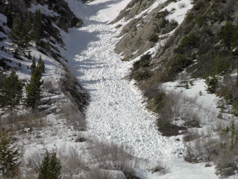
recent activity Natural wet snow sluffs occurred throughout the Wasatch, from Ogden south to Provo, on northeast through south through west facing slopes, well in to the evening. They were up to size D2, which means that they were large enough to bury and kill a person in their wet cement like debris. Mark White photo – Little Pine - wouldn't want to be buried in that!
|
Avalanche Problem 1over the next 10 hours
| type | aspect/elevation | characteristics |
|---|
 |
Above 9,500 ft.
8,000-9,500 ft.
Below 8,000 ft.
|
|
|
description
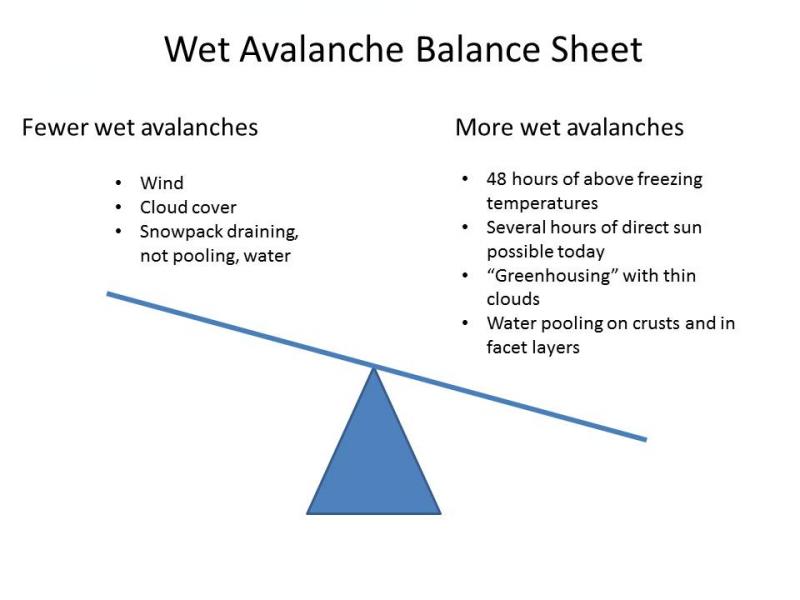
I expect another round of wet avalanches today, though increasing clouds and slightly stronger winds may partially offset the prolonged warm temperatures. In my mind, the Wet Avalanche Balance Sheet looks something like this:
There is a library of wet snow avalanche possibilities, both natural and human triggered, any of which could happen today. So take your pick -
|

 |
weather The high pressure over northern Utah will weaken slightly today, and temperatures will be slightly cooler. 10,000’ temperatures will cool from the current 40 degrees F to around 36 degrees by evening. 8,000’ highs will warm to near 50 today instead of close to 60. Winds will shift to the west or northwest, averaging about 15 mph, with gusts in the low 20s. The highest peaks could gust into the 30s. After a morning break in the cloud cover, high and mid-level clouds will increase again as a weak disturbance brings a slight chance of snow or rain tonight through Saturday. On Sunday, a cold front is forecast to cross northern Utah, significantly dropping temperatures and bring a small shot of snow. |
| general annoucements Go to http://www.backcountry.com/utah-avalanche-center to get tickets from our partners at Beaver Mountain, Canyons, Sundance, and Wolf Mountain. All proceeds benefit the Utah Avalanche Center. If you trigger an avalanche in the backcountry - especially if you are adjacent to a ski area – please call the following teams to alert them to the slide and whether anyone is missing or not. Rescue teams can be exposed to significant hazard when responding to avalanches, and do not want to do so when unneeded. Thanks. Salt Lake and Park City – Alta Central (801-742-2033), Canyons Resort Dispatch (435-615-3322) Ogden – Snowbasin Patrol Dispatch (801-620-1017) Powder Mountain Ski Patrol Dispatch (801-745-3772 ex 123) Provo – Sundance Patrol Dispatch (801-223-4150) Dawn Patrol Forecast Hotline, updated by 05:30: 888-999-4019 option 8. Twitter Updates for your mobile phone - DETAILS Daily observations are frequently posted by 10 pm each evening. Subscribe to the daily avalanche advisory e-mail click HERE. UDOT canyon closures UDOT at (801) 975-4838Wasatch Powderbird Guides does daily updates about where they'll be operating on this blog http://powderbird.blogspot.com/ .Remember your information can save lives. If you see anything we should know about, please participate in the creation of our own community avalanche advisory by submitting snow and avalanche conditions. You can also call us at 801-524-5304 or 800-662-4140, email by clicking HERE, or include #utavy in your tweet. Donate to your favorite non-profit –The Friends of the Utah Avalanche Center. The UAC depends on contributions from users like you to support our work. For a print version of this advisory click HERE. This advisory is produced by the U.S. Forest Service, which is solely responsible for its content. It describes only general avalanche conditions and local variations always exist. Specific terrain and route finding decisions should always be based on skills learned in a field-based avalanche class. |