

| Advisory: Salt Lake Area Mountains | Issued by Brett Kobernik for December 27, 2012 - 6:39am |
|---|


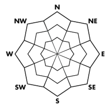
Above 9,500 ft.
8,000-9,500 ft.
Below 8,000 ft.
|
bottom line There is a CONSIDERABLE avalanche danger today. Experience along with careful route finding procedures and following safe backcountry protocol is a must today. If you don't fully understand what that statement includes then you should avoid being on or below any slopes over around 30 degrees in steepness.
|
 |
special announcement Little Cottonwood Canyon is closed for avalanche control work. Estimated re-opening is 8:30am. We will update through Twitter later this morning with any significant avalanche control results. |
 |
current conditions The current storm is verifying quite nicely in my opinion with around a foot of new snow or better in the Cottonwoods containing around ¾” of water with the mid portions of the canyons doing very well. The Provo area mountains got clobbered with 2 feet of snow and the Ogden area is doing quite well with 20” or so up there. Temperatures are in the teens and winds are fairly light from a westerly direction with some moderate speed gusts along the higher terrain. |
 |
recent activity There was one avalanche reported on Wednesday where a skier was caught and carried a short distance before being able to self arrest ending up uninjured. It was a pocket 50 feet wide and around 2.5 feet deep that ran a couple hundred vertical feet. It sounds like it was our newer snow that had been stirred up by the somewhat unusual wind direction from yesterday morning. DETAILS Also noteworthy, overnight, there was natural avalanche activity on the south facing slopes of Little Cottonwood Canyon. Some of these slides did make it into the tracks of the paths but not into the runnout zones below. |
| type | aspect/elevation | characteristics |
|---|
 |


Above 9,500 ft.
8,000-9,500 ft.
Below 8,000 ft.
|
|
|
description
We're going to keep it simple today people. There's been enough instability noted with this storm and with continued snowfall we need to use caution today. Ease into things gradually so you get a feel for how the new snow is behaving before just centerpunch any big lines. If you are experienced, pay attention and don't let you're guard down you should be able to travel around without much danger. However, I do expect to hear of human triggered avalanches today also, both loose snow and slab types. Watch where you are during any period of higher snowfall rates to make sure you're not in the runnout zone should a loose snow natural occur. Pay close attention to any areas where the winds have formed new soft slabs. This can be very subtle and hard to detect. |
| type | aspect/elevation | characteristics |
|---|
 |


Above 9,500 ft.
8,000-9,500 ft.
Below 8,000 ft.
|
|
|
description
The wise backcountry traveler will have patience with the thinner snowpack areas today and let the dust settle before venturing into steep slopes with old weaker snow. We've added almost another inch of water to some of these problem areas and it's best to let the snowpack adjust a bit before messing with it. This problem is more pronounced outside of the upper Cottonwoods. |
 |
weather We should see periods of snow today which should taper off somewhat mid day. I'm expecting another 6 inches in the Cottonwoods with 3/10ths of an inch of water by the time it winds down tonight. More is possible. Temperatures should remain in the teens and winds should remain fairly light switching more northerly as the day progresses. There is one last wave that may produce a few more snow showers just before this system completely exits our area by Friday. |
| general annoucements Go to http://www.backcountry.com/utah-avalanche-center to get tickets from our partners at Ala, Beaver Mountain, Brighton, Canyons, Deer Valley, Park City, Powder Mountain, Snowbasin, Snowbird, Solitude, Sundance, and Wolf Mountain. All proceeds benefit the Utah Avalanche Center. If you trigger an avalanche in the backcountry - especially if you are adjacent to a ski area – please call the following teams to alert them to the slide and whether anyone is missing or not. Rescue teams can be exposed to significant hazard when responding to avalanches, and do not want to do so when unneeded. Thanks. Salt Lake and Park City – Alta Central (801-742-2033), Canyons Resort Dispatch (435-615-3322) Ogden – Snowbasin Patrol Dispatch (801-620-1017) Powder Mountain Ski Patrol Dispatch (801-745-3773 ex 123) Provo – Sundance Patrol Dispatch (801-223-4150) Dawn Patrol Forecast Hotline, updated by 05:30: 888-999-4019 option 8. Twitter Updates for your mobile phone - DETAILS Daily observations are frequently posted by 10 pm each evening. Subscribe to the daily avalanche advisory e-mail click HERE. UDOT canyon closures UDOT at (801) 975-4838 Wasatch Powderbird Guides does daily updates about where they'll be operating on this blog http://powderbird.blogspot.com/ . Remember your information can save lives. If you see anything we should know about, please participate in the creation of our own community avalanche advisory bysubmitting snow and avalanche conditions. You can also call us at 801-524-5304 or 800-662-4140, or email by clicking HERE Donate to your favorite non-profit –The Friends of the Utah Avalanche Center. The UAC depends on contributions from users like you to support our work. For a print version of this advisory click HERE. This advisory is produced by the U.S. Forest Service, which is solely responsible for its content. It describes only general avalanche conditions and local variations always exist. Specific terrain and route finding decisions should always be based on skills learned in a field-based avalanche class. |