

Avalanche Advisory
| Advisory: Salt Lake Area Mountains | Issued by Brett Kobernik for December 22, 2012 - 6:30am |
|---|


Above 9,500 ft.
8,000-9,500 ft.
Below 8,000 ft.
|
bottom line A CONSIDERABLE danger still remains along the Park City Ridgeline, Mill Creek and other areas with a thin overall snowpack especially on northwest through east facing slopes. If you get onto slopes of 35 degrees in steepness in these areas it is likely you will trigger a large avalanche. Watch for areas with recent deposits of wind drifted snow throughout the entire region.
|


 |
current conditions The southwest winds backed off quite a bit overnight but probably will increase again as the day progresses. Temperatures are in the low 20s. The winds have done extensive damage to the snow surface conditions. |
 |
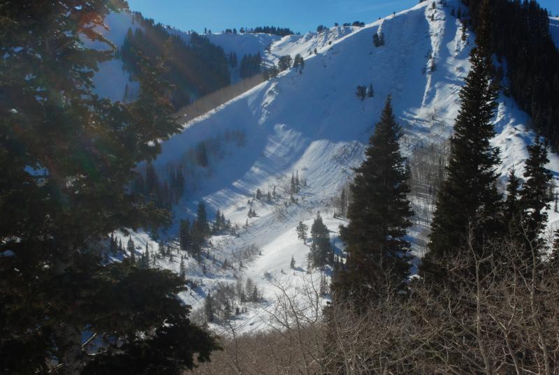
recent activity Two natural avalanches occurred on Friday during the wind event. One on Mt Baldy in Little Cottonwood Canyon and one in the Cinder Chutes outside of the Canyons Ski resort. Both avalanches were quite large. The Cinder Chutes slide continues to remind us of the poor snowpack structure along the Park City Ridgeline. DETAILS |
Avalanche Problem 1over the next 24 hours
| type | aspect/elevation | characteristics |
|---|
 |
Above 9,500 ft.
8,000-9,500 ft.
Below 8,000 ft.
|
|
|
description
Triggering an avalanche that breaks into buried weak faceted snow continues to pose the most threat to people today. This is more pronounced in thin snowpack areas such as but not limited to Mineral Fork of Big Cottonwood, the Park City Ridgeline and the drainages in Mill Creek. Slopes with an easterly component have been the most active but with all the southerly wind I would keep an eye on the northwest aspects as well. |

Avalanche Problem 2over the next 24 hours
| type | aspect/elevation | characteristics |
|---|
 |


Above 9,500 ft.
8,000-9,500 ft.
Below 8,000 ft.
|
|
|
description
The new wind slabs in their own will be more stubborn today but still may be sensitive to the weight of a person. Well versed travelers always avoid the new pillows and stay clear of slopes that have been recently loaded. |

 |
weather We will see increasing clouds during the day and southwest winds will increase in speed again. Ridgetop temperatures will get into the mid 20s. We may see a few snowflakes late in the day. A small disturbance moves through tonight bringing snow showers without much accumulation. A better looking system moves through Sunday night through Monday which should bring a foot of snow or better and an inch of water. |
| general annoucements Go to http://www.backcountry.com/utah-avalanche-center to get tickets from our partners at Ala, Beaver Mountain, Brighton, Canyons, Deer Valley, Park City, Powder Mountain, Snowbasin, Snowbird, Solitude, Sundance, and Wolf Mountain. All proceeds benefit the Utah Avalanche Center. If you trigger an avalanche in the backcountry - especially if you are adjacent to a ski area – please call the following teams to alert them to the slide and whether anyone is missing or not. Rescue teams can be exposed to significant hazard when responding to avalanches, and do not want to do so when unneeded. Thanks. Salt Lake and Park City – Alta Central (801-742-2033), Canyons Resort Dispatch (435-615-3322) Ogden – Snowbasin Patrol Dispatch (801-620-1017) Powder Mountain Ski Patrol Dispatch (801-745-3773 ex 123) Provo – Sundance Patrol Dispatch (801-223-4150) Dawn Patrol Forecast Hotline, updated by 05:30: 888-999-4019 option 8. Twitter Updates for your mobile phone - DETAILS Daily observations are frequently posted by 10 pm each evening. Subscribe to the daily avalanche advisory e-mail click HERE. UDOT canyon closures UDOT at (801) 975-4838 Wasatch Powderbird Guides does daily updates about where they'll be operating on this blog http://powderbird.blogspot.com/ . Remember your information can save lives. If you see anything we should know about, please participate in the creation of our own community avalanche advisory bysubmitting snow and avalanche conditions. You can also call us at 801-524-5304 or 800-662-4140, or email by clicking HERE Donate to your favorite non-profit –The Friends of the Utah Avalanche Center. The UAC depends on contributions from users like you to support our work. For a print version of this advisory click HERE. This advisory is produced by the U.S. Forest Service, which is solely responsible for its content. It describes only general avalanche conditions and local variations always exist. Specific terrain and route finding decisions should always be based on skills learned in a field-based avalanche class. |