25th Annual Black Diamond Fall Fundraising Party
Thursday, September 13; 6:00-10:00 PM; Black Diamond Parking Lot
25th Annual Black Diamond Fall Fundraising Party
Thursday, September 13; 6:00-10:00 PM; Black Diamond Parking Lot
| Advisory: Provo Area Mountains | Issued by Trent Meisenheimer for Sunday - December 4, 2016 - 7:09am |
|---|

|
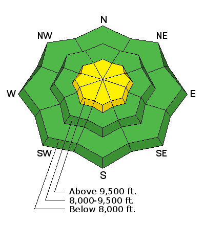
bottom line Avalanche danger is MODERATE on steep upper elevation slopes facing northwest, north and northeast, where a slide breaking to the ground could be triggered in localized places. There is also on MODERATE danger at the upper elevations on any steep slope where new drifts of wind blown snow have formed. You'll find a LOW avalanche danger on mid to lower elevation slopes that have not been effected by the wind. Have your backcountry party review their avalanche gear, do a training session, and travel one at a time on steep slopes. The consequences of getting caught in any avalanche in our thin, early-season snowpack include taking a ride over rocks and deadfall.
|
 |
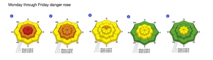
special announcement The Week in Review Blog. It’s a summary of the weather and avalanche events over the past 6 days, with separate sections for the Logan, Uinta, Wasatch and Manti/Skyline area mountains. An awesome way to get caught up on the important events before you head out and recreate in the snow
Please read, please share with others - UAC/UDOT Comms plan: New Avalanche Explosives Work Backcountry Closure Procedures Going Into Effect. |
 |
current conditions Skies are clear to partly cloudy this morning, with most trailhead temperatures in the low teens. Under a west northwest flow wind speeds at 11,000 ft are 30-35 mph gusting into 50's. Lose a little elevation, and the 10,000 ft winds are blowing 15-20 mph with gusts into the 30's in the central Wasatch and I expect the Provo mountains are similar. The total snow on the ground in the Provo area mountains is around 10" at the lower elevations and trail heads, and 17" to 22" at 8,000' - still a shallow early season snow pack that makes backcountry travel difficult off the snow covered roads. |
 |
recent activity No activity reported from the backcountry yesterday. |
| type | aspect/elevation | characteristics |
|---|

|
|
LIKELIHOOD
 LIKELY
UNLIKELY
SIZE
 LARGE
SMALL
TREND
 INCREASING DANGER
SAME
DECREASING DANGER
|
|
description
This morning the west-northwest winds are increasing and already stronger than yesterday. There is lots of loose powder to blow around, so identify and avoid any of the dense, cracky new wind drifts that form. The longer and deeper the cracks, the more sensitive and larger the wind slab is. This includes south facing terrain where the new wind drifted snow may not be bonding well to the slick sun crusts. I would approach steep wind drifted terrain with caution. These drifts will be most widespread along the higher ridge lines, and with the way the wind swirls around in the mountains, drifts will be found on a variety of aspects.
|
| type | aspect/elevation | characteristics |
|---|

|
|
LIKELIHOOD
LIKELY
UNLIKELY
SIZE
LARGE
SMALL
TREND
 INCREASING DANGER
SAME
DECREASING DANGER
|
|
description
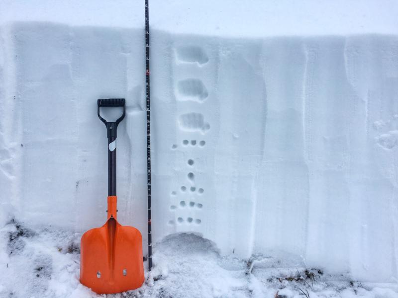
The early season snow lingered on northwest, north and northeast facing slopes, forming a faceted layer of snow on the ground. The most recent backcountry slide failing on the facets was Wednesday in the central Wasatch, on a slope with a smooth rock slab beneath the snow. It's hard to ignore the poor snowpack structure on certain aspects and elevations - see picture below.
Ian McCammon presented a paper on "A field method for identifying structural weaknesses in the snowpack" at the International Snow Science Workshop a few years back. It's worth a read if you want to geek out. However, the bottom line - weak snow does exists on upper north facing terrain and the snowpack structure remains poor in certain areas. It seems this weakness in the snowpack remains dormant for the time being as we have had no avalanche activity on this layer since Wednesday. Great powder exists on most other aspects, elevations and lower angle slopes. |
 |
weather Skies will become partly to mostly cloudy today, with the cloud bases lowering below the peaks this afternoon. The westerly winds have already increased this morning, and the high peaks are seeing speeds averaging 35 mph, with gusts into the 50s. Temperatures will warm this afternoon into the upper 20's at 9,000 ft ahead of a small storm that brushes by in the overnight hours. This two-part storm will bring wind and very cold temperatures in its wake. A small shot of snow Sunday night into Monday and again Tuesday morning will be welcomed and 2-5" of new snow is expected. |
| general announcements Remember your information can save lives. If you see anything we should know about, please help us out by submitting snow and avalanche conditions. You can also call us at 801-524-5304, email by clicking HERE, or include #utavy in your tweet or Instagram. To get help in an emergency (to request a rescue) in the Wasatch, call 911. Be prepared to give your GPS coordinates or the run name. Dispatchers have a copy of the Wasatch Backcountry Ski map. Backcountry Emergencies. It outlines your step-by-step method in the event of a winter backcountry incident. If you trigger an avalanche in the backcountry, but no one is hurt and you do not need assistance, please notify the nearest ski area dispatch to avoid a needless response by rescue teams. Thanks.
EMAIL ADVISORY If you would like to get the daily advisory by email you will need to subscribe here. DAWN PATROL Hotline updated daily by 5-530am - 888-999-4019 option 8. TWITTER Updates for your mobile phone - DETAILS UDOT canyon closures: LINK TO UDOT, or on Twitter, follow @UDOTavy, @CanyonAlerts or @AltaCentral Utah Avalanche Center mobile app - Get your advisory on your iPhone along with great navigation and rescue tools. Powderbird Helicopter Skiing - Blog/itinerary for the day Lost or Found something in the backcountry? - http://nolofo.com/ To those skinning uphill at resorts: it is critical to know the resort policy on uphill travel. You can see the uphill travel policy for each resort here. Benefit the Utah Avalanche Center when you shop from Backcountry.com or REI: Click this link for Backcountry.com or this link to REI, shop, and they will donate a percent of your purchase price to the UAC. Both offer free shipping (with some conditions) so this costs you nothing! Benefit the Utah Avalanche Center when you buy or sell on ebay - set the Utah Avalanche Center as a favorite non-profit in your ebay account here and click on ebay gives when you buy or sell. You can choose to have your seller fees donated to the UAC, which doesn't cost you a penny.
|


 This information does not apply to developed ski areas or highways where avalanche control is normally done. This advisory is from the U.S.D.A. Forest Service, which is solely responsible for its content. This advisory describes general avalanche conditions and local variations always exist.