| Please join us at the 23rd annual Black Diamond Fall Fundraiser Party Thursday Sept 15. Tickets are on sale now here, at the Black Diamond store & at REI. Special bonus raffle for online ticket purchasers! |
| Please join us at the 23rd annual Black Diamond Fall Fundraiser Party Thursday Sept 15. Tickets are on sale now here, at the Black Diamond store & at REI. Special bonus raffle for online ticket purchasers! |
| Advisory: Provo Area Mountains | Issued by Brett Kobernik for Wednesday - January 6, 2016 - 7:06am |
|---|

|
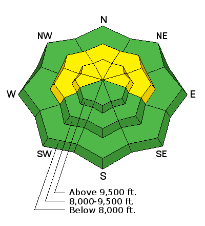
bottom line The overall avalanche danger is MODERATE. Human triggered avalanches are possible from recent wind loads and or deep weak layers failing in shallow snowpack areas. Accurate snowpack analysis and terrain selection are crucial. The avalanche danger is less pronounced in the mid and lower elevations.
|
 |
current conditions A couple of inches of snow fell in the Provo mountains over the last 24 hours. Southerly wind has been pretty well behaved. Temperatures are pretty mild with ridgetop readings in the low to mid 20s. |
 |
recent activity There was some minor wet loose snow slides in the lower elevations on Tuesday most notable along the road to Sundance. On a separate note, check out this BLOG POST by the always thought provoking Drew Hardesty. |
| type | aspect/elevation | characteristics |
|---|

|
|
LIKELIHOOD
 LIKELY
UNLIKELY
SIZE
 LARGE
SMALL
TREND
 INCREASING DANGER
SAME
DECREASING DANGER
|
|
description
The snowpack has been stabilizing and the anticipated new snow during the day today won't change the avalanche danger unless the wind increases more than expected. Below are some things to consider.
It's still tricky and it really takes very diligent snowpack and terrain assessment to stay safe right now. It's not an 'anything goes' situation.
|
 |
weather We're going to see a little snow today with better chances this afternoon and this evening. We might see 6 inches of medium density snow. This should improve riding conditions dramatically. It will be in a southerly flow and the southwest wind doesn't look like it will blow too hard. Wind speeds should stay in the light to moderate range. Temperatures will remain fairly mild in the mid 20s along the ridges. We should see another round of snow on Thursday night into Friday. This won't produce huge amounts of snow but these impulses might make riding conditions quite good without increasing the avalanche danger much. |
| general announcements Remember your information can save lives. If you see anything we should know about, please participate in the creation of our own community avalanche advisory by submitting snow and avalanche conditions. You can also call us at 801-524-5304, email by clicking HERE, or include #utavy in your tweet or Instagram. To get help in an emergency (to launch a rescue) in the Wasatch, call 911. Be prepared to give your GPS coordinates or the run name. Dispatchers have a copy of the Wasatch Backcountry Ski map. Backcountry Emergencies. It outlines your step-by-step method in the event of a winter backcountry incident. If you trigger an avalanche in the backcountry, but no one is hurt and you do not need assistance, please notify the nearest ski area dispatch to avoid a needless response by rescue teams. Thanks. Salt Lake and Park City – Alta Central (801-742-2033), Canyons Resort/PCMR Dispatch (435)615-1911 Snowbasin Resort Dispatch (801-620-1017), Powder Mountain Dispatch (801-745-3772 x 123). Sundance Dispatch (801-223-4150) EMAIL ADVISORY If you would like to get the daily advisory by email you will need to subscribe here. DAWN PATROL Hotline updated daily by 5-530am - 888-999-4019 option 8. Twitter Updates for your mobile phone - DETAILS UDOT canyon closures: LINK TO UDOT, or on Twitter, follow @UDOTavy, @CanyonAlerts or @AltaCentral Utah Avalanche Center mobile app - Get your advisory on your iPhone along with great navigation and rescue tools. Powderbird Helicopter Skiing - Blog/itinerary for the day Lost or Found something in the backcountry? - http://nolofo.com/ To those skinning uphill at resorts: it is your responsibility to know the resort policy on uphill travel. You can see the uphill travel policy for each resort here. IMPORTANT: Before skinning or hiking at a resort under new snow conditions, check in with Ski Patrol. Resorts can restrict or cut off access if incompatible with control and grooming operations. Benefit the Utah Avalanche Center when you shop from Backcountry.com or REI: Click this link for Backcountry.com or this link to REI, shop, and they will donate a percent of your purchase price to the UAC. Both offer free shipping (with some conditions) so this costs you nothing! Benefit the Utah Avalanche Center when you buy or sell on ebay - set the Utah Avalanche Center as a favorite non-profit in your ebay account here and click on ebay gives when you buy or sell. You can choose to have your seller fees donated to the UAC, which doesn't cost you a penny. This information does not apply to developed ski areas or highways where avalanche control is normally done. This advisory is from the U.S.D.A. Forest Service, which is solely responsible for its content. This advisory describes general avalanche conditions and local variations always exist. |