
| During the month of April, Mark Miller will donate $75 to the charity of your choice (5 to chose from, including the Utah Avalanche Center!) Mark Miller Subaru has raised over $300k in the previous 6 Do Good Feel Good events. More Info here |  |
| During the month of April, Mark Miller will donate $75 to the charity of your choice (5 to chose from, including the Utah Avalanche Center!) Mark Miller Subaru has raised over $300k in the previous 6 Do Good Feel Good events. More Info here | |
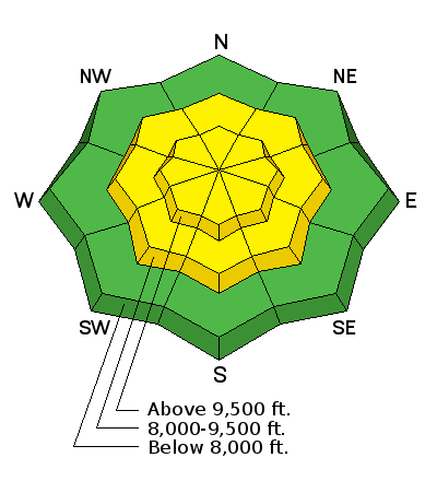
| Advisory: Provo Area Mountains | Issued by Bruce Tremper for Monday - December 29, 2014 - 7:01am |
|---|

|
bottom line The avalanche danger is Moderate (Yellow, Level 2) today. Within the new snow you will see sluffs and occasional soft slabs. There's still the chance to trigger a large, deep avalanche on upper elevation slopes that face northwest, north, northeast and east. Tomorrow, watch for wind drifting from canyon winds and along the foothills.
|
 |
special announcement This SHORT VIDEO is an insightful look into the world of veteran Snowbasin ski patroller, GR Fletcher. Ogden-based filmmaker Chris Morgan followed GR during a morning of avalanche control work on the mountain as he explained what motivates him to continue as a patroller after over twenty years on the job. |
 |
current conditions Yup, this is the kind of snow that entices people from all over the world to become regular visitors or permanent residents of Utah. I know, it happened to me in 1970....another story. This very cold, moist, unstable, northwest flow, favors upper Little Cottonwood Canyon and mid Big Cottonwood Canyon. Alta has storm totals of 16 inches since yesterday morning and most other places outside the sweet spot are closer to 6-8 inches including Sundance. The snow weighs almost nothing and the wind has been very well behaved. It's another call-in-sick-to-work day but bring your warm duds, mittens and something to cover your face. It's barely below zero on the ridge tops and single digits at 8,000'. It's supposed to be even colder tomorrow with canyon winds developing north of Salt Lake City. |
 |
recent activity We did not hear about any significant activity from yesterday except the usual sluffs and soft slabs within the new snow.
|
| type | aspect/elevation | characteristics |
|---|

|
|
LIKELIHOOD
 LIKELY
UNLIKELY
SIZE
 LARGE
SMALL
TREND
 INCREASING DANGER
SAME
DECREASING DANGER
|
|
description
In places where the most new snow has piled up over the past 24 hours, you can expect to see sluffs and occasional soft slabs within the new snow. Especially with high precipitation rates, the new snow tends to get slabby and cranky for a few hours. The sluffs could be long running and fast. The slabs will be mostly soft and relatively manageable but don't let either of them catch you in high consequence terrain. |
| type | aspect/elevation | characteristics |
|---|

|
|
LIKELIHOOD
 LIKELY
UNLIKELY
SIZE
 LARGE
SMALL
TREND
INCREASING DANGER
SAME
DECREASING DANGER
|
|
description
Our problem child, the persistent slab, continues to make us suspicious. The culprit weak layer is now buried 1-2 feet deep and under a stiff slab, so it's hard to trigger but if you do, it's a very large avalanche. The most suspect areas include thin, rocky, steep slopes, especially in places that have slid earlier in the season. But the pre-existing snowpack is so variable that there's a lot of uncertainty involved. If I can get all nerdy on you for a minute, here is a diagram that shows all the variables. Notice the circle is pretty big, meaning there is a lot of uncertainty. I don't like uncertainty especially when my life depends on it.
|
 |
weather Another day of cold smoke with mighty chilly temperatures--near zero on the ridge tops and single digits at 8,000'. Wind will remain light. We will continue to have a few squalls of lake effect snow mostly in the Cottonwood Canyons that will add a few more inches of very low density, blower powder. The storm will slowly wind down today with skies becoming increasingly clear. Tuesday looks like even colder temperatures but what concerns me more is that the upper flow should turn northeasterly and we should develop some strong canyon winds mostly north of Salt Lake City tomorrow. This could dramatically spike our avalanche danger because of wind drifting especially at low elevations along the canyon mouths and foothills where people are not used to seeing avalanches. The extended forecast calls for a week of rest with clear skies before another chance of snow next week about this time. |
| general announcements Remember your information can save lives. If you see anything we should know about, please participate in the creation of our own community avalanche advisory by submitting snow and avalanche conditions. You can also call us at 801-524-5304, email by clicking HERE, or include #utavy in your tweet or Instagram. If you trigger an avalanche in the backcountry - especially if you are adjacent to a ski area – please call the following teams to alert them to the slide and whether anyone is missing or not. Rescue teams can be exposed to significant hazard when responding to avalanches, and do not want to do so when unneeded. Thanks. Salt Lake and Park City – Alta Central (801-742-2033), Canyons Resort Dispatch (435-615-3322) Snowbasin Resort Dispatch (801-620-1017), Powder Mountain Dispatch (801-745-3772 x 123). Sundance Dispatch (801-223-4150) EMAIL ADVISORY If you would like to get the daily advisory by email you will need to subscribe here. DAWN PATROL Hotline updated daily by 5-530am - 888-999-4019 option 8. Twitter Updates for your mobile phone - DETAILS UDOT canyon closures: LINK TO UDOT, or on Twitter, follow @UDOTavy, @CanyonAlerts or @AltaCentral Utah Avalanche Center mobile app - Get your advisory on your iPhone along with great navigation and rescue tools. Wasatch Powderbird Guides Blog/Itinerary for the Day. Lost or Found something in the backcountry? - http://nolofo.com/ Discount lift tickets are now available at Backcountry.com with more resorts to come soon. Thanks to Ski Utah and the Utah Resorts. All proceeds go towards paying for Utah Avalanche Center avalanche and mountain weather advisories. To those skinning uphill at resorts: it is your responsibility to know the resort policy on uphill travel. You can see the uphill travel policy for each resort here. IMPORTANT: Before skinning or hiking at a resort under new snow conditions, check in with Ski Patrol. Resorts can restrict or cut off access if incompatible with control and grooming operations. Benefit the Utah Avalanche Center when you shop from Backcountry.com or REI: Click this link for Backcountry.com or this link to REI, shop, and they will donate a percent of your purchase price to the UAC. Both offer free shipping (with some conditions) so this costs you nothing! Benefit the Utah Avalanche Center when you buy or sell on ebay - set the Utah Avalanche Center as a favorite non-profit in your ebay account here and click on ebay gives when you buy or sell. You can choose to have your seller fees donated to the UAC, which doesn't cost you a penny. This information does not apply to developed ski areas or highways where avalanche control is normally done. This advisory is from the U.S.D.A. Forest Service, which is solely responsible for its content. This advisory describes general avalanche conditions and local variations always exist |


_3.jpg)
