| During the month of April, Mark Miller will donate $75 to the charity of your choice (5 to chose from, including the Utah Avalanche Center!) Mark Miller Subaru has raised over $300k in the previous 6 Do Good Feel Good events. More Info here |  |
| During the month of April, Mark Miller will donate $75 to the charity of your choice (5 to chose from, including the Utah Avalanche Center!) Mark Miller Subaru has raised over $300k in the previous 6 Do Good Feel Good events. More Info here | |
| Advisory: Provo Area Mountains | Issued by Drew Hardesty for Wednesday - January 22, 2014 - 7:13am |
|---|

|
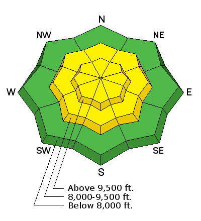
bottom line Many areas have a LOW danger. Localized areas of MODERATE danger exist on steep west to north to southeasterly facing slopes above about 8500'. Human triggered slides 1-3' deep are unlikely, yet possible in specific areas. If you want to avoid even these odds, choose slopes well less than 35 degrees in steepness with nothing steeper above. The danger of wet avalanche activity will, like clockwork, rise to MODERATE on the steep sunlit slopes with daytime warming.
|
 |
special announcement
FOCUS GROUP PARTICIPANTS NEEDED! We are trying to learn more about sidecountry riding and need your help. If you are between 17 – 30 years old, sometimes use lifts to get into the backcountry, and have little or no formal avalanche training, we want you to be a part of a focus group in SLC Feb 4. This will help us learn how to make avalanche education more relevant to you and those you ride with. We'll have FREE SKULLCANDY GEAR and pizza for all who join us for 2 hours. Hit us up if you think you fit the bill, [email protected]. PLEASE SHARE THIS with people you think might fit that description. |
 |
current conditions Same as it ever was. We're staring down the barrel of maybe another two weeks of high pressure. Never mind this little disturbance that rolls through tonight into tomorrow...it's a little cut-off "storm" that looks like it got lost or fell out of the pocket of the main flow of storms well off to the north. Asked what he did during the revolution, the Chinese master poet ** said, simply, "I went for a walk." These are good days for a long walk. Easy mountain weather, fair coverage, good conditions - what's not to like? Skies are clear, the northwesterly winds are light, and temps are in the upper teens and mid-20s. High pressure will make aesthetes of us all. Note the photos and observations of interesting snow behaviour, below. (Staff, Gagne, Smith)
|
 |
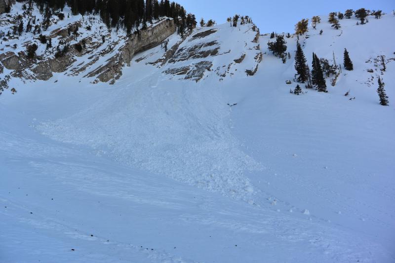
recent activity What I take to be a Glide-Slab avalanche released naturally in the Salt Lake mountains overnight Monday into early Tuesday. Noted by long-time observer Fred Staff (his photo), the Raymond Slabs (Piece of Pie) released 2-3' deep and 125' wide on a steep northeast facing "slope" at 9800'. I say "Glide" because the slab is usually littered with glide cracks that one has to hop-scotch over when skiing or riding the flatiron...and there's nothing I can think of that could support any other type of natural release. I've been surprised before. For more info on Glide Releases, check out our Avalanche Encyclopedia and click on Glide (cool animation). It should be noted that glides may be the least understood avalanche type of all.
|
| type | aspect/elevation | characteristics |
|---|

|

|
LIKELIHOOD
 LIKELY
UNLIKELY
SIZE
 LARGE
SMALL
TREND
 INCREASING DANGER
SAME
DECREASING DANGER
|
|
description
Everyday the likelihood and spatial extent of triggering one of these persistent or deep slab avalanches diminishes, albeit slightly. The odds are low of triggering one of these slides, but remember not all avalanches are created equal. And not all Moderates are created equal. Collapsing and cracking are the exception now and far from the rule...and the latest avalanche was triggered only four days ago on the 18th. But it was an interesting avalanche - (here's more info on it). In time, this structure will again become completely dormant, only to reawaken during the next significant storm. |
| type | aspect/elevation | characteristics |
|---|

|
|
LIKELIHOOD
 LIKELY
UNLIKELY
SIZE
 LARGE
SMALL
TREND
 INCREASING DANGER
SAME
DECREASING DANGER
|
|
description
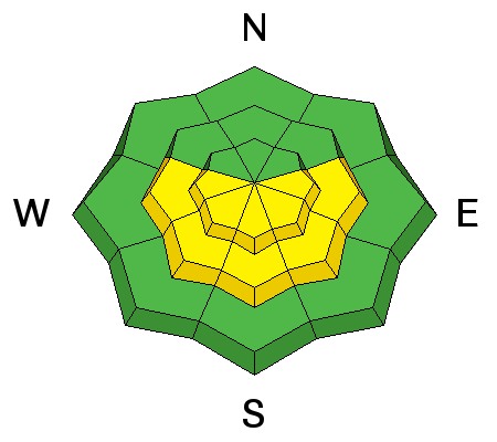
Spring skiing and riding in January. Start early and get off the steep, sunny slopes before the snow goes from soft to sloppy, and avoid slopes where you could get washed into a gully. Also avoid travel on or below the large slumping cornices. |
 |
weather We'll have clear skies with some clouds building late afternoon into early evening. A small disturbance drops in from the north tonight into early tomorrow, dropping temps about 10 degrees and increasing the winds from the east. Evanston and areas along the I-80 corridor and to the north will see easterly winds pushing 20-30mph but not for long. The ridge rebuilds for the weekend and through all of next week. |
| general announcements This information does not apply to developed ski areas or highways where avalanche control is normally done. This advisory is from the U.S.D.A. Forest Service, which is solely responsible for its content. This advisory describes general avalanche conditions and local variations always exist. If you trigger an avalanche in the backcountry - especially if you are adjacent to a ski area – please call the following teams to alert them to the slide and whether anyone is missing or not. Rescue teams can be exposed to significant hazard when responding to avalanches, and do not want to do so when unneeded. Thanks. Salt Lake and Park City – Alta Central (801-742-2033), Canyons Resort Dispatch (435-615-3322) Snowbasin Resort Dispatch (801-620-1017), Powder Mountain Dispatch (801-745-3772 x 123). Sundance Dispatch (801-223-4150) EMAIL ADVISORY We have switched to a new SLC email advisory system. If you would like to get the daily advisory by email, or if you have been getting the advisory by email since the beginning of the season and wish to continue, you will need to subscribe here. DAWN PATROL Hotline updated daily by 5-530am - 888-999-4019 option 8. Twitter Updates for your mobile phone - DETAILS UDOT canyon closures: LINK TO UDOT Utah Avalanche Center mobile app - Get your advisory on your iPhone along with great navigation and rescue tools.uned. Wasatch Powderbird Guides Blog/Itinerary for the Day. Lost or Found something in the backcountry? - http://nolofo.com/ Discount lift tickets are now available at Backcountry.com - Thanks to Ski Utah and the Utah Resorts. All proceeds go towards paying for Utah Avalanche Center avalanche and mountain weather advisories. To those skinning uphill at resorts: it is your responsibility to know the resort policy on uphill travel. Some allow uphill travel and have guidelines, some don't. Contact the Ski Patrol at each resort for details. IMPORTANT: Before skinning at a resort under new snow conditions, check in with Ski Patrol. Resorts can restrict or cut off access if incompatible with control and grooming operations. Benefit the Utah Avalanche Center when you shop from Backcountry.com or REI: Click this link for Backcountry.com or this link to REI, shop, and they will donate a percent of your purchase price to the UAC. Both offer free shipping (with some conditions) so this costs you nothing! Benefit the Utah Avalanche Center when you buy or sell on ebay - set the Utah Avalanche Center as a favorite non-profit in your ebay account here and click on ebay gives when you buy or sell. You can choose to have your seller fees donated to the UAC, which doesn't cost you a penny. Remember your information can save lives. If you see anything we should know about, please participate in the creation of our own community avalanche advisory by submitting snow and avalanche conditions. You can also call us at 801-524-5304 or 800-662-4140, email by clicking HERE, or include #utavy in your tweet or Instagram. |


_3.jpg)