| During the month of April, Mark Miller will donate $75 to the charity of your choice (5 to chose from, including the Utah Avalanche Center!) Mark Miller Subaru has raised over $300k in the previous 6 Do Good Feel Good events. More Info here |  |
| During the month of April, Mark Miller will donate $75 to the charity of your choice (5 to chose from, including the Utah Avalanche Center!) Mark Miller Subaru has raised over $300k in the previous 6 Do Good Feel Good events. More Info here | |
| Advisory: Provo Area Mountains | Issued by Evelyn Lees for Friday - January 10, 2014 - 6:59am |
|---|


|
bottom line The avalanche danger is HIGH on steep, wind drifted slopes at the upper elevations, and CONSIDERABLE on most other steep mid and upper elevation slopes. Dangerous avalanche conditions exist: New snow and wind slab avalanches are a given today on steep slopes. Slides also have the potential to break out into the weak layers mid pack and near the ground, creating very large avalanches. Backcountry travel is only recommended for people with excellent route finding and snowpack evaluation skills, who can stay off of and out from underneath steep slopes Many of the Provo ice climbs are in avalanche paths – be aware of what is above you. Natural avalanches can release and hit you.
|
 |
avalanche watch An avalanche watch has been continued for the Logan, Wasatch and Manti Skyline mountains of Utah. A series of storms with strong winds has increased the avalanche danger to HIGH on some slopes. The avalanche danger will continue to increase through the weekend. Backcountry travelers should avoid travel on and below steep slopes. The western Uintas have an Avalanche Warning. |
 |
current conditions Light snow continued to fall in many mountain locations overnight, with 1 to 4” inches of additional snow. Storm total are now 1 ½ to 2+ feet in the Cottonwoods, with water totals of 1 to 2”; 10 to 18” in the Ogden area mountains, and about a foot in the Park City and Provo area mountains. The northwesterly winds increased significantly for a while last night, with many stations averaging in the 25 to 40 mph range with gusts into the 70s. Currently, the winds have shifted back to the southwest, and are in the 15 to 25 mph range, with gusts to 60 along the highest ridges. Temperatures are warming, and in the teens to low 20s. |
 |
recent activity A natural new snow avalanche cycle occurred during the heavy snowfall in the afternoon – numerous class 2’s were reported – which are enough to carry and bury a person. The largest of these may have been up to 200’ wide and 2 to 3 feet deep. In addition, slides 1 to 2 feet deep were released with slope/ski cuts all day long at the resorts. Most were failing within the new snow, with a few breaking into loose surface facets. Yesterday’s few backcountry observations came from wise people, who stayed in lower angle, conservative terrain. |
| type | aspect/elevation | characteristics |
|---|

|
|
LIKELIHOOD
 LIKELY
UNLIKELY
SIZE
 LARGE
SMALL
TREND
 INCREASING DANGER
SAME
DECREASING DANGER
|
|
description
Sensitive wind slabs and new snow soft slab avalanches will continue to be the most widespread avalanche activity today. Strong winds overnight have drifted the snow into sensitive slabs – some of these may release naturally, as they did yesterday afternoon. Others are waiting for a trigger, which could be you. Any period of heavier snowfall or stronger winds will create a spike in the instability today. New snow avalanches are possible on steep slopes of all aspects. Any new snow slide has the potential to step down into the more deeply buried weak layers, creating a much larger, deeper slide. |
| type | aspect/elevation | characteristics |
|---|

|

|
LIKELIHOOD
 LIKELY
UNLIKELY
SIZE
 LARGE
SMALL
TREND
INCREASING DANGER
SAME
DECREASING DANGER
|
|
description
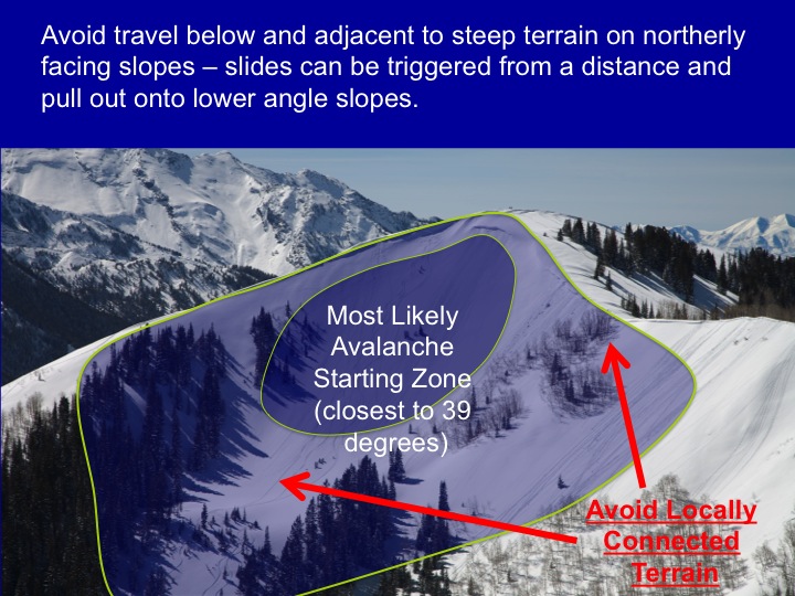
Multiple faceted weak layers, including those around buried rain and rime crusts, exist both mid pack and near the ground. These weak layers are gradually getting overloaded, and may be triggered by a person or a smaller slide. Any slide failing mid pack or near the ground would be large and probably unsurvivable. Some of these slides could be triggered from a distance or from below, so be aware of the steepness of the slopes you are connected to.
|
 |
weather Light snow will continue to fall throughout the day, adding another 6 to 9” to the storm totals. Densities will be slightly higher than yesterday, and the period of heaviest snowfall will be around noon. Winds will remain from the west to southwest for the next 24 hours, and speeds today will be in the 15 to 25 mph range, gusting to 30. The higher terrain will have significantly stronger wind speeds, with averages to 45 mph and gusts to 60. 10,000’ temperatures will slowly warm today. Strong warming will occur during a break in the storms on Saturday, with 10,000’ temperatures reaching near freezing. The final storm in the series arrives Saturday evening, with strong winds and a period of intense snowfall. |
| general announcements This information does not apply to developed ski areas or highways where avalanche control is normally done. This advisory is from the U.S.D.A. Forest Service, which is solely responsible for its content. This advisory describes general avalanche conditions and local variations always occur. If you trigger an avalanche in the backcountry - especially if you are adjacent to a ski area – please call the following teams to alert them to the slide and whether anyone is missing or not. Rescue teams can be exposed to significant hazard when responding to avalanches, and do not want to do so when unneeded. Thanks. Salt Lake and Park City – Alta Central (801-742-2033), Canyons Resort Dispatch (435-615-3322) Snowbasin Resort Dispatch (801-620-1017), Powder Mountain Dispatch (801-745-3772 x 123). Sundance Dispatch (801-231-4150) EMAIL ADVISORY Get the Salt Lake avalanche advisory emailed to you every morning. CLICK HERE FOR DETAILS DAWN PATROL Hotline updated daily by 5-530am - 888-999-4019 option 8. Twitter Updates for your mobile phone - DETAILS UDOT canyon closures: LINK TO UDOT Utah Avalanche Center mobile app - Get your advisory on your iPhone along with great navigation and rescue tools.uned. Wasatch Powderbird Guides Blog/Itinerary for the Day. They'll be up and running later this winter - Lost or Found something in the backcountry? - http://nolofo.com/ Discount lift tickets are now available at Backcountry.com - Thanks to Ski Utah and the Utah Resorts. All proceeds go towards paying for Utah Avalanche Center avalanche and mountain weather advisories. To those skinning uphill at resorts: it is your responsibility to know the resort policy on uphill travel. Some allow uphill travel and have guidelines, some don't. Contact the Ski Patrol at each resort for details. IMPORTANT: Before skinning at a resort under new snow conditions, check in with Ski Patrol. Resorts can restrict or cut off access if incompatible with control and grooming operations. Benefit the Utah Avalanche Center when you shop from Backcountry.com or REI: Click this link for Backcountry.com or this link to REI, shop, and they will donate a percent of your purchase price to the UAC. Both offer free shipping (with some conditions) so this costs you nothing! Benefit the Utah Avalanche Center when you buy or sell on ebay - set the Utah Avalanche Center as a favorite non-profit in your ebay account here and click on ebay gives when you buy or sell. You can choose to have your seller fees donated to the UAC, which doesn't cost you a penny. Remember your information can save lives. If you see anything we should know about, please participate in the creation of our own community avalanche advisory by submitting snow and avalanche conditions. You can also call us at 801-524-5304 or 800-662-4140, email by clicking HERE, or include #utavy in your tweet or Instagram. Ski Utah mobile snow updates: |


_3.jpg)