25th Annual Black Diamond Fall Fundraising Party
Thursday, September 13; 6:00-10:00 PM; Black Diamond Parking Lot

25th Annual Black Diamond Fall Fundraising Party
Thursday, September 13; 6:00-10:00 PM; Black Diamond Parking Lot
| Advisory: Ogden Area Mountains | Issued by Drew Hardesty for Tuesday - March 13, 2018 - 7:36am |
|---|
 |
special announcement How does an avalanche accident happen? What is it like to be caught? What can we learn? Read a first-hand account of the avalanche accident in the Meadow Chutes that happened on January 26th. The full accident report can be found here. We couldn't get out on the snow without the great support from Polaris, Ski Doo, and Arctic Cat as well as KTM and Timbersled. Our local dealers make it happen. Tri-City Performance, Weller Recreation, Northstar's Ultimate Outdoors, Big Pine and Morgan Valley Polaris. We use these machines to monitor the snowpack across the state of Utah. We also use these machines to teach life-saving classes. |
 |
current conditions Skies are partly cloudy with temps in the upper 20s to low 30s. Winds backed to the south overnight and are blowing 10mph with gusts to 15. All but due north mid and upper elevation snow surfaces will be crusted this morning. Decent quasi-corn is found mid-morning on the southerly aspects while soft turns in upper elevation cold snow are becoming an increasingly rare commodity. |
 |
recent activity Beyond standard and minor wet loose avalanches, the most significant avalanches are a few days old See the list below - |
| type | aspect/elevation | characteristics |
|---|


|


|

LIKELIHOOD
 LIKELY
UNLIKELY
SIZE
 LARGE
SMALL
TREND
 INCREASING DANGER
SAME
DECREASING DANGER
|
|
description
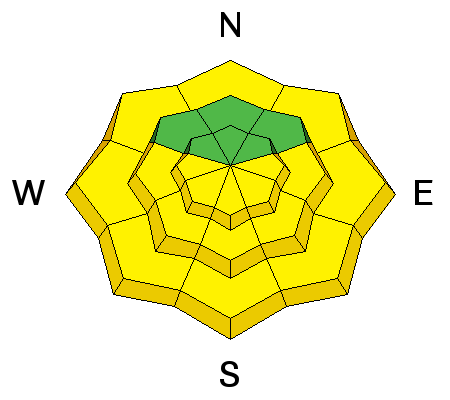
Poor snowpack structure exists above about 8000' on shady aspects and avalanches may be triggered by a skier or a rider, especially in thinner snowpack zones. Recent triggered avalanches in Coldwater Canyon to the north of Snowbasin and in the Bountiful area as well as natural avalanches on the Cutler and Willard headwalls are good indicators that persistent weak layers are still active. Staying off of and out from under slopes steeper than about 30 degrees mitigates this problem. |
| type | aspect/elevation | characteristics |
|---|


|


|

LIKELIHOOD
 LIKELY
UNLIKELY
SIZE
 LARGE
SMALL
TREND
 INCREASING DANGER
SAME
DECREASING DANGER
|
|
description
Wet Avalanches: As mountain temperatures skyrocket today, the snow will quickly thaw again and become wet and sloppy. Natural and human triggered wet loose (and potentially wet slab avalanches) are likely on the steepest aspects of all the sunlit slopes (and lower elevation shady ones). This is an easy problem to avoid. When the snow surface becomes damp and unsupportable or you start seeing roller balls cascading down from above, it's time to change to a cooler, more shady aspect. Cornices are increasingly sensitive with the sun and warm weather and often break back further than expected. Give them a wide berth and avoid travel below them. They may also - if large enough - be enough of a trigger to pry out deeper avalanches below. Roof-avalanches: Buildings are starting to shed their winter snow, so look up and avoid travel below steep roofs. |
 |
weather The ridge of high pressure moves off to the east as a large scale Pacific trof begins to cradle the west. A series of storms move through this week and into the weekend will bring snowfall to the moutains but details are shy at this time. For today, we'll see increasing clouds and southerly winds with mountain temps warming to the mid to upper 30s along the higher ridgelines...and in the ballpark of 50°F in the mid-elevations. |
| general announcements CLICK HERE FOR MORE GENERAL INFO AND FAQ The UAC has new support programs with Outdoor Research and Darn Tough. Support the UAC through your daily shopping. When you shop at Smith's, or online at Outdoor Research, REI, Backcountry.com, Darn Tough, Patagonia, NRS, Amazon, eBay a portion of your purchase will be donated to the FUAC. See our Donate Page for more details on how you can support the UAC when you shop. Benefit the Utah Avalanche Center when you buy or sell on eBay - set the Utah Avalanche Center as a favorite non-profit in your eBay account here and click on eBay gives when you buy or sell. You can choose to have your seller fees donated to the UAC, which doesn't cost you a penny This information does not apply to developed ski areas or highways where avalanche control is normally done. This advisory is from the U.S.D.A. Forest Service, which is solely responsible for its content. This advisory describes general avalanche conditions and local variations always occur. |