25th Annual Black Diamond Fall Fundraising Party
Thursday, September 13; 6:00-10:00 PM; Black Diamond Parking Lot
25th Annual Black Diamond Fall Fundraising Party
Thursday, September 13; 6:00-10:00 PM; Black Diamond Parking Lot
| Advisory: Ogden Area Mountains | Issued by Evelyn Lees for Saturday - March 10, 2018 - 7:35am |
|---|


|
bottom line Today the avalanche danger is MODERATE. Heightened avalanche danger exists on mid and upper elevation slopes for persistent slab. Evaluate the snow and terrain carfefully. The main concerns for today is:
Warm temperatures and periods of sun may heat the snow enough that wet loose avalanches could be triggered at the low elevations and on steep, sunny slopes. Roof-avalanches are occurring as snow slides off building roofs, with debris piles deep enough to bury and kill a person.
|
 |
special announcement We have discount lift tickets for Alta, Snowbird, Solitude, Snowbasin,and Powdermountain. Details and order information here. All proceeds from these go towards paying for avalanche forecasting and education
|
 |
current conditions Under partly cloudy skies, temperatures are in the 20s at the mid and upper elevations in the Ogden area mountains this morning and the northwesterly winds are unusually light – 5 to 10 mph averages. Even if you’re heading to the highest alpine peaks, the winds have dropped to less than 20 mph in the past few hours. Soft dense powder is rarity…remaining only on northerly facing slopes at the mid and upper elevations. All other aspects are crusted, and may be slow to soften today, though if they do, good spring skiing was reported yesterday on packed slopes.
|
 |
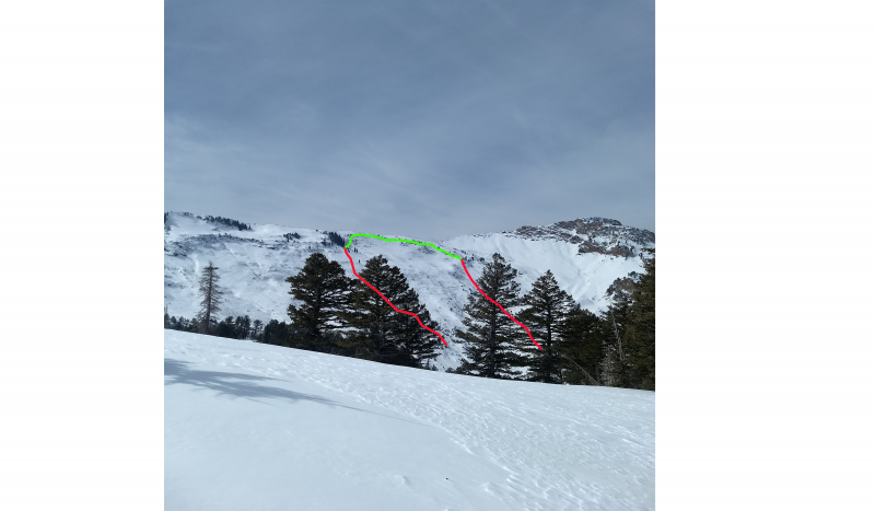
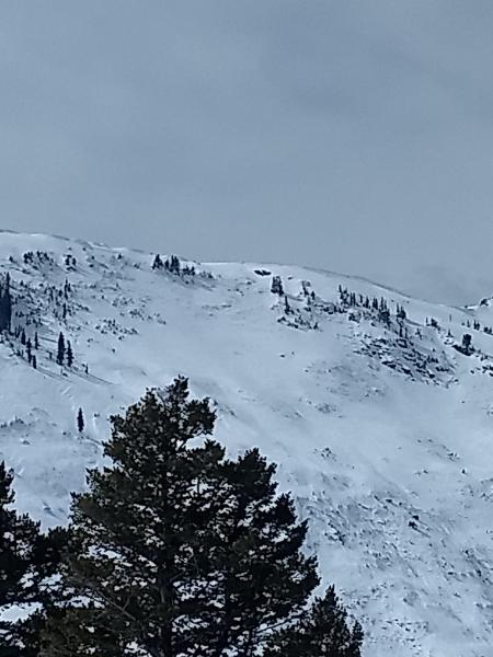
recent activity Here is Paige's review of activity from yesterday: In addition, resort control work yesterday in the Ogden area mountains did trigger a few soft slabs about a foot deep on northerly facing slopes, breaking into old snow. A human-triggered avalanche occurred on Wednesday in Coldwater Canyon (Technicolor) to the north of the Snowbasin boundary. The slide broke about 2' deep into old, faceted snow and ran about 1000' vertical confirming that our persistent weak layers are still active in specific areas where the snowpack is lower than average. Further south in the Bountiful Sessions mountains, explosive testing produced two large (size 3) avalanches on steep northeast facing slopes at roughly 9000', running fast and far and leaving significant debris piles. Kory Davis noted two large natural avalanches on the Cutler and Willard headwalls, respectively, that likely occurred earlier in the week. All of these slides confirm that our persistent weak layers are still active in specific areas in the Ogden zone. Lots of spatial variability with this particular issue should keep riders on low angle terrain on the northwest through east part of the compass at mid and upper elevations.
Cutler Headwall (pc: K Davis) |
| type | aspect/elevation | characteristics |
|---|

|

|
LIKELIHOOD
 LIKELY
UNLIKELY
SIZE
 LARGE
SMALL
TREND
 INCREASING DANGER
SAME
DECREASING DANGER
|
|
description
Persistent slab avalanches are notoriously unpredictable and are aptly named. Poor structure exists above about 8000' on shady aspects and avalanches may be triggered by a skier or a rider or by finding a thinner snowpack area. Recent triggered avalanches in Coldwater Canyon to the north of Snowbasin and in the Bountiful area as well as natural avalanches on the Cutler and Willard headwalls are good indicators that persistent weak layers are still active. Staying off of and out from under slopes steeper than about 30 degrees mitigates this problem. Video form Mark's visit to the Bountiful area Thursday where he found obvious weak snow. *A significant human-triggered avalanche failing on old, weak faceted snow occurred Thursday on Kessler Peak in Big Cottonwood Canyon - the in-depth observation, including photos and video, is worth a few minutes of your time. |
| type | aspect/elevation | characteristics |
|---|

|

|
LIKELIHOOD
 LIKELY
UNLIKELY
SIZE
 LARGE
SMALL
TREND
 INCREASING DANGER
SAME
DECREASING DANGER
|
|
description
Wet Loose: Another day of warm temperatures and potential sun could heat the snow surface on low elevation slopes and on sunny slopes facing east through south through northwesterly. So if the sun comes out for a prolonged period where you are and the snow gets wet and sloppy, it’s time to get off of and out from under steep slopes. Roof-avalanches: Buildings are starting to shed their winter snow, so look up and avoid travel below steep roofs. Dave Richards photo:
Cornices have softened and are sensitive, often breaking back further than expected, on to what looks like flat terrain. So give them a wide berth and avoid travel below them |
 |
weather A mild northwest flow will bring partly cloudy skies and warm temperatures to the mountains today. Mid elevation highs will be in the mid 30s to low 40s, and the northwesterly winds will be light at the mid elevations. Amazingly, speeds should remain light at the upper elevations, too. This disappointing dry, warm weather will last through at least midweek |
| general announcements CLICK HERE FOR MORE GENERAL INFO AND FAQ The UAC has new support programs with Outdoor Research and Darn Tough. Support the UAC through your daily shopping. When you shop at Smith's, or online at Outdoor Research, REI, Backcountry.com, Darn Tough, Patagonia, NRS, Amazon, eBay a portion of your purchase will be donated to the FUAC. See our Donate Page for more details on how you can support the UAC when you shop. Benefit the Utah Avalanche Center when you buy or sell on eBay - set the Utah Avalanche Center as a favorite non-profit in your eBay account here and click on eBay gives when you buy or sell. You can choose to have your seller fees donated to the UAC, which doesn't cost you a penny This information does not apply to developed ski areas or highways where avalanche control is normally done. This advisory is from the U.S.D.A. Forest Service, which is solely responsible for its content. This advisory describes general avalanche conditions and local variations always occur. |


 We Need Your Help With Social Media
 Here are the most recent