25th Annual Black Diamond Fall Fundraising Party
Thursday, September 13; 6:00-10:00 PM; Black Diamond Parking Lot
25th Annual Black Diamond Fall Fundraising Party
Thursday, September 13; 6:00-10:00 PM; Black Diamond Parking Lot
| Advisory: Ogden Area Mountains | Issued by Paige Pagnucco for Friday - March 9, 2018 - 5:59am |
|---|

|
bottom line Today the avalanche danger is MODERATE. Heightened avalanche danger exists on mid and upper elevation slopes for persistent slab and loose wet avalanches. Evaluate the snow and terrain carfefully. The two main concerns for today are:
Good riding conditions can still be found on low angle northerly terrain with no overhead hazard.
|
 |
special announcement We have discount lift tickets for Alta, Snowbird, Brighton, Solitude, Snowbasin,and Beaver Mountain. Details and order information here. All proceeds from these go towards paying for avalanche forecasting and education.
|
 |
current conditions Not much of a refreeze last night except at the highest elevations. Temps at 8000' are around 32 F having not gotten much colder overnight. Winds are out of the southwest 10-15 MPH with gusts in the 20's. Depending on elevation, sunny aspects will have either a breakable crust or be unconsolidated this morning. Good riding conditions can be found on low angle northerly terrain where the settled snow is still cold and fast. Unless I'm reading it incorrectly, Ben Lomond only has 42% of average SWE (snow water equivalent) for the season with 41" on the ground. The place historically known as the "wettest" place in Utah is, this year, one of the driest. (Have to consult with J. Steenburgh about this!)
Here are the most recent Ogden observations. |
 |
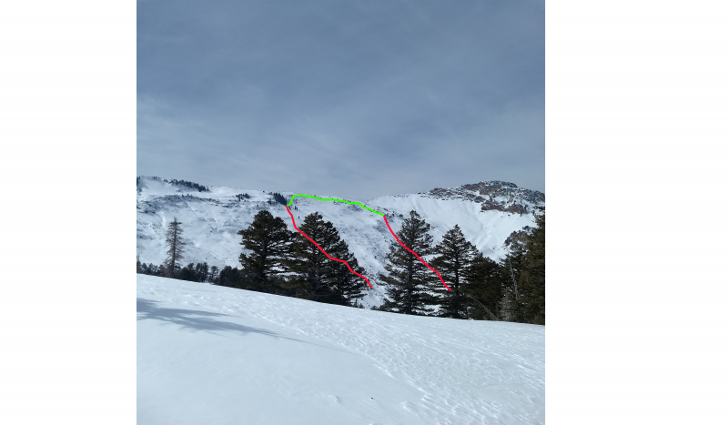
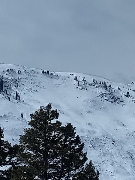
recent activity A human-triggered avalanche occurred on Wednesday in Coldwater Canyon (Technicolor) to the north of the Snowbasin boundary. The slide broke about 2' deep into old, faceted snow and ran about 1000' vertical confirming that our persistent weak layers are still active in specific areas where the snowpack is lower than average. Further south in the Bountiful Sessions mountains, explosive testing produced two large (size 3) avalanches on steep northeast facing slopes at roughly 9000', running fast and far and leaving significant debris piles. Kory Davis noted two large natural avalanches on the Cutler and Willard headwalls, respectively, that likely occurred earlier in the week. All of these slides confirm that our persistent weak layers are still active in specific areas in the Ogden zone. Lots of spatial variability with this particular issue should keep riders on low angle terrain on the northwest through east part of the compass at mid and upper elevations.
Cutler Headwall (pc: K Davis) |
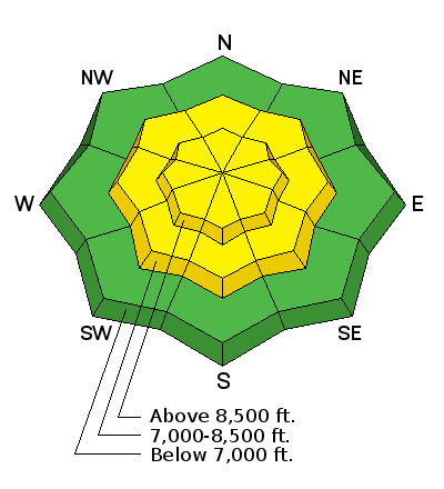
| type | aspect/elevation | characteristics |
|---|

|
|
LIKELIHOOD
 LIKELY
UNLIKELY
SIZE
 LARGE
SMALL
TREND
 INCREASING DANGER
SAME
DECREASING DANGER
|
|
description
Persistent slab avalanches are notoriously unpredictable and are aptly named. Poor structure exists above about 8000' on shady aspects and avalanches may be triggered by a skier or a rider or by finding a thinner snowpack area. Recent triggered avalanches in Coldwater Canyon to the north of Snowbasin and in the Bountiful area as well as natural avalanches on the Cutler and Willard headwalls are good indicators that persistent weak layers are still active. Staying off of and out from under slopes steeper than about 30 degrees mitigates this problem. Video form Mark's visit to the Bountiful area yesterday where he found obvious weak snow. *A significant human-triggered avalanche failing on old, weak faceted snow occurred yesterday on Kessler Peak in Big Cottonwood Canyon - the in-depth observation, including photos and video, is worth a few minutes of your time. |
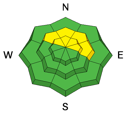
| type | aspect/elevation | characteristics |
|---|

|
|
LIKELIHOOD
LIKELY
UNLIKELY
SIZE
 LARGE
SMALL
TREND
 INCREASING DANGER
SAME
DECREASING DANGER
|
|
description
Warmer overnight temperatures and daytime heating can activate wet avalanche activity. Natural and human-triggered wet avalanches will be possible on warm slopes and may subsequently trigger still-stabilizing storm slabs on the way downslope. If you start seeing signs of instability like rollerballs or start sinking in wet snow deeper than your ankles, it's time to move to a cooler aspect or lower angle slope. I expect today's cloud cover will keep wet activity to a minimum. |
 |
weather It'll be mostly cloudy today with mountain temperatures nearing 40 F at 8000'. Winds will pick up just a bit this afternoon and turn more westerly ahead of a weak disturbance passing through the area tonight. A solid trace is the most we'll see. The weekend as well as early next week looks like classic Utah spring weather as high pressure sets in - clear cool nights, sunny days, and warm temps. Next chance for stormy weather is maybe mid week. |
| general announcements CLICK HERE FOR MORE GENERAL INFO AND FAQ The UAC has new support programs with Outdoor Research and Darn Tough. Support the UAC through your daily shopping. When you shop at Smith's, or online at Outdoor Research, REI, Backcountry.com, Darn Tough, Patagonia, NRS, Amazon, eBay a portion of your purchase will be donated to the FUAC. See our Donate Page for more details on how you can support the UAC when you shop. Benefit the Utah Avalanche Center when you buy or sell on eBay - set the Utah Avalanche Center as a favorite non-profit in your eBay account here and click on eBay gives when you buy or sell. You can choose to have your seller fees donated to the UAC, which doesn't cost you a penny This information does not apply to developed ski areas or highways where avalanche control is normally done. This advisory is from the U.S.D.A. Forest Service, which is solely responsible for its content. This advisory describes general avalanche conditions and local variations always occur. |


 We Need Your Help With Social Media