25th Annual Black Diamond Fall Fundraising Party
Thursday, September 13; 6:00-10:00 PM; Black Diamond Parking Lot
25th Annual Black Diamond Fall Fundraising Party
Thursday, September 13; 6:00-10:00 PM; Black Diamond Parking Lot
| Advisory: Ogden Area Mountains | Issued by Drew Hardesty for Thursday - February 22, 2018 - 7:20am |
|---|

|
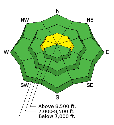
bottom line A MODERATE danger exists in localized terrain for human triggered avalanches 1-2' deep. The danger is most pronounced in steep wind drifted north through east facing terrain above about 8000'. If the winds pick up earlier than expected, look for and avoid any fresh wind slab development.
|
 |
special announcement We have discount lift tickets for Alta, Snowbird, Brighton, Solitude, Snowbasin, and Beaver Mountain. Details and order information here. All proceeds from these go towards paying for avalanche forecasting and education! |
 |
current conditions Skies are partly cloudy. Ridgetop winds are blowing 10-15mph from the south-southwest. Not that you'd run out to grab your Hawaiian shirt, but those stations below zero yesterday morning are now on the plus side. After the recent snowfall, many areas have pushed back to 40-50% of normal (though Monte Cristo is at 75%). Snow coverage sits at 35-40" up high on the Ogden skyline; whereas the terrain on the east side of the Huntsville and Eden valleys have 45-55" up high. Skiing and riding remain excellent, if a touch slow. Mark, Paige, and Evelyn all have reports from the Ogden area mountains from yesterday. |
 |
recent activity Ski area control teams had no results with explosive testing in fairly unskiied terrain yesterday. There were no reports of avalanches, collapsing or cracking from the backcountry either. |
| type | aspect/elevation | characteristics |
|---|

|
|
LIKELIHOOD
 LIKELY
UNLIKELY
SIZE
 LARGE
SMALL
TREND
 INCREASING DANGER
SAME
DECREASING DANGER
|
|
description
There is a fair bit of uncertainty with the lingering weaknesses both at the mid-pack (especially on the eastern edge of the Ogden mountains) and again with the more deeply buried early season weak layers. Tests and lack of avalanches hint at good stability and yet a general poor structure of snow with faceted grains drives a conservative approach to avoid thinner snowpack areas or more consequential terrain, at least above 8000'. |
 |
weather We'll see increasing clouds with the first of many generally weak weather systems on tap for northern Utah. For today, winds will be from the south and southwest at 10-15mph. Temps will be in the upper single digits up high,the mid to upper teens down low. We're expecting a number of quick moving systems over the next several days. Tonight into tomorrow may produce 3-6" with another quick hitter later Saturday and again on Monday. Temps again drop well below zero along the ridgelines on Saturday. And we thought winter was down for the count. It ain't how you start, it's how you finish. |
| general announcements CLICK HERE FOR MORE GENERAL INFO AND FAQ The UAC has new support programs with Outdoor Research and Darn Tough. Support the UAC through your daily shopping. When you shop at Smith's, or online at Outdoor Research, REI, Backcountry.com, Darn Tough, Patagonia, NRS, Amazon, eBay a portion of your purchase will be donated to the FUAC. See our Donate Page for more details on how you can support the UAC when you shop. Benefit the Utah Avalanche Center when you buy or sell on eBay - set the Utah Avalanche Center as a favorite non-profit in your eBay account here and click on eBay gives when you buy or sell. You can choose to have your seller fees donated to the UAC, which doesn't cost you a penny This information does not apply to developed ski areas or highways where avalanche control is normally done. This advisory is from the U.S.D.A. Forest Service, which is solely responsible for its content. This advisory describes general avalanche conditions and local variations always occur. |


