25th Annual Black Diamond Fall Fundraising Party
Thursday, September 13; 6:00-10:00 PM; Black Diamond Parking Lot
25th Annual Black Diamond Fall Fundraising Party
Thursday, September 13; 6:00-10:00 PM; Black Diamond Parking Lot
| Advisory: Ogden Area Mountains | Issued by Drew Hardesty for Tuesday - December 5, 2017 - 7:12am |
|---|

|
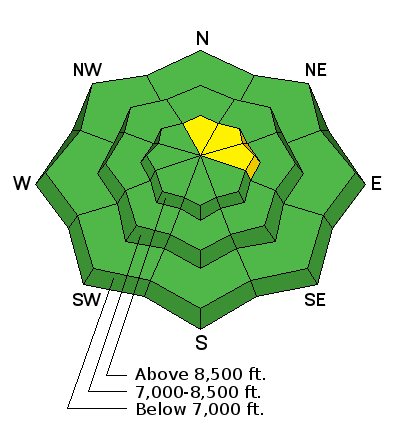
bottom line Areas of MODERATE danger exist in steep, mid to upper elevation terrain. The danger is most pronounced on wind drifted slopes facing north to east, generally above 9000'. Expect to note or initiate some point-release sluffs in the recent low density snow on slopes approaching 40° and steeper. As always, make a plan, go one at a time, and get out of the way at the bottom. Hot Tip! The best conditions will also be the safest: lower angle non-drifted terrain will be 5 star with the cold smoke on the underlying crusts.
|
 |
special announcement Looking for a great stocking stuffer for Christmas? Discount lift tickets for Alta, Snowbird, Brighton, Solitude, Deer Valley, Snowbasin,and Beaver Mountain are now available, donated by the resorts to benefit the Utah Avalanche Center. Details and order information here. These make a great holiday gift and all proceeds go towards paying for avalanche forecasting and education! There are still spots left for the FREE Avalanche Awareness for Women evening talk TONIGHT, December 5th, presented by the SLC REI, SheJumps and the Utah Avalanche Center. Sign up for free with REI HERE. Please abide by the uphill travel policies of the ski resorts. Info here. |
 |
current conditions Skies are clear under a waning super moon. Winds are northerly, blowing 5-10mph, gusting to 15. Temps are in the single digits and mid-teens. Storm totals are reportedly 8-14", with up to 6" at the trailheads...and this has greatly improved the skiing and riding conditions. Kory Davis has an excellent report from Monte Cristo from the past two days. 12/4/2017 Observation: Monte Cristo Ogden region 12/3/2017 Observation: Monte Cristo Ogden region |
 |
recent activity One experienced backcountry skier managed to find and intentionally trigger a couple fresh wind slabs 4-8" deep and 40' wide well below the Ogden skyline. One slab broke at his skis; another one was triggered from a distance. |
| type | aspect/elevation | characteristics |
|---|

|
|
LIKELIHOOD
 LIKELY
UNLIKELY
SIZE
 LARGE
SMALL
TREND
 INCREASING DANGER
SAME
DECREASING DANGER
|
|
description
The snow is mostly stable but for pockets of lingering wind slab and fast moving sluffs in the low density snow. While weak snow exists in the mid-pack, not enough snow and wind arrived to activate these persistent weaknesses. |
 |
weather Be grateful for this last storm, but we knew this was coming. A developing ridge of high pressure will begin to strangle the west coast and much of the intermountain west. We may not see a storm between now and Christmas. I hope I'm wrong. For now, we'll have mostly sunny skies, light northerly winds, and temperatures in the mountains rising toward freezing by the end of the week. The northerly winds may bump into the 20-25mph range Wednesday night with a storm passing to the northeast, but that's the handwriting on the wall. The bad news is that snow in the valley will only worsen the approaching inversion. |
general announcements
|


