| Please join us at the 23rd annual Black Diamond Fall Fundraiser Party Thursday Sept 15. Tickets are on sale now here, at the Black Diamond store & at REI. Special bonus raffle for online ticket purchasers! |
| Please join us at the 23rd annual Black Diamond Fall Fundraiser Party Thursday Sept 15. Tickets are on sale now here, at the Black Diamond store & at REI. Special bonus raffle for online ticket purchasers! |
| Advisory: Ogden Area Mountains | Issued by Drew Hardesty for Tuesday - March 29, 2016 - 7:17am |
|---|

|
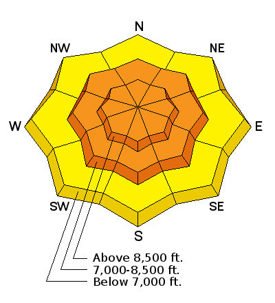
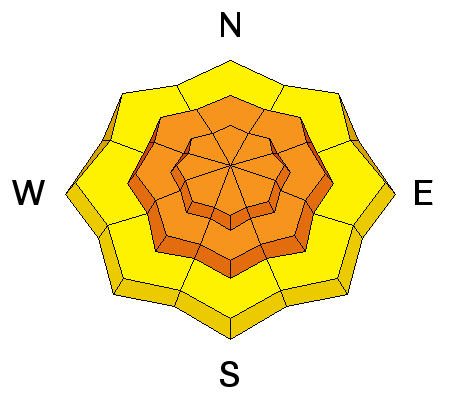
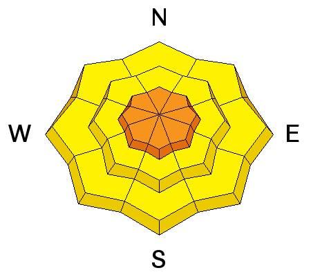
bottom line The danger was HIGH overnight and I expect it to be CONSIDERABLE throughout the day. Human triggered avalanches are probable on many slopes at the mid and upper elevations and may be most problematic and touchy on the steep west to north to east facing slopes. Cornices and avalanches may run on approach. Beware of unusual loading patterns from the southeast winds. I recommend a simple approach for today while things settle out - stick to sheltered slopes of 30° and less with nothing steeper above. A beginner's mind is required.
|
 |
special announcement Check out the Adventure and Gear Expo on April 8 & 9 at the Southtowne Expo Center. Use the code GOUAC to get a $2 discount on entrance tickets and the Adventure and Gear Expo will donate $2 to the UAC. http://www.adventuregearfest.com/ Spring powder special! We have reduced the price of donated Snowbasin lift tickets to $50 and Sundance tickets to $35, about half of window price. Take advantage of fresh powder on a fat snowpack and benefit the Utah Avalanche Center at the same time. We also haveone remaining Snowbird ticket for $84. Every penny spent on these donated tickets benefits the Utah Avalanche Center. A few links back to some recent blog posts by popular request -
|
 |
current conditions And it's still snowing. Quite the storm. Might be a few people calling in sick today. Hope you feel better soon. Snow totals so far are roughly 12" or so along the Ogden skyline and - favored by the southeast flow - 20" reported in terrain east of the mountain valleys. I'd imagine another 2-4" today. Winds burst in the overnight hours blowing 20-30mph with gusts into the 40s, but have lost a touch of steam, now blowing in the teens with gusts to 20. Temperatures are in the mid to upper 20s. |
 |
recent activity Yesterday: Not much sensitivity reported in the morning...but things changed in the afternoon. Shallow storm slabs, wind drifts, and sluffs were described as "touchy" with ski cuts during periods of higher snowfall intensity and a bump in winds in the afternoon. Heightened sensitivity noted on the northerly terrain with the snow presumably active on the weak pre-storm snow surfaces and some storm slabs provoking others to run as well. Undulating temperatures and crystal type may also have played a role yesterday. Video from Bruce Englehard in the central Wasatch below, representative of yesterday's conditions in much of the terrain. storm slab vid from bruce engelhard on Vimeo. Overnight and early this morning: periods of 1-2"/hour and elevated east to southeasterly winds likely led to another active, if deeper natural cycle though this hasn't been confirmed.
|
| type | aspect/elevation | characteristics |
|---|

|

|
LIKELIHOOD
 LIKELY
UNLIKELY
SIZE
 LARGE
SMALL
TREND
 INCREASING DANGER
SAME
DECREASING DANGER
|
|
description
Drifts may be buried under a few inches of harmless looking powder snow, but will be sensitive, potentially remotely triggered and may even step down into some facet/crust layering a few inches down lying dormant before the storm. Many drifts will be loaded in unusual terrain, owing to the south to east winds. Whereas many of the triggered avalanches yesterday were in the 6-10" deep range, I'd imagine they'd be more than twice that today and may break about above you. |
| type | aspect/elevation | characteristics |
|---|

|
|
LIKELIHOOD
LIKELY
UNLIKELY
SIZE
LARGE
SMALL
TREND
 INCREASING DANGER
SAME
DECREASING DANGER
|
|
description
Storm slabs will also remain sensitive to provocation and more pronounced in the mid and upper elevations in terrain that received (and continues to receive the most loading). Snowfall rates continued to be in the 1-2"/hour range overnight and will need more time to stabilize. Assume snow in terrain over 30° and moving toward 35-40° will move with human interaction. Don't overestimate your ability to ski cut steep terrain as older weak surface snow and thinly buried facet/crust combos may contribute to a more unpredictable avalanche character. |
| type | aspect/elevation | characteristics |
|---|

|
|
LIKELIHOOD
LIKELY
UNLIKELY
SIZE
LARGE
SMALL
TREND
 INCREASING DANGER
SAME
DECREASING DANGER
|
|
description
Fast moving sluffs can again be expected today on the steeper slopes. Note that debris piles from ski cuts yesterday of 2-3' deep may easily be twice that now. |
 |
weather We'll see continued snowfall throughout the morning with off and on showers throughout the day. Winds should be southeasterly at 15-20mph along the ridgelines. Temps with be in the upper teens up high, the mid to upper 20s down low. A weak "dirty" ridge builds in for the later part of the week with gradual warming into the weekend. |
| general announcements Remember your information can save lives. If you see anything we should know about, please help us out by submitting snow and avalanche conditions. You can also call us at 801-524-5304, email by clicking HERE, or include #utavy in your tweet or Instagram. To get help in an emergency (to request a rescue) in the Wasatch, call 911. Be prepared to give your GPS coordinates or the run name. Dispatchers have a copy of the Wasatch Backcountry Ski map. Backcountry Emergencies. It outlines your step-by-step method in the event of a winter backcountry incident. If you trigger an avalanche in the backcountry, but no one is hurt and you do not need assistance, please notify the nearest ski area dispatch to avoid a needless response by rescue teams. Thanks.
EMAIL ADVISORY If you would like to get the daily advisory by email you will need to subscribe here. DAWN PATROL Hotline updated daily by 5-530am - 888-999-4019 option 8. TWITTER Updates for your mobile phone - DETAILS UDOT canyon closures: LINK TO UDOT, or on Twitter, follow @UDOTavy, @CanyonAlerts or @AltaCentral Utah Avalanche Center mobile app - Get your advisory on your iPhone along with great navigation and rescue tools. Powderbird Helicopter Skiing - Blog/itinerary for the day Lost or Found something in the backcountry? - http://nolofo.com/ To those skinning uphill at resorts: it is critical to know the resort policy on uphill travel. You can see the uphill travel policy for each resort here. Benefit the Utah Avalanche Center when you shop from Backcountry.com or REI: Click this link for Backcountry.com or this link to REI, shop, and they will donate a percent of your purchase price to the UAC. Both offer free shipping (with some conditions) so this costs you nothing! Benefit the Utah Avalanche Center when you buy or sell on ebay - set the Utah Avalanche Center as a favorite non-profit in your ebay account here and click on ebay gives when you buy or sell. You can choose to have your seller fees donated to the UAC, which doesn't cost you a penny. This information does not apply to developed ski areas or highways where avalanche control is normally done. This advisory is from the U.S.D.A. Forest Service, which is solely responsible for its content. This advisory describes general avalanche conditions and local variations always exist. |


