| Please join us at the 23rd annual Black Diamond Fall Fundraiser Party Thursday Sept 15. Tickets are on sale now here, at the Black Diamond store & at REI. Special bonus raffle for online ticket purchasers! |
| Please join us at the 23rd annual Black Diamond Fall Fundraiser Party Thursday Sept 15. Tickets are on sale now here, at the Black Diamond store & at REI. Special bonus raffle for online ticket purchasers! |
| Advisory: Ogden Area Mountains | Issued by Mark Staples for Saturday - March 19, 2016 - 7:17am |
|---|

|
bottom line Today you can find generally safe avalanche conditions on many slopes. However there is a MODERATE avalanche danger on upper elevation slopes with wind slabs. Also, as the day progresses the danger will rise to MODERATE due to loose wet avalanches.
|
 |
special announcement PLEASE HELP guide our discussions of website maintenance, upgrades or possible changes in coming years. Take this brief survey. As a way of saying thanks we'll be raffling a free avalanche class and other free stuff like hats, beanies, water bottles, etc. Do you need lift tickets to Snowbird, Snowbasin, Sundance, or Nordic Valley? Purchase them HERE at reduced prices. Every penny on these donated tickets benefits the Utah Avalanche Center. Check out our Garage Sale! Chock full of sweet backcountry gear - you can find the goods on our Facebook page here. |
 |
current conditions Yesterday remained surprisingly cool. Slopes shaded from the sun and wind still have dry, soft snow. High temperatures yesterday reached the upper 30's to low 40's F though it felt a lot warmer in the sun. This morning tempertures at most elevations are in the low to mid 20's F. Winds are blowing 5-10 mph from the WNW with some gusts of 20 mph. A good summary of conditions can be found in recent obs HERE.
|
 |
recent activity Yesterday there was some notable avalanche activity. One was a skier-triggered wind slab in the mountains above Bountiful. It was 14 inches deep and 80 feet wide. Additionally a sizable avalanche caught 4 snowmobilers near Logan yesterday. Three were partially buried and one was fully buried but quickly rescued by his partners. Read more here.
|
| type | aspect/elevation | characteristics |
|---|

|

|
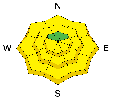
LIKELIHOOD
 LIKELY
UNLIKELY
SIZE
 LARGE
SMALL
TREND
 INCREASING DANGER
SAME
DECREASING DANGER
|
|
description
Wind slabs can be tricky. They become a little more stable each day but some stablize faster than others. Some wind slabs are resting on a few different layers including graupel and possibly some small facets which may be the reason people are still able to trigger them. Slopes with wind loading and some of these funky layers underneath are places to possibly trigger an avalanche.
|
| type | aspect/elevation | characteristics |
|---|

|
|
LIKELIHOOD
LIKELY
UNLIKELY
SIZE
LARGE
SMALL
TREND
 INCREASING DANGER
SAME
DECREASING DANGER
|
|
description
Today should be noticeably warmer than yesterday. Cool winds yesterday prevented the snow from warming up much but that should change today. Watch for loose wet snow avalanches mostly on east, south and west aspects and under exposed rocks. Even north facing slopes may see wet snow at lower elevations as temperatures rise today. Wet avalanches are all about timing. Conditions can change rapidly from hard frozen snow, to soft snow with decent riding, to wet and unstable snow very quickly. Increasing numbers of small roller balls of snow as in the photo below indicate that the snow is getting wet and losing strength.
Photo: B. Tremper
|
 |
weather Today will be warmer and calmer than yesterday with temperatures at 9000 feet reaching the upper 30's F and temperatures at 7-8,000 feet reaching 50 degrees F. Winds will calm a bit and blow about 5 mph. Similar conditions are expected Sunday, but winds should increase late Sunday as a storm with colder weather approaches. |
| general announcements Remember your information can save lives. If you see anything we should know about, please help us out by submitting snow and avalanche conditions. You can also call us at 801-524-5304, email by clicking HERE, or include #utavy in your tweet or Instagram. To get help in an emergency (to request a rescue) in the Wasatch, call 911. Be prepared to give your GPS coordinates or the run name. Dispatchers have a copy of the Wasatch Backcountry Ski map. Backcountry Emergencies. It outlines your step-by-step method in the event of a winter backcountry incident. If you trigger an avalanche in the backcountry, but no one is hurt and you do not need assistance, please notify the nearest ski area dispatch to avoid a needless response by rescue teams. Thanks.
EMAIL ADVISORY If you would like to get the daily advisory by email you will need to subscribe here. DAWN PATROL Hotline updated daily by 5-530am - 888-999-4019 option 8. TWITTER Updates for your mobile phone - DETAILS UDOT canyon closures: LINK TO UDOT, or on Twitter, follow @UDOTavy, @CanyonAlerts or @AltaCentral Utah Avalanche Center mobile app - Get your advisory on your iPhone along with great navigation and rescue tools. Powderbird Helicopter Skiing - Blog/itinerary for the day Lost or Found something in the backcountry? - http://nolofo.com/ To those skinning uphill at resorts: it is critical to know the resort policy on uphill travel. You can see the uphill travel policy for each resort here. Benefit the Utah Avalanche Center when you shop from Backcountry.com or REI: Click this link for Backcountry.com or this link to REI, shop, and they will donate a percent of your purchase price to the UAC. Both offer free shipping (with some conditions) so this costs you nothing! Benefit the Utah Avalanche Center when you buy or sell on ebay - set the Utah Avalanche Center as a favorite non-profit in your ebay account here and click on ebay gives when you buy or sell. You can choose to have your seller fees donated to the UAC, which doesn't cost you a penny. This information does not apply to developed ski areas or highways where avalanche control is normally done. This advisory is from the U.S.D.A. Forest Service, which is solely responsible for its content. This advisory describes general avalanche conditions and local variations always exist. |


