| Please join us at the 23rd annual Black Diamond Fall Fundraiser Party Thursday Sept 15. Tickets are on sale now here, at the Black Diamond store & at REI. Special bonus raffle for online ticket purchasers! |
| Please join us at the 23rd annual Black Diamond Fall Fundraiser Party Thursday Sept 15. Tickets are on sale now here, at the Black Diamond store & at REI. Special bonus raffle for online ticket purchasers! |
| Advisory: Ogden Area Mountains | Issued by Evelyn Lees for Thursday - March 17, 2016 - 7:22am |
|---|

|
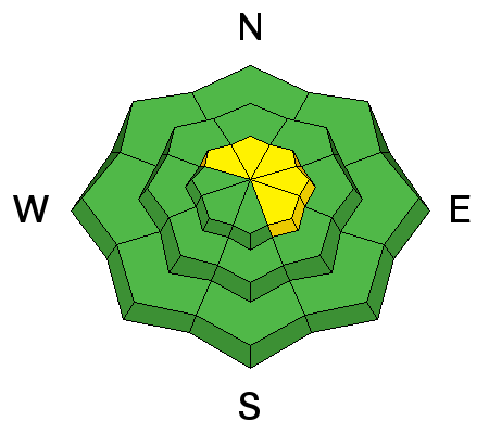
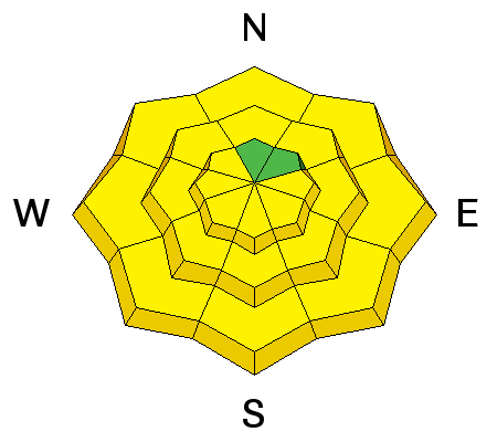
bottom line The avalanche danger is MODERATE for triggering a wind drift on upper elevation slopes, especially those facing northwest through easterly. The likelihood of triggering a drift increases with elevation, especially along ridge lines and the areas that recieved the most snow. There is also a MODERATE danger for triggering wet loose snow sluffs as the snow heats on almost any aspect and elevation except high north facing. Natural wet sluffs also possible if there is prolonged sun where you are.
|
 |
special announcement PLEASE HELP guide our discussions of website maintenance, upgrades or possible changes in coming years. Take this brief survey. As a way of saying thanks we'll be raffling a free avalanche class and other free stuff like hats, beanies, water bottles, etc. Do you need lift tickets to Snowbird, Snowbasin, Sundance, or Nordic Valley? Purchase them HERE at reduced prices. Every penny on these donated tickets benefits the Utah Avalanche Center. Check out our Garage Sale! Chock full of sweet backcountry gear - you can find the goods on our Facebook page here. |
 |
current conditions Under partly cloudy skies, temperatures are in the low twenties to upper 30s in the Ogden area mountians this morning. The southwesterly winds are averaging 10 to 15 mph at the mid elevations, while speeds have increased once again across the highest ridge lines and peaks, with averages 35 to 40 mph. The Ogden area mountains picked up about an inch of snow overnight.
Glimpses of sun yesterday instantly dampened the snow on the sunny slopes, which will be crusted this morning ‘til they soften, and the best powder will be on wind sheltered, shady slopes. |
 |
recent activity Yesterday, the larger triggers of explosives were able to release slides and cornices along the ridge lines, some large enough to bury a person. The snow and cornices were more sensitive in the mountains on the east side of the valley, which received significantly more snow from the storm. Here are two observations from yesterday.
|
| type | aspect/elevation | characteristics |
|---|

|
|
LIKELIHOOD
 LIKELY
UNLIKELY
SIZE
 LARGE
SMALL
TREND
 INCREASING DANGER
SAME
DECREASING DANGER
|
|
description
While most of the wind slabs should be less sensitive today, there will still be places where a person can trigger them. And the chance of triggering a wind slab increases significantly right along the highest and peaks, and in the mountains on the east side of the valley, where there was a storm total of 19" of snow. Use visual clues of round drifts, cracking of denser snow, cornices formation, and scouring to help identify when you are in wind-affected terrain.
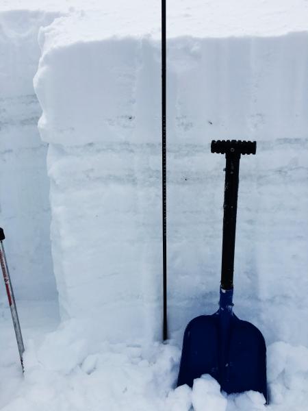
In Big Cottonwood, at least one slide broke below a crust, into older faceted snow – this is worrisome, and I am hoping it is not a trend. The Ogden area mountains also have a layerd snow pack at the upper elevations. So it’s all the more reason to travel cautiously in steep, upper elevation northerly through easterly facing terrain, avoid the heavily wind loaded slopes and dig down and evaluate the upper snow pack. Doug Wewer photo, Rodeo Ridge, NNE facing pit; wind pocket at 7,800'
|
| type | aspect/elevation | characteristics |
|---|

|
|
LIKELIHOOD
LIKELY
UNLIKELY
SIZE
LARGE
SMALL
TREND
 INCREASING DANGER
SAME
DECREASING DANGER
|
|
description
Wet loose sluffs are a bit more predictable, and hopefully that makes them easier to avoid. The snow will heat rapidly today, even with brief periods of sun, and both human triggered and natural wet loose sluffs are possible. When the snow becomes damp where you are and roller balls start to swarm, head to lower angle slopes or cooler aspects. Natural wet sluffs possible today, so avoid travel below steep sunny slopes and gullies. Green housing may occur with periods of thin clouds, heating the snow on the shady mid and low elevation northerly facing slopes as well.
|
 |
weather Skies will be partly cloudy today, with a mix of sun and clouds, and even a few snow flurries are possible, mostly north of I-80. The west to southwesterly winds will continue to be strong along the high elevation ridgelines, averaging to 40 mph. Speeds will drop off rapidly once you’re below the ridge lines, to averages of 10 to 15 mph. Ridge line temperatures will warm into the upper 20s today, and 8,000’ temperatures to near 40. A ridge will move over Utah for the weekend, with lots of sunshine and a significant warming trend |
| general announcements Remember your information can save lives. If you see anything we should know about, please help us out by submitting snow and avalanche conditions. You can also call us at 801-524-5304, email by clicking HERE, or include #utavy in your tweet or Instagram. To get help in an emergency (to request a rescue) in the Wasatch, call 911. Be prepared to give your GPS coordinates or the run name. Dispatchers have a copy of the Wasatch Backcountry Ski map. Backcountry Emergencies. It outlines your step-by-step method in the event of a winter backcountry incident. If you trigger an avalanche in the backcountry, but no one is hurt and you do not need assistance, please notify the nearest ski area dispatch to avoid a needless response by rescue teams. Thanks.
EMAIL ADVISORY If you would like to get the daily advisory by email you will need to subscribe here. DAWN PATROL Hotline updated daily by 5-530am - 888-999-4019 option 8. TWITTER Updates for your mobile phone - DETAILS UDOT canyon closures: LINK TO UDOT, or on Twitter, follow @UDOTavy, @CanyonAlerts or @AltaCentral Utah Avalanche Center mobile app - Get your advisory on your iPhone along with great navigation and rescue tools. Powderbird Helicopter Skiing - Blog/itinerary for the day Lost or Found something in the backcountry? - http://nolofo.com/ To those skinning uphill at resorts: it is critical to know the resort policy on uphill travel. You can see the uphill travel policy for each resort here. Benefit the Utah Avalanche Center when you shop from Backcountry.com or REI: Click this link for Backcountry.com or this link to REI, shop, and they will donate a percent of your purchase price to the UAC. Both offer free shipping (with some conditions) so this costs you nothing! Benefit the Utah Avalanche Center when you buy or sell on ebay - set the Utah Avalanche Center as a favorite non-profit in your ebay account here and click on ebay gives when you buy or sell. You can choose to have your seller fees donated to the UAC, which doesn't cost you a penny. This information does not apply to developed ski areas or highways where avalanche control is normally done. This advisory is from the U.S.D.A. Forest Service, which is solely responsible for its content. This advisory describes general avalanche conditions and local variations always exist. |