| Please join us at the 23rd annual Black Diamond Fall Fundraiser Party Thursday Sept 15. Tickets are on sale now here, at the Black Diamond store & at REI. Special bonus raffle for online ticket purchasers! |
| Please join us at the 23rd annual Black Diamond Fall Fundraiser Party Thursday Sept 15. Tickets are on sale now here, at the Black Diamond store & at REI. Special bonus raffle for online ticket purchasers! |
| Advisory: Ogden Area Mountains | Issued by Drew Hardesty for Saturday - March 12, 2016 - 7:05am |
|---|

|
bottom line Most terrain has a LOW avalanche danger. Areas of MODERATE danger exist for wet loose avalanches on all aspects and perhaps more pronounced on the steep low to mid elevation northerly aspects. Much depends on the cloud cover and the arrival of the forecasted cooler temps. The danger will be self-evident, however-if you find yourself in poorly consolidated or unsupportable wet snow, move to low angle terrain and avoid being in or above terrain traps. Here's a cool new tutorial on the North American Danger Scale by the Forest Service National Avalanche Center.
|
 |
special announcement The Utah Avalanche Center greatly values our longtime partnership with our world-class resorts and is blowing out the remaining donated lift tickets from Snowbird, Snowbasin, Sundance, and Nordic Valley with reduced prices. Every penny you spend benefits the Utah Avalanche Center. Check out our Garage Sale! Chock full of sweet backcountry gear - you can find the goods on our Facebook page here. |
 |
current conditions The intrepid backcountry recreationist will find partly to mostly cloudy skies this morning, light to moderate southwest winds, and stubbornly warm, well-above-freezing temperatures, particularly in the mid elevations. Yesterday, one could find soft, ride-able conditions in the high northerly aspects that had been spared from wind damage. On the flip side of the compass, just enough warmth and sun allowed for many southerlies to soften. |
 |
recent activity Minor wet push-a-lanches noted in the shady mid-elevations. La Sals Forecaster Eric Trenbeath was involved in a a rescue in his range two days ago. His report can be found here. |
| type | aspect/elevation | characteristics |
|---|

|
|
LIKELIHOOD
 LIKELY
UNLIKELY
SIZE
 LARGE
SMALL
TREND
 INCREASING DANGER
SAME
DECREASING DANGER
|
|
description
WARNING! Esoteric wet snow thoughts below. If you're in a hurry, skip to the Bottom line.
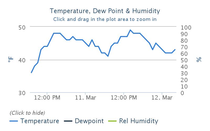
This (courtesy of Mesowest) - and well collated by the SLC NWS office shows 48 hours of temperatures at a good representative site - Ben Lomond. Elevation is just shy of 8000'. One can see that the last decent refreeze was the evening of the 9th. Snow stability is predicated upon a good diurnal melt-freeze cycle; and when the "freeze" part of the dance is lacking, you end up with more melt-water in the snowpack than you might want. A little water is ok, too much is not. At this point, much is then determined by how good the plumbing is in the house. I noted water running downhill adjacent to the LCC road yesterday - a good sign of decent plumbing - free water leaving the snowpack. Similarly, one can look at at the SNOTEL sites (courtesy of NRCS) to look at the snow pillow to gauge snow water equivalent. See below.
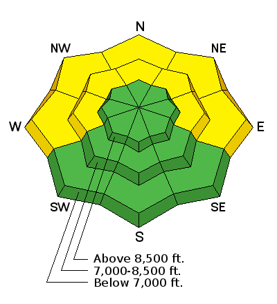
What one may gather is that a diminishing Snow Water Equivalent with these temps is that water is leaving the snowpack here as well. Also a good sign. Still, what we know is that the low to mid-elevation northerlies are the snowpacks going through the most transition right now and are lacking a good 48 hour refreeze. Cloud cover from last night also threw a wet blanket over much long wave radiational cooling of the snowpack. Yellow flag = yellow on the rose. |
 |
weather We'll see increasing clouds and perhaps even a hint of rain or snow in the north today. Cooler air will filter in today with a splitting storm and daytime highs will drop to the upper 20s. West to southwest winds will be in the 15mph range. Stonger southwest winds tomorrow pick up ahead of what looks to be a decent refresher for Sunday night into Monday. The models are not perfectly aligned, but I'd hazard a foot of snow or so with this system moving in out of the west northwest. It does look like strong northwest winds will accompany the snowfall through Monday, however. We'll keep an eye on how things are trending. |
| general announcements Remember your information can save lives. If you see anything we should know about, please help us out by submitting snow and avalanche conditions. You can also call us at 801-524-5304, email by clicking HERE, or include #utavy in your tweet or Instagram. To get help in an emergency (to request a rescue) in the Wasatch, call 911. Be prepared to give your GPS coordinates or the run name. Dispatchers have a copy of the Wasatch Backcountry Ski map. Backcountry Emergencies. It outlines your step-by-step method in the event of a winter backcountry incident. If you trigger an avalanche in the backcountry, but no one is hurt and you do not need assistance, please notify the nearest ski area dispatch to avoid a needless response by rescue teams. Thanks.
EMAIL ADVISORY If you would like to get the daily advisory by email you will need to subscribe here. DAWN PATROL Hotline updated daily by 5-530am - 888-999-4019 option 8. TWITTER Updates for your mobile phone - DETAILS UDOT canyon closures: LINK TO UDOT, or on Twitter, follow @UDOTavy, @CanyonAlerts or @AltaCentral Utah Avalanche Center mobile app - Get your advisory on your iPhone along with great navigation and rescue tools. Powderbird Helicopter Skiing - Blog/itinerary for the day Lost or Found something in the backcountry? - http://nolofo.com/ To those skinning uphill at resorts: it is critical to know the resort policy on uphill travel. You can see the uphill travel policy for each resort here. Benefit the Utah Avalanche Center when you shop from Backcountry.com or REI: Click this link for Backcountry.com or this link to REI, shop, and they will donate a percent of your purchase price to the UAC. Both offer free shipping (with some conditions) so this costs you nothing! Benefit the Utah Avalanche Center when you buy or sell on ebay - set the Utah Avalanche Center as a favorite non-profit in your ebay account here and click on ebay gives when you buy or sell. You can choose to have your seller fees donated to the UAC, which doesn't cost you a penny. This information does not apply to developed ski areas or highways where avalanche control is normally done. This advisory is from the U.S.D.A. Forest Service, which is solely responsible for its content. This advisory describes general avalanche conditions and local variations always exist. |